
Western Province is one of the 10 provinces in Zambia and encompasses most of the area formerly known as Barotseland. The capital is Mongu, and together with the neighbouring town of Limulunga, Mongu is treated as the capital of Barotseland.
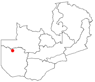
Lukulu is a market town in the Western Province of Zambia, on the Zambezi River, and headquarters of a district of the same name. Access to the town is limited to only a few graded roads with traffic running through it from Kaoma town to Watopa town. Fish from the river provide most of the local diet, and some are exported to other parts of Zambia away from the river. The town has very beautiful Zambezi River water front and sandy beaches.

Ileje District is a district in Songwe Region, Tanzania. It is bordered to the north by Mbeya Urban and Rungwe districts, to the east by Kyela District, to the northwest by Mbozi District and to the south by Zambia and Malawi.

Kohat District is a district in the Kohat Division of the Khyber Pakhtunkhwa province of Pakistan. Kohat city is its district capital.
Angkor Chum District is a district of Siem Reap Province, in north western Cambodia. According to the 1998 census of Cambodia, it had a population of 48,476.

Mongu District is a district of Zambia with headquarters at Mongu. As of the 2022 Zambian Census, the district had a population of 197,816 people. More than a quarter of whom live in Mongu town; the remainder live on the floodplain or its edge.

Sesheke District is one of the sixteen (16) districts in Western Province of Zambia. The capital lies at Sesheke. As of the 2022 Zambian Census, the district had a population of 72,655 people. It contains part of Sioma Ngwezi National Park and contains part of the Zambezi River, which forms part of Zambia's border with Namibia.

Kabwe District is a district of Zambia, located in Central Province. The capital lies at Kabwe. As of the 2010 Zambian Census, the district had a population of 299,206 people. It consists of two constituencies, namely Kabwe Central and Bwacha.

Kapiri Mposhi District is a district of Zambia, located in Central Province. The capital lies at Kapiri Mposhi. As of the 2022 Zambian Census, the district had a population of 371,068 people.

Chililabombwe District is a district of Zambia, located in Copperbelt Province. The capital is Chililabombwe. At the 2022 Zambian Census, the district had a population of 141,899.

Luanshya District is a district of Zambia, located in Copperbelt Province. The capital lies at Luanshya. As of the 2022 Zambian census, the district had a population of 211,966 people.

Kabompo District is a district of Zambia, located in North-Western Province. The capital lies at Kabompo. As of the 2022 Zambian Census, the district had a population of 65,760 people.
Choma District is a district of Zambia, located in Southern Province. The capital lies at Choma. As of the 2022 Zambian Census, the district had a population of 266,916 people. Choma has been the provincial capital of the Southern Province since 2012.

Chipata District is a district of Zambia, located in Eastern Province. The capital lies at Chipata. As of the 2022 Zambian Census, the district had a population of 327,059 people.
Petauke District is a district of Zambia, located in Eastern Province. The capital lies at Petauke. As of the 2022 Zambian Census, the district had a population of 259,385 people. It consists of two constituencies, namely Petauke Central and Kaumbwe.

Kawambwa District is a district of Zambia, located in Luapula Province. The capital lies at Kawambwa, which lies at the intersection of three roads: D19, M13, and Kawambwa-Mbereshi. As of the 2022 Zambian Census, the district had a population of 123,652 people. It consists of two constituencies, namely Kawambwa and Pambashe.

Mporokoso District is a district of Zambia, located in Northern Province. The capital lies at Mporokoso. As of the 2022 Zambian Census, the district had a population of 63,452 people.

Mitete District is a district of Zambia, located in Western Province. It was separated from Lukulu District in 2012.

Lukulu East is a constituency of the National Assembly of Zambia. It covers Lukulu District in Western Province, including the town of Lukulu.
