Copperbelt Province is a province in Zambia which covers the mineral-rich Copperbelt, and farming and bush areas to the south. It was the backbone of the Northern Rhodesian economy during British colonial rule and fuelled the hopes of the immediate post-independence period, but its economic importance was severely damaged by a crash in global copper prices in 1973. The province adjoins the Haut-Katanga province of the Democratic Republic of the Congo, which is similarly mineral-rich.
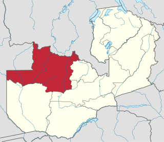
North-Western Province is one of ten Provinces of Zambia. It covers an area of 125,826 km2 (48,582 sq mi), has a population of 1,278,357 and a population density of 20 per square kilometre as of 2022. It is the most sparsely populated province in the country. The provincial capital is Solwezi. The literacy rate stood at 63 per cent in 2010 against a national average of 70.2 per cent. The rural population constituted 77.45%, while the urban population was 22.55%. North-Western Province is bordered along Angola in the west, the Democratic Republic of Congo in the north, Copperbelt Province in the east, Central in the south-east, and Western Province in the south-west.

Chadiza District with the headquarters at Chadiza lies in the extreme south-east corner of Zambia, bordering Mozambique to its south. The eastern half of the district is characterised by wooded rocky hills rising to 1330 m while the western half has the same character as the land around Chadiza town. This part of the district has been almost completely deforested and suffers soil erosion. In 2012, most of the eastern part of the district was declared its own district, namely Vubwi District.

Kalabo District is a district of Zambia, located in Western Province. The capital lies at Kalabo. As of the 2022 Zambian Census, the district had a population of 111,769 people. The district contains the Liuwa Plain National Park.

Mumbwa District is a district of Zambia, located in Central Province. The capital lies at Mumbwa. As of the 2022 Zambian Census, the district had a population of 332,237 people. It consists of two constituencies, being Mumbwa and Nangoma.

Chipata District is a district of Zambia, located in Eastern Province. The capital lies at Chipata. As of the 2022 Zambian Census, the district had a population of 327,059 people.

Lunga District is a district in the Luapula Province of Zambia. It was declared a district in 2012 by Michael Sata. The district comprises archipelago of islands in the Bangweulu Wetlands in the south-east of Lake Bangweulu. As of the 2022 Zambian Census, the district had a population of 39,383 people.

The Vubwi District is a district of Zambia, located in the Eastern Province. It was separated from Chadiza District in 2012. As of the 2022 Zambian Census, the district had a population of 53,080 people.

Limulunga District is a district of Zambia, located in Western Province. The seat of the district is Limulunga. It was made independent from Mongu District in 2012. As of the 2022 Zambian Census, the district had a population of 61,102 people.
Luampa District is a district of Zambia, located in Western Province. It was separated from Kaoma District in 2012. As of the 2022 Zambian Census, the district had a population of 61,023 people.

Mitete District is a district of Zambia, located in Western Province. It was separated from Lukulu District in 2012. As of the 2022 Zambian Census, the district had a population of 39,641 people.
Mulobezi District is a district of Zambia, located in Western Province. It was separated from Sesheke District in 2013. As of the 2022 Zambian Census, the district had a population of 45,326 people.

Nalolo District is a district of Zambia, located in Western Province. It was separated from Senanga District in 2012. As of the 2022 Zambian Census, the district had a population of 73,645 people.

Sikongo District is a district of Zambia, located in Western Province. It was separated from Kalabo District in 2012. As of the 2022 Zambian Census, the district had a population of 59,670 people.

Sioma District is a district of Zambia, located in Western Province on the west bank of the Zambezi River. The capital lies at Sioma. As of the 2022 Zambian Census, the district had a population of 65,539 people.

Chisamba District is a district of Central Province, Zambia. It covers a total surface area of 5,204.5 sq km and is known for its agricultural activities with over 32,000 small scale farming families and 256 commercial farmers, the majority of whom are white Zambians. It shares borders with Lusaka, Chongwe, Chibombo, Kabwe, Kapiri Mposhi and Luano Districts. As of the 2022 Zambian Census, the district had a population of 160,828 people.

Chitambo District is a district of Central Province, Zambia. It was separated from Serenje District in 2012 and is located some 357km north-east of Kabwe along the Great North Road. As of the 2022 Zambian Census, the district had a population of 100,603 people.

Chilanga District is a district of Lusaka Province, Zambia. The capital of the district is Chilanga. It was separated from Kafue District in 2012. As of the 2022 Zambian Census, the district had a population of 225,276 people.

Chirundu District is a district of Southern Province, Zambia. Its headquarters is Chirundu. It was separated from Siavonga District by President Michael Sata in 2012. As of the 2022 Zambian Census, the district had a population of 78,780 people.

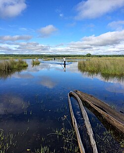
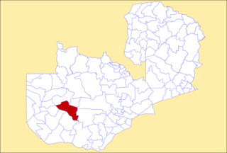
Manyinga District is a district of North-Western Province, Zambia. It was separated from Kabompo District in 2012. As of the 2022 Zambian Census, the district had a population of 75,030 people.