
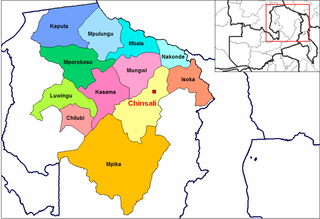
Northern Province is one of Zambia's ten provinces. It covers approximately one-sixth of Zambia in land area. The provincial capital is Kasama. The province is made up of 12 districts, namely Kasama District, Chilubi District, Kaputa District, Luwingu District, Mbala District, Mporokoso District, Mpulungu District, Mungwi District, Nsama District, Lupososhi District, Lunte District and Senga Hill District. Currently, only Kasama and Mbala have attained municipal council status, while the rest are still district councils. It is widely considered to be the heartland of the Bemba, one of the largest tribes in Zambia.
Mwanga, or Namwanga (Nyamwanga), is a Bantu language spoken by the Mwanga people in the Northern Province of Zambia and in Mbeya Region, Tanzania. The 2010 Zambian census found 140,000 speakers. The current number in Tanzania is unknown; Ethnologue cites a figure from 1987 of 87,000.
Chinsali is a town in Zambia, which is both the district headquarters of Chinsali District and provincial headquarters of Muchinga Province.
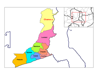
Chama is a small town in the Eastern Province of Zambia, and is headquarters of Chama District. It is one of the most remote district headquarters in the country, lying just inside the eastern edge of the upper Luangwa Rift Valley, at the foot of the highlands dividing Zambia and Malawi. It is served by only one gravel road which comes from Lundazi and the provincial capital of the Eastern Province, Chipata, 300 km to the south. A dirt track connects the town to the South Luangwa National Park 200 km south-west, running parallel to the Luangwa River. A little-used dirt track follows the Malawi border further north and crosses into Isoka District west of the Nyika Plateau. The Road Development Agency is also developing a road from Chama westwards across the Luangwa River to the town of Matumbo, where the road will end at a junction with the T2 Road, Zambia's Great North Road. It is meant to be the 2nd main road out of Chama after the Lundazi-Chipata Route and is meant to provide access for Chama Residents to the headquarters of Muchinga Province, which is Chinsali.

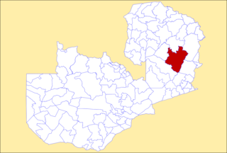
Chinsali District with headquarters at Chinsali is located in Muchinga Province, Zambia.
Kalulushi District is a district of Zambia, located in Copperbelt Province. The capital lies at Kalulushi. As of the 2000 Zambian Census, the district had a population of 75,806 people.

Luanshya District is a district of Zambia, located in Copperbelt Province. The capital lies at Luanshya. As of the 2000 Zambian census, the district had a population of 147,908 people.

Kalomo District is a district of Zambia, located in Southern Province. The capital lies at Kalomo. As of the 2000 Zambian census, the district had a population of 169,503 people.

Mazabuka District is a district of Zambia, located in Southern Province. The capital lies at Mazabuka. As of the 2000 Zambian Census, the district had a population of 203,219 people.
Petauke District is a district of Zambia, located in Eastern Province. The capital lies at Petauke. As of the 2000 Zambian Census, the district had a population of 235,879 people. It consists of two constituencies, namely Petauke Central and Kaumbwe.

Mwense District is a district of Zambia, located in Luapula Province. The capital lies at Mwense. As of the 2000 Zambian Census, the district had a population of 105,759 people.

Luwingu District is a district of Zambia, located in Northern Province. The capital lies at Luwingu. As of the 2000 Zambian Census, the district had a population of 80,758 people.

Mbala District is a district of Zambia, located in Northern Province. The capital lies at Mbala. The district borders Rukwa Region of Tanzania to the north. As of the 2000 Zambian Census, the district had a population of 149,634 people.
Mpika District is a district of Zambia, located in Muchinga Province. The capital lies at Mpika. As of the 2000 Zambian Census, the district had a population of 146,196 people. With the Luangwa River forming its eastern border, it has most of the South Luangwa National Park within its boundaries. It also contains the North Luangwa National Park.

Muchinga Province is one of the ten provinces of Zambia. It is located in the northeast of the country and borders with Tanzania in the north, Malawi in the east, Eastern Province in the south, Central Province in the southwest, Luapula Province in the west, and Northern Province in the northwest. The administrative center of the province is Chinsali.

Mafinga District is one of the eight districts of Muchinga Province in Zambia. The district headquarters is at Thendere. It also contains the town of Muyombe. It was named after the Mafinga Hills. The district is bordered to the north by Songwe Region of Tanzania.

Chipili District is a district of Zambia, located in Luapula Province. It was separated from Mwense District in 2012.

The Vubwi District is a district of Zambia, located in the Eastern Province. It was separated from Chadiza District in 2012.

Isoka is a constituency of the National Assembly of Zambia. It covers the towns of Chisato, Isoka, Mpangala and Papote in Isoka District of Muchinga Province.
The M14 is a road in the Muchinga Province of Zambia that connects Nakonde with the Malawian Border at Katumbi via Chitipa, Thendere and Muyombe.
