The Zambezi is the fourth-longest river in Africa, the longest east-flowing river in Africa and the largest flowing into the Indian Ocean from Africa. Its drainage basin covers 1,390,000 km2 (540,000 sq mi), slightly less than half of the Nile's. The 2,574 km (1,599 mi) river rises in Zambia and flows through eastern Angola, along the north-eastern border of Namibia and the northern border of Botswana, then along the border between Zambia and Zimbabwe to Mozambique, where it crosses the country to empty into the Indian Ocean.
Solwezi is a town in Zambia. It is the provincial capital of the mineral-rich North-Western Province. Solwezi is also the administrative capital of Solwezi District, one of the eleven districts in the North-Western Province.

Chingola is a town in Zambia's Copperbelt Province, the country's copper-mining region, with a population of 256,560. It is the home of Nchanga Copper Mine, a deep-shaft high-grade content copper mining operation, which subsequently led to the development of two open pit operations, Chingola Open Pit and then Nchanga Open Pit.

Kabwe is the capital of the Zambian Central Province and the Kabwe District, with a population estimated at 288,598 at the 2022 census. Named Broken Hill until 1966, it was founded when lead and zinc deposits were discovered in 1902. Kabwe also has a claim to being the birthplace of Zambian politics as it was an important political centre during the colonial period.
Mwinilunga is a town in the North-Western Province of Zambia. It is the headquarters of Mwinilunga District, one of the province's eleven districts.
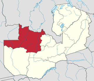
North-Western Province is one of ten Provinces of Zambia. It covers an area of 125,826 km2 (48,582 sq mi), has a population of 1,278,357 and a population density of 20 per square kilometre as of 2021. It is the most sparsely populated province in the country. The provincial capital is Solwezi. The literacy rate stood at 63 per cent in 2010 against a national average of 70.2 per cent. The rural population constituted 77.45%, while the urban population was 22.55%. North-Western Province is bordered along Angola in the west, the Democratic Republic of Congo in the north, Copperbelt Province in the east, Central in the south-east, and Western Province in the south-west.

The ten provinces of Zambia are divided into a total of 116 districts as of 2018.

The Sakeji School is a school near Kalene Hill in the remote Ikelenge District of north-western Zambia, just north of Mwinilunga. It is a Christian boarding school for primary students. It is mainly intended to serve the children of missionaries in the region, including Zambia, Angola and the Democratic Republic of the Congo, but the school also accepts expatriate and Zambian children.
ZESCO is a state-owned power company in Zambia. It is Zambia's largest power company producing about 80% of the electricity consumed in the country. ZESCO represents Zambia in the Southern African Power Pool.

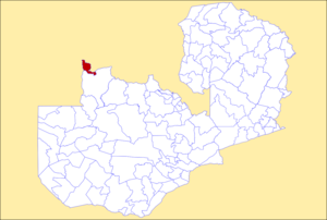
Mwinilunga District is a district of Zambia, located in North-Western Province. The capital lies at Mwinilunga. As of the 2022 Zambian Census, the district had a population of 136,770 people.
'Lumwana is a mining town located in Mwinilunga District, within the North-Western Province of Zambia.
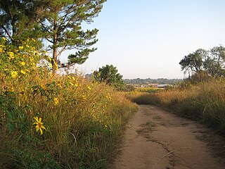
Kalene Hill is a community in the northwest of Zambia near a hill by the same name about 3 kilometres (2 mi) to the southeast. It is part of the Ikelenge District. Kalene Hill was the site of an early medical mission. The hospital is still important to the region.
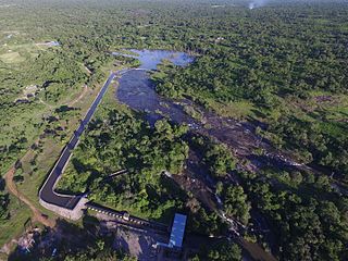
Zengamina is a small hydroelectric power generation plant near Kalene Hill, Ikelenge District in northwestern Zambia. It was built between 2004 and 2008 at a cost of about $3 million, or $4,285 per kilowatt of power.
The Sakeji River is a tributary of the Zambezi. The river rises to the south of Kalene Hill in Ikelenge District, Zambia. It flows northward to join the upper reaches of the Zambezi from the left.
Ikeleng'i is a constituency of the National Assembly of Zambia. It covers the towns of Ikeleng'i and Kalene Hill in North-Western Province.

Manyinga District is a district of North-Western Province, Zambia. It was separated from Kabompo District in 2012. As of the 2022 Zambian Census, the district had a population of 75,030 people.

Mushindamo District is a district of North-Western Province, Zambia. It was created from part of Solwezi District in 2016. However, as of 2021, it is not clear where the Mushindamo Central Business District is to be located.
The T5 is a trunk road in Zambia. It connects Chingola in the Copperbelt Province with Solwezi and Mwinilunga in the North-Western Province. The route extends to end at the Jimbe border post with Angola. It is the only other road after the M18 road that connects the towns of the North-Western and Copperbelt provinces and is currently the main route motorists use to reach Angola from Zambia. The section of the road from Chingola to Mutanda is a toll road.
The M8 road is a road in the North-Western Province of Zambia. It connects Mutanda in with Zambezi Town via Mufumbwe, Manyinga & Kabompo.