
Chadiza District with the headquarters at Chadiza lies in the extreme south-east corner of Zambia, bordering Mozambique to its south. The eastern half of the district is characterised by wooded rocky hills rising to 1330 m while the western half has the same character as the land around Chadiza town. This part of the district has been almost completely deforested and suffers soil erosion. In 2012, most of the eastern part of the district was declared its own district, namely Vubwi District.

Kaoma District with headquarters at Kaoma, Zambia is located in the north-eastern corner of Western Province. As of the 2022 Zambian Census, the district had a population of 146,690 people. The population lives mainly around Kaoma town and the northern parts of the district along the Luena and Luampa rivers. Its south-western portion is relatively uninhabited being very sandy with little water available in the dry season.

Chipata District is a district of Zambia, located in Eastern Province. The capital lies at Chipata. As of the 2022 Zambian Census, the district had a population of 327,059 people.

Kaputa District is a district of Zambia, located in Northern Province. The capital lies at Kaputa. As of the 2022 Zambian Census, the district had a population of 102,854 people.

Mafinga District is one of the eight districts of Muchinga Province in Zambia. The district headquarters is at Thendere. It also contains the town of Muyombe. It was named after the Mafinga Hills. As of the 2022 Zambian Census, the district had a population of 102,533 people.

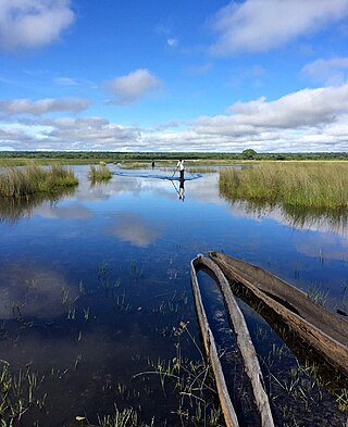
Lunga District is a district in the Luapula Province of Zambia. It was declared a district in 2012 by Michael Sata. The district comprises archipelago of islands in the Bangweulu Wetlands in the south-east of Lake Bangweulu. As of the 2022 Zambian Census, the district had a population of 39,383 people.
Luampa District is a district of Zambia, located in Western Province. It was separated from Kaoma District in 2012. As of the 2022 Zambian Census, the district had a population of 61,023 people.

Mitete District is a district of Zambia, located in Western Province. It was separated from Lukulu District in 2012. As of the 2022 Zambian Census, the district had a population of 39,641 people.
Mulobezi District is a district of Zambia, located in Western Province. It was separated from Sesheke District in 2013. As of the 2022 Zambian Census, the district had a population of 45,326 people.
Mwandi District is a district of Zambia, located in Western Province. The capital lies at Mwandi. It was separated from Sesheke District in 2012. As of the 2022 Zambian Census, the district had a population of 40,418 people.

Nalolo District is a district of Zambia, located in Western Province. It was separated from Senanga District in 2012. As of the 2022 Zambian Census, the district had a population of 73,645 people.

Chisamba District is a district of Central Province, Zambia. It covers a total surface area of 5,204.5 sq km and is known for its agricultural activities with over 32,000 small scale farming families and 256 commercial farmers, the majority of whom are white Zambians. It shares borders with Lusaka, Chongwe, Chibombo, Kabwe, Kapiri Mposhi and Luano Districts. As of the 2022 Zambian Census, the district had a population of 160,828 people.

Chitambo District is a district of Central Province, Zambia. It was separated from Serenje District in 2012 and is located some 357km north-east of Kabwe along the Great North Road. As of the 2022 Zambian Census, the district had a population of 100,603 people.

Luano District is a district of Central Province, Zambia. It was separated from Mkushi District in 2012. As of the 2022 Zambian Census, the district had a population of 66,679 people.

Ngabwe District is a district of Central Province, Zambia. It was separated from Kapiri Mposhi District in 2012. As of the 2022 Zambian Census, the district had a population of 42,104 people.

Chilanga District is a district of Lusaka Province, Zambia. The capital of the district is Chilanga. It was separated from Kafue District in 2012. As of the 2022 Zambian Census, the district had a population of 225,276 people.

Chirundu District is a district of Southern Province, Zambia. Its headquarters is Chirundu. It was separated from Siavonga District by President Michael Sata in 2012. As of the 2022 Zambian Census, the district had a population of 78,780 people.
Nsama District is a district of Northern Province, Zambia. It was created in February 2012 by splitting Kaputa District. As of the 2022 Zambian Census, the district had a population of 77,651 people.

Senga District is a district of Northern Province, Zambia. It was separated from Mbala District in 2016. As of the 2022 Zambian Census, the district had a population of 126,308 people.

Ikelenge District is a district of North-Western Province, Zambia. It was separated from Mwinilunga District in 2011. As of the 2022 Zambian Census, the district had a population of 44,775 people.
