
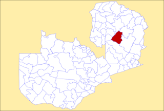
Chipata is a city and administrative centre of the Eastern Province of Zambia and Chipata District. It was declared the 5th city of the country, after Lusaka, Ndola, Kitwe and Livingstone, by President Edgar Lungu on 24 February 2017. The city has undergone rapid economic and infrastructure growth in the years, leading up to city status.

Central Province is one of Zambia's ten provinces. The provincial capital is Kabwe, which is the home of the Mulungushi Rock of Authority. Central Province has an area of 94,394 km (58,654 mi). It borders eight other provinces and has eleven districts. The total area of forest in the province is 9,095,566 ha, and it has a national park and three game management areas. The first mine in the region was opened up in 1905 making the then Broken Hill town the first mining town. In 1966, the town's name was reverted to its indigenous name - Kabwe meaning 'ore' or 'smelting'.

Lusaka Province is one of the ten provinces of Zambia. It is the smallest in terms of land area, covering 21,896 km2. However, it is the most populated and densely populated province in Zambia, with a population of 3,079,964 as of 2022 and a population density of 140 persons per km2.

Muchinga Province is one of the ten provinces of Zambia. It is located in the northeast of the country and borders with Tanzania in the north, Malawi in the east, Eastern Province in the south, Central Province in the southwest, Luapula Province in the west, and Northern Province in the northwest. The administrative center of the province is Chinsali.

Chisamba District is a district of Central Province, Zambia. It covers a total surface area of 5,204.5 sq km and is known for its agricultural activities with over 32,000 small scale farming families and 256 commercial farmers, the majority of whom are white Zambians. It shares borders with Lusaka, Chongwe, Chibombo, Kabwe, Kapiri Mposhi and Luano Districts. As of the 2022 Zambian Census, the district had a population of 160,828 people.

Ngabwe District is a district of Central Province, Zambia. It was separated from Kapiri Mposhi District in 2012. As of the 2022 Zambian Census, the district had a population of 42,104 people.

Chilanga District is a district of Lusaka Province, Zambia. The capital of the district is Chilanga. It was separated from Kafue District in 2012. As of the 2022 Zambian Census, the district had a population of 225,276 people.

Chirundu District is a district of Southern Province, Zambia. Its headquarters is Chirundu. It was separated from Siavonga District by President Michael Sata in 2012. As of the 2022 Zambian Census, the district had a population of 78,780 people.
Kanchibiya District is a district of Muchinga Province, Zambia. It was separated from Mpika District in 2017. As of the 2022 Zambian Census, the district had a population of 93,052 people.

Lavushimanda District is a district of Muchinga Province, Zambia. It was named after the Lavushi Manda National Park and separated from Mpika District in 2017. It also contains a town centre of the same name on the Great North Road. As of the 2022 Zambian Census, the district had a population of 55,755 people.

Kalumbila District is a district of North-Western Province, Zambia. It was named after a mine of the same name and was made independent from Solwezi District In 2016. As of the 2022 Zambian Census, the district had a population of 177,067 people.

Mushindamo District is a district of North-Western Province, Zambia. It was created from part of Solwezi District in 2016. However, as of 2021, it is not clear where the Mushindamo Central Business District is to be located.

Nkeyema District is a district of Western Province, Zambia. It was separated from Kaoma District in 2012. As of the 2022 Zambian Census, the district had a population of 106,074 people.

Chasefu District is a district of Eastern Province, Zambia. It was made independent from Lundazi District in 2018. As of the 2022 Zambian Census, the district had a population of 131,160 people.

Lupososhi District is a district of Northern Province, Zambia. It was created in 2018 by splitting Luwingu District. As of the 2022 Zambian Census, the district had a population of 79,614 people.

Chifunabuli District is a district of Luapula Province, Zambia. It was created in 2018 by splitting Samfya District. As of the 2022 Zambian Census, the district had a population of 116,326 people.

Kasenengwa District is a district of Eastern Province, Zambia. It was made independent from Chipata District in 2018. As of the 2022 Zambian Census, the district had a population of 155,565 people.

Lumezi District is a district of Eastern Province, Zambia. It was made independent from Lundazi District in 2018. As of the 2022 Zambian Census, the district had a population of 158,971 people.

Chipangali District is a district of Eastern Province, Zambia. It was made independent from Chipata District in 2018. As of the 2022 Zambian Census, the district had a population of 169,357 people.

Lusangazi District is a district of Eastern Province, Zambia. It was made independent from Petauke District in 2018. As of the 2022 Zambian Census, the district had a population of 110,523 people.
