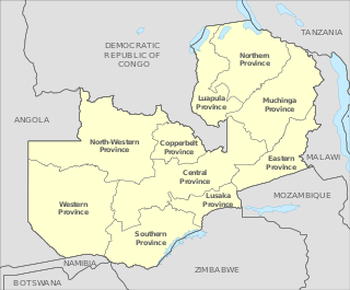
Zambia is divided into ten provinces. The provinces are further subdivided into districts. The Provincial Administration is headed by a Provincial Minister, who is appointed by the President, and is responsible for overseeing the implementation of government policies and coordinating the activities of various government departments within the province. The Provincial Minister is supported by a Provincial Permanent Secretary, who handles the day-to-day administration. Each province has a Provincial Development Coordinating Committee (PDCC) that plays a key role in development planning and coordinating projects within the province.

Western Province is one of the 10 provinces in Zambia and encompasses most of the area formerly known as Barotseland. The capital is Mongu, and together with the neighbouring town of Limulunga, Mongu is treated as the capital of Barotseland.

Northern Province is one of Zambia's ten provinces. It covers approximately one-sixth of Zambia in land area. The provincial capital is Kasama. The province is made up of 12 districts, namely Kasama District, Chilubi District, Kaputa District, Luwingu District, Mbala District, Mporokoso District, Mpulungu District, Mungwi District, Nsama District, Lupososhi District, Lunte District and Senga Hill District. Currently, only Kasama and Mbala have attained municipal council status, while the rest are still district councils. It is widely considered to be the heartland of the Bemba, one of the largest tribes in Zambia.

Choma is a town that serves as the capital of the Southern Province of Zambia. It is also the capital of Choma District, one of the 15 administrative districts in the province.

Central Province is one of Zambia's ten provinces. The provincial capital is Kabwe, which is the home of the Mulungushi Rock of Authority. Central Province has an area of 94,394 km (58,654 mi). It borders eight other provinces and has eleven districts. The total area of forest in the province is 9,095,566 ha, and it has a national park and three game management areas. The first mine in the region was opened up in 1905 making the then Broken Hill town the first mining town. In 1966, the town's name was reverted to its indigenous name - Kabwe meaning 'ore' or 'smelting'.

Lusaka Province is one of the ten provinces of Zambia. It is the smallest in terms of land area, covering 21,896 km2. However, it is the most populated and densely populated province in Zambia, with a population of 3,079,964 as of 2022 and a population density of 140 persons per km2.

Southern Province is one of Zambia's ten provinces. It is home to Zambia's premier tourist attraction, Mosi-oa-Tunya, shared with Zimbabwe. The centre of the province, the Southern Plateau, has the largest area of commercial farmland of any Zambian province, and produces most of the maize crop.

The ten provinces of Zambia are divided into a total of 116 districts as of 2018.

The T1 or Lusaka–Livingstone Road is the main highway of the Southern Province of Zambia. It begins 55 kilometres south of the city of Lusaka and heads south-west to the principal tourist destination, Victoria Falls in Livingstone, via Mazabuka, Monze, Choma and Kalomo, measuring approximately 430 kilometres (267 mi). The entire route is part of Trans-African Highway network number 4 or Cairo-Cape Town Highway between Cairo and Cape Town.

Kasama District is a central district of Northern Province, Zambia. It surrounds the provincial capital of Kasama town. As of the 2000 Zambian Census, the district had a population of 170,929 people. It consists of two constituencies, namely Kasama Central and Lukashya.

Lusaka is the capital and largest city of Zambia. It is one of the fastest-developing cities in southern Africa. Lusaka is in the southern part of the central plateau at an elevation of about 1,279 metres (4,196 ft). As of 2019, the city's population was about 3.3 million, while the urban population is estimated at 2.5 million in 2018. Lusaka is the centre of both commerce and government in Zambia and connects to the country's four main highways heading north, south, east, and west. English is the official language of the city administration, while Bemba and Nyanja are the commonly spoken street languages.

Itezhi-Tezhi District is a district of Zambia, located in Southern Province. The capital lies at Itezhi-Tezhi. As of the 2022 Zambian Census, the district had a population of 130,216 people.

Livingstone District is a district of Zambia, located in Southern Province. The capital lies at Livingstone. As of the 2022 Zambian Census, the district had a population of 177,393 people. Its border with Zimbabwe is formed by the Zambezi River and Victoria Falls. Although most people live in Livingstone, other villages include Jinga Jinga in the north and Simonga in the southwest.

Monze District is a district of Zambia, located in Southern Province. The capital lies at Monze. As of the 2022 Zambian Census, the district had a population of 268,432 people.

Chipata District is a district of Zambia, located in Eastern Province. The capital lies at Chipata. As of the 2010 Zambian Census, the district had a population of 455,783 people.

Rufunsa District is a district in Zambia, located in Lusaka Province. The district capital is Rufunsa. The district was established by President Michael Sata in 2012 by splitting Chongwe District. As of the 2022 Zambian census, it has a population of 81,733.

Muchinga Province is one of the ten provinces of Zambia. It is located in the northeast of the country and borders with Tanzania in the north, Malawi in the east, Eastern Province in the south, Central Province in the southwest, Luapula Province in the west, and Northern Province in the northwest. The administrative center of the province is Chinsali.
Daniel Munkombwe was a Zambian politician. He worked as a political organizer and administrator for the ZANC in Northern Rhodesia before and after independence. He was elected to Parliament for Choma constituency in 1973 and served for 19 years. In 2001, he was appointed Minister for the Southern Province by Levy Mwanawasa and continued in that and other government posts until 2015, having been subsequently appointed by Rupiah Banda and Michael Sata.

The T2 is a trunk road in Zambia. The road runs from the Tunduma border with Tanzania via Mpika, Kabwe and Lusaka to the Chirundu border with Zimbabwe. The road is the longest route of the country, as it is approximately 1,155 kilometres (718 mi). The route from Mpika to Kafue is a toll road. The route from Tanzania to Lusaka is Zambia's Great North Road and is part of the Tanzam Highway.

Pemba District is a district of Southern Province, Zambia. The district capital is Pemba. It was separated from Choma District in 2012.


