
Gandhinagar is the capital of the state of Gujarat in India. Gandhinagar is located approximately 23 km north of Ahmedabad, on the west central point of the industrial corridor between the megacities of Delhi and Mumbai.
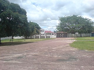
Mbala is Zambia's most northerly large town and seat of Mbala District in Northern Province, occupying a strategic location close to the border with Tanzania and controlling the southern approaches to Lake Tanganyika, 40 km by road to the north-west, where the port of Mpulungu is located. It had a population of about 20,000 in 2006. Under the name Abercorn, Mbala was a key outpost in British colonial control of this part of south-central Africa.

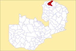
Northern Province is one of Zambia's ten provinces. It covers approximately one-sixth of Zambia in land area. The provincial capital is Kasama. The province is made up of 12 districts, namely Kasama District, Chilubi District, Kaputa District, Luwingu District, Mbala District, Mporokoso District, Mpulungu District, Mungwi District, Nsama District, Lupososhi District, Lunte District and Senga Hill District. Currently, only Kasama and Mbala have attained municipal council status, while the rest are still district councils. It is widely considered to be the heartland of the Bemba, one of the largest tribes in Zambia.
Mongu is the capital of Western Province in Zambia and was the capital of the formerly-named province and historic state of Barotseland. Its population is 179,585, and it is also the headquarters of Mongu District. Mongu is the home of the Litunga, King of the Lozi people.

Kalabo is an urban centre and the seat of Kalabo District, in the Western Province of Zambia.

Akola district is a district in the Indian state of Maharashtra. The city of Akola is the district headquarters. Akola district forms the central part of Amravati Division, which was the former British Raj Berar Province.

Mandsaur district is a District of Madhya Pradesh state in central India. The town of Mandsaur is the administrative headquarters of the district.The ancient Pashupatinath temple is situated in Mandsaur. Large quantities of opium are produced in Mandsaur district.

Dungarpur District is a district of the state of Rajasthan in western India. The town of Dungarpur is the district headquarters.
Khowai is a town located in the Indian state of Tripura and a Municipal Council in Khowai district. The city lies on the banks of Khowai river and hence from the river the city gets its name. It was originally settled upon by Upendranath Roy. Located near the Bangladesh border, Khowai has boundaries with Bangladesh on its entire northern part.

Australia's climate is governed mostly by its size and by the hot, sinking air of the subtropical high pressure belt. This moves north-west and north-east with the seasons. The climate is variable, with frequent droughts lasting several seasons, thought to be caused in part by the El Niño-Southern Oscillation. Australia has a wide variety of climates due to its large geographical size. The largest part of Australia is desert or semi-arid. Only the south-east and south-west corners have a temperate climate and moderately fertile soil. The northern part of the country has a tropical climate, varying between grasslands and desert. Australia holds many heat-related records: the continent has the hottest extended region year-round, the areas with the hottest summer climate, and the highest sunshine duration.

Nyagatare is the largest and second most populous district (akarere) in Rwanda. Located in Eastern Province, Rwanda, it occupies the northeastern extremity of Rwanda. Its capital is Nyagatare City, the former capital of the now defunct Umutara province. Nyagatare District borders Uganda in the North, Tanzania in the East, Gatsibo District of the in the South, and Gicumbi District of the Northern Province in the West. Nyagatare has an area of 1741 km2, what makes it the largest district in Rwanda. With a population of 466,944 in 2012, and 653,861 in 2022, Nyagatare is the second most populated district of Rwanda only after Gasabo District of Kigali City with 879,505 inhabitants. This is a 156% increase from 2002 when the population was only 255,104. This sharp rise in the population is mainly due to the major movement of the population from other parts of the country in search of land.

The climate of Zambia in Central and Southern Africa is definitely tropical modified by altitude (elevation). In the Köppen climate classification, most of the country is classified as humid subtropical or tropical wet and dry, with small patches of semi-arid steppe climate in the south-west.
Nabi Osman is a village in Baalbek District, Lebanon. It is located in the northern part of the Bekaa Valley, on the lower slopes of the Anti-Lebanon mountain range, and lies on the highway linking Lebanon and Syria. The town is home to a public school and The Malik Wehbe library.

Mbala District is a district of Zambia, located in Northern Province. The capital lies at Mbala. As of the 2022 Zambian Census, the district had a population of 161,595 people.

Mporokoso District is a district of Zambia, located in Northern Province. The capital lies at Mporokoso. As of the 2022 Zambian Census, the district had a population of 63,452 people.

Mungwi District is a district of Zambia, located in Northern Province. The capital lies at Mungwi. As of the 2022 Zambian Census, the district had a population of 205,096 people.

The Itigi-Sumbu thicket is an ecoregion consisting of two small areas of thick shrubland in Tanzania, Zambia and the adjacent Democratic Republic of the Congo, in East Africa. The floral community of dense deciduous brush is unique, with many endemic species, and almost no transition zone between it and the surrounding dry miombo woodlands. The distinctive nature of this small region is partly due to its setting on dry alluvial soil over a hard duricrust, while the surrounding areas are rocky hills and plateaus.
Nsama District is a district of Northern Province, Zambia. It was created in February 2012 by splitting Kaputa District.
Campbell Creek is a locality in the North Burnett Region, Queensland, Australia. In the 2021 census, Campbell Creek had "no people or a very low population".

Lupososhi District is a district of Northern Province, Zambia. It was created in 2018 by splitting Luwingu District.
