
Western Province is one of the 10 provinces in Zambia and encompasses most of the area formerly known as Barotseland. The capital is Mongu, and together with the neighbouring town of Limulunga, Mongu is treated as the capital of Barotseland.

Sesheke is a border town in the Western Province of Zambia, in a district of the same name. It lies on the northern bank of the Zambezi River which forms the border with Namibia's Caprivi Strip at that point.
Phnum Kravanh district is a district in Pursat province, Cambodia. In English the name translates to the Cardamom Mountains.

Chadiza District with the headquarters at Chadiza lies in the extreme south-east corner of Zambia, bordering Mozambique to its south. The eastern half of the district is characterised by wooded rocky hills rising to 1330 m while the western half has the same character as the land around Chadiza town. This part of the district has been almost completely deforested and suffers soil erosion. In 2012, most of the eastern part of the district was declared its own district, namely Vubwi District.

Chinsali District with headquarters at Chinsali is located in Muchinga Province, Zambia.

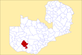
Shangombo District with headquarters at Shangombo is located in Zambia. As of the 2022 Zambian Census, the district had a population of 73,822 people.

Lukulu District is a district of Zambia, located in Western Province. The capital lies at Lukulu. As of the 2022 Zambian Census, the district had a population of 96,290 people.

Kabwe District is a district of Zambia, located in Central Province. The capital lies at Kabwe. As of the 2010 Zambian Census, the district had a population of 299,206 people. It consists of two constituencies, namely Kabwe Central and Bwacha.

Chililabombwe District is a district of Zambia, located in Copperbelt Province. The capital is Chililabombwe. At the 2022 Zambian Census, the district had a population of 141,899.

Chingola District is a district of Zambia, located in Copperbelt Province. The capital lies at Chingola. As of the 2022 Zambian Census, the district had a population of 299,936 people. It is divided into two constituencies, namely Chingola constituency and Nchanga constituency.

Kitwe District is a district of Zambia, located in Copperbelt Province. The capital is Kitwe. As of the 2022 Zambian Census, the district had a population of 661,901 people.

Luanshya District is a district of Zambia, located in Copperbelt Province. The capital lies at Luanshya. As of the 2022 Zambian census, the district had a population of 211,966 people.

Zambezi District is a district of Zambia, located in North-Western Province. The capital lies at Zambezi. As of the 2022 Zambian Census, the district had a population of 108,220 people. It consists of two constituencies, namely Zambezi West and Zambezi East.

Livingstone District is a district of Zambia, located in Southern Province. The capital lies at Livingstone. As of the 2022 Zambian Census, the district had a population of 177,393 people. Its border with Zimbabwe is formed by the Zambezi River and Victoria Falls. Although most people live in Livingstone, other villages include Jinga Jinga in the north and Simonga in the southwest.

Lundazi District is a district of Zambia, located in Eastern Province. The capital lies at Lundazi. As of the 2022 Zambian Census, the district had a population of 154,908 people. In 2018, Lundazi district was divided into 3 districts by the Government of the Republic of Zambia to enable rural development.

Kawambwa District is a district of Zambia, located in Luapula Province. The capital lies at Kawambwa, which lies at the intersection of three roads: D19, M13, and Kawambwa-Mbereshi. As of the 2022 Zambian Census, the district had a population of 123,652 people. It consists of two constituencies, namely Kawambwa and Pambashe.

Kaputa District is a district of Zambia, located in Northern Province. The capital lies at Kaputa. As of the 2022 Zambian Census, the district had a population of 102,854 people.
Mulobezi District is a district of Zambia, located in Western Province. It was separated from Sesheke District in 2013.
Mwandi District is a district of Zambia, located in Western Province. The capital lies at Mwandi. It was separated from Sesheke District in 2012.

Sesheke is a constituency of the National Assembly of Zambia. It covers Sesheke and surrounding towns in Sesheke District of Western Province.
