This article is about the Transport in Zambia.

Bangweulu — 'where the water sky meets the sky' — is one of the world's great wetland systems, comprising Lake Bangweulu, the Bangweulu Swamps and the Bangweulu Flats or floodplain. Situated in the upper Congo River basin in Zambia, the Bangweulu system covers an almost completely flat area roughly the size of Connecticut or East Anglia, at an elevation of 1,140 m straddling Zambia's Luapula Province and Northern Province. It is crucial to the economy and biodiversity of northern Zambia, and to the birdlife of a much larger region, and faces environmental stress and conservation issues.

The Luapula River is a north-flowing river of central Africa, within the Congo River watershed. It rises in the wetlands of Lake Bangweulu (Zambia), which are fed by the Chambeshi River. The Luapula flows west then north, marking the border between Zambia and the Democratic Republic of the Congo before emptying into Lake Mweru. The river gives its name to Zambia's Luapula Province.

Northern Province is one of Zambia's ten provinces. It covers approximately one-sixth of Zambia in land area. The provincial capital is Kasama. The province is made up of 12 districts, namely Kasama District, Chilubi District, Kaputa District, Luwingu District, Mbala District, Mporokoso District, Mpulungu District, Mungwi District, Nsama District, Lupososhi District, Lunte District and Senga Hill District. Currently, only Kasama and Mbala have attained municipal council status, while the rest are still district councils. It is widely considered to be the heartland of the Bemba, one of the largest tribes in Zambia.
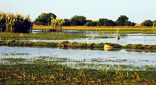
The Bangweulu Wetlands is a wetland ecosystem adjacent to Lake Bangweulu in north-eastern Zambia. The area has been designated as one of the world's most important wetlands by the Ramsar Convention and an "Important Bird Area" by BirdLife International. African Parks began managing Bangweulu in partnership with Zambia's Department of National Parks and Wildlife with the establishment of the Bangweulu Wetland Management Board in 2008.

Mansa is the capital of the Luapula Province of Zambia, and headquarters of Mansa District. It takes its name from the local Chief Mansa and the small Mansa River which flows west to the Luapula River. During British rule the city was named Fort Rosebery.
Samfya is a town located in the Zambian province of Luapula. It is the centre of Samfya District. The town is located on the south-western shore of Lake Bangweulu, on the longest stretch of well-defined shore of that lake. Samfya has a few guesthouses and a number of white sandy beaches which are used for recreation, although the lake does have crocodiles.

Central Province is one of Zambia's ten provinces. The provincial capital is Kabwe, which is the home of the Mulungushi Rock of Authority. Central Province has an area of 94,394 km (58,654 mi). It borders eight other provinces and has eleven districts. The total area of forest in the province is 9,095,566 ha, and it has a national park and three game management areas. The first mine in the region was opened up in 1905 making the then Broken Hill town the first mining town. In 1966, the town's name was reverted to its indigenous name - Kabwe meaning 'ore' or 'smelting'.

Luapula Province is one of Zambia's ten provinces located in the northern part of the country. Luapula Province is named after the Luapula River and its capital is Mansa. As per the 2022 Zambian census, the Province had a population of 1,519,478, which accounted for 7.72 per cent of the total Zambian population.
The Livingstone Memorial, built in 1899, marks the spot where missionary explorer David Livingstone died on 1 May 1873, in Chief Chitambo's village at Chipundu, near the edge of the Bangweulu Swamps in Zambia. His body was embalmed and his heart was buried there under a mpundu tree by his followers, now led by his loyal attendants Chuma and Susi, who then departed for the coast carrying his body. In their party was an Indian-educated African man named Jacob Wainwright who carved the inscription "LIVINGSTONE MAY 4 1873" and the names of the attendants on the tree.

The Congo Pedicle road crosses the Congolese territory of the Congo Pedicle and was constructed by and is maintained by Zambia to connect its Copperbelt and Luapula Provinces. Both the road and the territory may be referred to as ‘the Pedicle’. It is designated as the N36 Route on the Congolese Road Network.
Water transport and the many navigable inland waterways in Zambia have a long tradition of practical use except in parts of the south. Since draught animals such as oxen were not heavily used, water transport was usually the only alternative to going on foot until the 19th century. The history and current importance of Zambian waterways, as well as the types of indigenous boats used, provide information on this important aspect of Zambian economy.

Chilubi is a settlement on an island in Lake Bangweulu and its swamps, and is headquarters of Chilubi District in the Northern Province of Zambia.

Chilubi District with headquarters at Chilubi is located in Northern Province, Zambia. It covers the north-east Lake Bangweulu and Bangweulu Wetlands containing several islands including Chilubi Island, and some of the mainland northeast of the lake. As of the 2022 Zambian Census, the district had a population of 114,011 people.
Chifita Matafwali was a Zambian politician. He was a member of the National Assembly for the Bangweulu constituency for the Patriotic Front since the 2011 elections.

Lunga District is a district in the Luapula Province of Zambia. It was declared a district in 2012 by Michael Sata. The district comprises archipelago of islands in the Bangweulu Wetlands in the south-east of Lake Bangweulu. As of the 2022 Zambian Census, the district had a population of 39,383 people.

Bangweulu is a constituency of the National Assembly of Zambia. It covers an area to the south of Lake Bangweulu in Samfya District, including the town of Samfya, in Luapula Province.

Lupososhi District is a district of Northern Province, Zambia. It was created in 2018 by splitting Luwingu District. As of the 2022 Zambian Census, the district had a population of 79,614 people.

Chifunabuli District is a district of Luapula Province, Zambia. It was created in 2018 by splitting Samfya District. As of the 2022 Zambian Census, the district had a population of 116,326 people.
The M3 road is a road in northern Zambia that connects Kasama in the Northern Province with the Congo Pedicle border at Chembe in the Luapula Province via Luwingu and Mansa. The road contains two tollgates between Kasama and Mansa.
