
The Zambezi is the fourth-longest river in Africa, the longest east-flowing river in Africa and the largest flowing into the Indian Ocean from Africa. Its drainage basin covers 1,390,000 km2 (540,000 sq mi), slightly less than half of the Nile's. The 2,574 km (1,599 mi) river rises in Zambia and flows through eastern Angola, along the north-eastern border of Namibia and the northern border of Botswana, then along the border between Zambia and Zimbabwe to Mozambique, where it crosses the country to empty into the Indian Ocean.

The Zambezi Region is one of Namibia's fourteen regions, situated in the north-eastern part of the country along the Zambezi River where it gets its name from. The region's capital is the town of Katima Mulilo. The Katima Mulilo Airport is 18 kilometres south-west of the town, while the village of Bukalo is located 43 kilometres south-east of Katima Mulilo. Formerly known as the Caprivi Region until 2013, it has eight electoral constituencies and a population of 142,373 according to the 2023 census.

Western Province is one of the 10 provinces in Zambia and encompasses most of the area formerly known as Barotseland. The capital is Mongu, and together with the neighbouring town of Limulunga, Mongu is treated as the capital of Barotseland.
Mwinilunga is a town in the North-Western Province of Zambia. It is the headquarters of Mwinilunga District, one of the province's eleven districts.

Kalabo is an urban centre and the seat of Kalabo District, in the Western Province of Zambia.

Lusaka Province is one of the ten provinces of Zambia. It is the smallest in terms of land area, covering 21,896 km2. However, it is the most populated and densely populated province in Zambia, with a population of 3,079,964 as of 2022 and a population density of 140 persons per km2.

Southern Province is one of Zambia's ten provinces. It is home to Zambia's premier tourist attraction, Mosi-oa-Tunya, shared with Zimbabwe. The centre of the province, the Southern Plateau, has the largest area of commercial farmland of any Zambian province, and produces most of the maize crop.
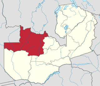
North-Western Province is one of ten Provinces of Zambia. It covers an area of 125,826 km2 (48,582 sq mi), has a population of 1,278,357 and a population density of 20 per square kilometre as of 2021. It is the most sparsely populated province in the country. The provincial capital is Solwezi. The literacy rate stood at 63 per cent in 2010 against a national average of 70.2 per cent. The rural population constituted 77.45%, while the urban population was 22.55%. North-Western Province is bordered along Angola in the west, the Democratic Republic of Congo in the north, Copperbelt Province in the east, Central in the south-east, and Western Province in the south-west.

Chinsali District with headquarters at Chinsali is located in Muchinga Province, Zambia.

Shangombo District with headquarters at Shangombo is located in Zambia. As of the 2010 Zambian Census, the district had a population of 84,070 people. This population is a combined figure with the newly created district of Sioma which was created by halving the primary district. The western part of the half retains the name Shangombo while the eastern part is called Sioma District.

Sesheke District is one of the sixteen (16) districts in Western Province of Zambia. Lying 300km south of the provincial capital, Mongu and 190km from Livingstone, the nations tourist capital, the district shares borders with Sioma in the west, Senanga and Mulobezi in the north-east and Mwandi in the east. The district also shares international border with Namibia south and Angola in south-west. The capital lies at Sesheke. As of the 2000 Zambian Census, the district had a population of 78,169 people. It contains Sioma Ngwezi National Park and contains part of the Zambezi River, which forms Zambia's border with Namibia.
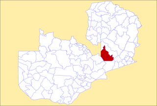
Serenje District is a district of Zambia, located in Central Province. The capital lies at Serenje. As of the 2022 Zambian Census, the district had a population of 158,192 people. It consists of two constituencies, namely Serenje and Muchinga. The district contains Lake Lusiwasi.

Chingola District is a district of Zambia, located in Copperbelt Province. The capital lies at Chingola. As of the 2022 Zambian Census, the district had a population of 299,936 people. It is divided into two constituencies, namely Chingola constituency and Nchanga constituency.

Kitwe District is a district of Zambia, located in Copperbelt Province. The capital is Kitwe. As of the 2022 Zambian Census, the district had a population of 661,901 people.

Luangwa District is a district of Zambia, located in Lusaka Province. As of the 2022 Zambian Census, the district had a population of 35,933 people.

Livingstone District is a district of Zambia, located in Southern Province. The capital lies at Livingstone. As of the 2022 Zambian Census, the district had a population of 177,393 people. Its border with Zimbabwe is formed by the Zambezi River and Victoria Falls. Although most people live in Livingstone, other villages include Jinga Jinga in the north and Simonga in the southwest.

Lundazi District is a district of Zambia, located in Eastern Province. The capital lies at Lundazi. As of the 2000 Zambian Census, the district had a population of 236,833 people. In 2018, Lundazi district was divided into 3 districts by the Government of the Republic of Zambia to enable rural development. The majority of the ethnic group is Tumbuka (99.9%).

Hwange District is an administrative district in northwestern Zimbabwe, in southern Africa.

Muchinga Province is one of the ten provinces of Zambia. It is located in the northeast of the country and borders with Tanzania in the north, Malawi in the east, Eastern Province in the south, Central Province in the southwest, Luapula Province in the west, and Northern Province in the northwest. The administrative center of the province is Chinsali.

Sioma District is a district of Zambia, located in Western Province on the west bank of the Zambezi River. The capital lies at Sioma.
