 |
|---|
Zambezi West is a constituency of the National Assembly of Zambia. [1] It covers the western part of Zambezi and the town of Kangano in Zambezi District of North-Western Province.
| |
|---|
Zambezi West is a constituency of the National Assembly of Zambia. [1] It covers the western part of Zambezi and the town of Kangano in Zambezi District of North-Western Province.

Zambia, officially the Republic of Zambia, is a landlocked country at the crossroads of Central, Southern and East Africa. It is typically referred to being in South-Central Africa or Southern Africa. It is bordered to the north by the Democratic Republic of the Congo, Tanzania to the north-east, Malawi to the east, Mozambique to the southeast, Zimbabwe and Botswana to the south, Namibia to the southwest, and Angola to the west. The capital city of Zambia is Lusaka, located in the south-central part of Zambia. The population is concentrated mainly around Lusaka in the south and the Copperbelt Province to the north, the core economic hubs of the country.

The Zambezi is the fourth-longest river in Africa, the longest east-flowing river in Africa and the largest flowing into the Indian Ocean from Africa. Its drainage basin covers 1,390,000 km2 (540,000 sq mi), slightly less than half of the Nile's. The 2,574 km (1,599 mi) river rises in Zambia and flows through eastern Angola, along the north-eastern border of Namibia and the northern border of Botswana, then along the border between Zambia and Zimbabwe to Mozambique, where it crosses the country to empty into the Indian Ocean.

Victoria Falls is a waterfall on the Zambezi River, located on the border between Zambia and Zimbabwe. It is one of the world's largest waterfalls, with a width of 1,708 m (5,604 ft). Its region is inhabited by several unique species of plants and animals.

The Zambezi Region is one of Namibia's fourteen regions, situated in the north-eastern part of the country along the Zambezi River where it gets it's name from. The region's capital is the town of Katima Mulilo. The Katima Mulilo Airport is 18 kilometres south-west of the town, while the village of Bukalo is located 43 kilometres south-east of Katima Mulilo. Formerly known as the Caprivi Region until 2013, it has eight electoral constituencies and a population of 142,373 according to the 2023 census.

The Luangwa River is one of the major tributaries of the Zambezi River, and one of the four biggest rivers of Zambia. The river generally floods in the rainy season and then falls considerably in the dry season. It is one of the biggest unaltered rivers in Southern Africa and the 52,000 square kilometres (20,000 sq mi) that make up the surrounding valley are home to abundant wildlife.

Western Province is one of the 10 provinces in Zambia and encompasses most of the area formerly known as Barotseland. The capital is Mongu, and together with the neighbouring town of Limulunga, Mongu is treated as the capital of Barotseland.

Chinyingi is a Capuchin mission and hospital in the sparsely populated North-Western Province of Zambia, on the west bank of the Zambezi River. An estimated 6000 people live within a seven kilometer radius of the Chinyingi mission. The mission's hospital, Chinyingi Mission Hospital, serves the local community with a 52-bed hospital and several health outreach programs, providing everything from first aid to services for people with HIV/AIDS AIDS, which affects some 25% of Zambia's population. The mission also operates a school.

The Kabompo River is one of the main tributaries of the upper Zambezi River. It flows entirely in Zambia, rising to the east of the source of the Zambezi, in North-Western Province along the watershed between the Zambezi and Congo river basins which also forms the border between Zambia and DR Congo. It is the second deepest river in Africa and one of the top five in the world.

Sesheke is a border town in the Western Province of Zambia, in a district of the same name. It lies on the northern bank of the Zambezi River which forms the border with Namibia's Caprivi Strip at that point.
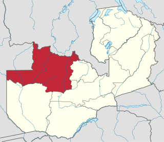
North-Western Province is one of ten Provinces of Zambia. It covers an area of 125,826 km2 (48,582 sq mi), has a population of 1,278,357 and a population density of 20 per square kilometre as of 2021. It is the most sparsely populated province in the country. The provincial capital is Solwezi. The literacy rate stood at 63 per cent in 2010 against a national average of 70.2 per cent. The rural population constituted 77.45%, while the urban population was 22.55%. North-Western Province is bordered along Angola in the west, the Democratic Republic of Congo in the north, Copperbelt Province in the east, Central in the south-east, and Western Province in the south-west.
The biomes and ecoregions in the ecology of Zambia are described, listed and mapped here, following the World Wildlife Fund's classification scheme for terrestrial ecoregions, and the WWF freshwater ecoregion classification for rivers, lakes and wetlands. Zambia is in the Zambezian region of the Afrotropical biogeographic realm. Three terrestrial biomes are well represented in the country . The distribution of the biomes and ecoregions is governed mainly by the physical environment, especially climate.
Zambia, officially known as the Republic of Zambia, is a landlocked country in Southern Africa. The neighbouring countries are the Democratic Republic of the Congo to the north, Tanzania to the north-east, Malawi to the east, Mozambique, Zimbabwe, Botswana, and Namibia to the south, and Angola to the west. The capital city is Lusaka, located in the southeast of the country. The population is concentrated mainly around the capital and the Copperbelt to the northwest.

Shangombo District with headquarters at Shangombo is located in Zambia. As of the 2010 Zambian Census, the district had a population of 84,070 people. This population is a combined figure with the newly created district of Sioma which was created by halving the primary district. The western part of the half retains the name Shangombo while the eastern part is called Sioma District.

Sesheke District is one of the sixteen (16) districts in Western Province of Zambia. Lying 300km south of the provincial capital, Mongu and 190km from Livingstone, the nations tourist capital, the district shares borders with Sioma in the west, Senanga and Mulobezi in the north-east and Mwandi in the east. The district also shares international border with Namibia south and Angola in south-west. The capital lies at Sesheke. As of the 2000 Zambian Census, the district had a population of 78,169 people. It contains Sioma Ngwezi National Park and contains part of the Zambezi River, which forms Zambia's border with Namibia.

Zambezi District is a district of Zambia, located in North-Western Province. The capital lies at Zambezi. As of the 2000 Zambian Census, the district had a population of 64,963 people. It consists of two constituencies, namely Zambezi West and Zambezi East.

Mkushi South is a constituency of the National Assembly of Zambia. It covers the towns of Chafung, Chingobe and Mboroma in Luano District of Central Province.
The M10 road is a road in Zambia. It goes from Livingstone, through Sesheke and Senanga, to Mongu. The road is approximately 508 kilometres and follows the Zambezi River for its entire length.
The T5 is a trunk road in Zambia. It connects Chingola in the Copperbelt Province with Solwezi and Mwinilunga in the North-Western Province. The route extends to end at the Jimbe border post with Angola. It is the only other road after the M18 road that connects the towns of the North-Western and Copperbelt provinces and is currently the main route motorists use to reach Angola from Zambia. The section of the road from Chingola to Mutanda is a toll road.
The M8 road is a road in the North-Western Province of Zambia. It connects Mutanda in Solwezi District with Zambezi Town via Mufumbwe, Manyinga & Kabompo.
Zambezi East is a constituency of the National Assembly of Zambia. It covers the eastern part of Zambezi and the towns of Chikomo, Chitongo, Kakeki, Muzaza, Nyakawanda and Samahamba in Zambezi District of North-Western Province.