 |
|---|
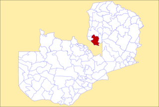
Mansa Central is a constituency of the National Assembly of Zambia. [1] It covers the southern part of Mansa and a rural area to the south of the city in Mansa District of Luapula Province.
| |
|---|
Mansa Central is a constituency of the National Assembly of Zambia. [1] It covers the southern part of Mansa and a rural area to the south of the city in Mansa District of Luapula Province.

Mansa is the capital of the Luapula Province of Zambia, and headquarters of Mansa District. It takes its name from the local Chief Mansa and the small Mansa River which flows west to the Luapula River. During British rule the city was named Fort Rosebery.

Luapula Province is one of Zambia's ten provinces located in the northern part of the country. Luapula Province is named after the Luapula River and its capital is Mansa. As per the 2022 Zambian census, the Province had a population of 1,519,478, which accounted for 7.72 per cent of the total Zambian population.
The National Assembly is Zambia's unicameral legislative body. Between 1972 and 1990, Zambia was a one-party state with the United National Independence Party (UNIP) as the sole legal party.

The Catholic Church in Zambia is part of the worldwide Catholic Church, under the spiritual leadership of the Pope in Rome.

The ten provinces of Zambia are divided into a total of 116 districts as of 2018.
Mansa may refer to:
The Ministry of Health is a ministry in Zambia. Its head offices are located in Lusaka.
Milenge District with headquarters at Milenge, Zambia is the most southerly district in the Luapula Province and was carved out of Mansa District. As of the 2000 Zambian Census, the district had a population of 28,790 people. It is rural and undeveloped, lacking roads and infrastructure. Its southern boundary is the Luapula River which divides it from DR Congo and the district lies roughly between the Chembe Ferry to Mansa road in the west and the Kapalala Ferry to Samfya road in the east. A single dirt road runs through the central part of the district from Chembe in the west following the north-west bank of the Lwela River, passing through Milenge Boma, Milambo and Lwela Mission, eventually connecting to the provincial capital, Mansa in the north-west. Most of the population of the district lives along the shallow valley of the Lwela River. The district is gently undulating flat plateau with an elevation of about 1200 m, consisting of woodland and wooded grassland interspersed with dambos.

The following outline is provided as an overview of and topical guide to Zambia:
Zambia, officially known as the Republic of Zambia, is a landlocked country in Southern Africa. The neighbouring countries are the Democratic Republic of the Congo to the north, Tanzania to the north-east, Malawi to the east, Mozambique, Zimbabwe, Botswana, and Namibia to the south, and Angola to the west. The capital city is Lusaka, located in the southeast of the country. The population is concentrated mainly around the capital and the Copperbelt to the northwest.

Mansa District with headquarters at Mansa is a district located in Luapula Province. As of the 2000 Zambian Census, the district had a population of 179,749 people. It consists of two constituencies, namely Mansa Central and Bahati.

Nchelenge District is a district of Zambia, located in the Luapula Province. The capital lies at Nchelenge. As of the 2000 Zambian Census, the district had a population of 111,119 people.

Mansa Airport is an airport serving Mansa, a city in the Luapula Province in Zambia. The airport is 4 kilometres (2.5 mi) north of the city.

Harry Kalaba is a Zambian politician and the current president for the Citizens First Party. He had served as Minister of Foreign Affairs of Zambia from March 2014 to January 2018. He is a former member of Patriotic Front. He served as the Member of Parliament for Bahati from August 2011 to February 2019.

Chitalu Chilufya is a Zambian physician and politician. He is currently a Member of the National Assembly for Mansa Central. He was Minister of Health from August 2016 to January 2021.
Bahati is a constituency of the National Assembly of Zambia. It covers the northern part of Mansa and a rural area to the north of the city in Mansa District of Luapula Province.
The M3 road is a road in northern Zambia that connects Kasama in the Northern Province with the Congo Pedicle border at Chembe in the Luapula Province via Luwingu and Mansa. The road contains two tollgates between Kasama and Mansa.
The M13 is a road in the Luapula Province of Zambia that connects Chipili with Kawambwa.