 |
|---|
Mporokoso is a constituency of the National Assembly of Zambia. [1] It covers the towns of Mporokoso and Mukunsa in Mporokoso District of Northern Province.
| |
|---|
Mporokoso is a constituency of the National Assembly of Zambia. [1] It covers the towns of Mporokoso and Mukunsa in Mporokoso District of Northern Province.
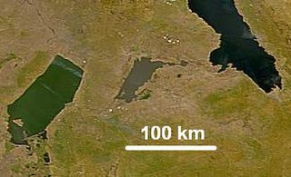
Lake Mweru Wantipa or Mweru-wa-Ntipa meaning "muddy lake" is a lake and swamp system in the Northern Province of Zambia. It has been regarded in the past as something of mystery, displaying fluctuations in water level and salinity which were not entirely explained by variation in rainfall levels; it has been known to dry out almost completely. This is compounded by its remoteness and it not receiving the same attention from geographers and geologists as its larger and more accessible neighbours, Lake Tanganyika, 25 km east, and Lake Mweru, 40 km west, with which its name is sometimes confused.
Luangwa may refer to:
The Bangweulu Block is a cratonic unit that forms part of the Congo craton of central Africa. The Bangweulu Block however consists of Palaeoproterozoic granitoids and volcanics, and is overlain by a Palaeoproterozoic continental sedimentary succession, the Mporokoso Group, and does not preserve much direct evidence of Archaean protoliths.
The Mporokoso Group is the name given to a sedimentary succession of fluvial, lacustrine and aeolian sandstones and minor siltstones occurring on the Bangweulu Block of northern Zambia.
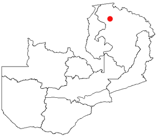
Mporokoso is a town in the Northern Province of Zambia, lying at an elevation of nearly 1500 m on the flat plateau about 75 km south east of Lake Mweru Wantipa and 100 km south-west of Lake Tanganyika. It is named for Chief Mporokoso a senior chief of the Bemba people whose palace is located at Chishamwamba close to the town. Mporokoso District is also one of the 12 administrative districts of the Northern Province.

The Kalungwishi River flows west in northern Zambia into Lake Mweru. It is known for its waterfalls, including the Lumangwe Falls, Kabweluma Falls, Kundabwika Falls and Mumbuluma Falls.

The ten provinces of Zambia are divided into a total of 116 districts as of 2018.
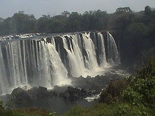
Lumangwe Falls on the Kalungwishi River in northern Zambia is the largest waterfall wholly within the country, with a height of 30-40 m and a width of 100-160 m. It is a block-type waterfall located between the Luapula and Northern Provinces. The main bedrock is interbedded quartzite with layers of red siltstone.

Nsumbu National Park lies on the western shore of Lake Tanganyika near its southern extremity, in Zambia's Northern Province. It covers about 2000 km2 and has some 80 km of lake shore including four bays, and Nundo Head Peninsula.
Chief Mporokoso is a senior chieftainship of the Bemba people of Zambia, and a subordinate chief of Paramount Chief Chitimukulu. The chief's palace is located in the Northern Province town of Mporokoso named after the chieftainship.
Kabwe Central is a constituency of the National Assembly of Zambia. It covers part of Kabwe District in Central Province.
Zambia, officially known as the Republic of Zambia, is a landlocked country in Southern Africa. The neighbouring countries are the Democratic Republic of the Congo to the north, Tanzania to the north-east, Malawi to the east, Mozambique, Zimbabwe, Botswana, and Namibia to the south, and Angola to the west. The capital city is Lusaka, located in the southeast of the country. The population is concentrated mainly around the capital and the Copperbelt to the northwest.

Kaputa District is a district of Zambia, located in Northern Province. The capital lies at Kaputa. As of the 2000 Zambian Census, the district had a population of 87,233 people.

Mporokoso District is a district of Zambia, located in Northern Province. The capital lies at Mporokoso. As of the 2000 Zambian Census, the district had a population of 73,929 people.

Chisimba Falls, also Chishimba Falls is a series of waterfalls located in Kasama District, in the Northern Province of Zambia. The waterfalls host the Chishimba Hydroelectric Power Station. The scenic views around the falls, together with a museum under development, are major tourist attractions.

Lunte District is a district of Northern Province, Zambia. It was separated from Mporokoso District in 2017.
The M3 road is a road in northern Zambia that connects Kasama in the Northern Province with the Congo Pedicle border at Chembe in the Luapula Province via Luwingu and Mansa. The road contains two tollgates between Kasama and Mansa.
The M13 is a road in the Luapula Province of Zambia that connects Chipili with Kawambwa.