 |
|---|
Kabwe Central is a constituency of the National Assembly of Zambia. It covers part of Kabwe District in Central Province.
 |
|---|
Kabwe Central is a constituency of the National Assembly of Zambia. It covers part of Kabwe District in Central Province.
The constituency was established in 1926 as Northern, covering Broken Hill, Kasempa, Mkushi, Mwinilunga, Ndola and Solwezi. [1] In 1929 Abercorn, Chinsali, Isoka, Kasama, Luwingu, Mpika and Mporokoso were added to the constituency, whilst Kasempa, Ndola and Solwezi were transferred to the new Ndola constituency. [1]
In 1941 the constituency was renamed Broken Hill, covering only Broken Hill, Mkushi and Serenje, with the remaining settlements transferred to the new North-Eastern constituency. [1] It was reduced in size again in 1948, now covering only the urban area of Broken Hill and the northern part of the Broken Hill rural area. [1]
The constituency was renamed Kabwe in 1964, and became Kabwe Central in 2001.

Kapiri Mposhi is a Zambian town, seat of the Kapiri Mposhi District, Central Province. Located north of Lusaka, it stands on the Great North Road and is significant for the railway connection between Zambia Railways line from Kitwe to Lusaka and Livingstone and western terminal of the Tanzania-Zambia Railway Authority from Dar es Salaam since 1976.

Kabwe is the capital of the Zambian Central Province and the Kabwe District, with a population estimated at 202,914 at the 2010 census. Named Broken Hill until 1966, it was founded when lead and zinc deposits were discovered in 1902. Kabwe also has a claim to being the birthplace of Zambian politics as it was an important political centre during the colonial period.

Central Province is one of Zambia's ten provinces. The provincial capital is Kabwe, which is the home of the Mulungushi Rock of Authority. Central Province has an area of 94,394 km (58,654 mi). It borders eight other provinces and has eleven districts. The total area of forest in the province is 9,095,566 ha, and it has a national park and three game management areas. The first mine in the region was opened up in 1905 making the then Broken Hill town the first mining town. In 1966, he town's name was reverted to its indigenous name - Kabwe meaning 'ore' or 'smelting'.

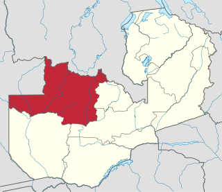
North-Western Province is one of ten Provinces of Zambia. It covers an area of 125,826 km2 (48,582 sq mi), has a population of 727,044 and a population density of 5.80 per square kilometre as of 2010. It is the most sparsely populated province in the country. The provincial capital is Solwezi. The literacy rate stood at 63 per cent against a national average of 70.2 per cent. The rural population constituted 77.45%, while the urban population was 22.55%. North-Western Province is bordered along Angola in the west, the Democratic Republic of Congo in the north, Copperbelt Province in the east, Central in the south-east, and Western Province in the south-west.

The Catholic Church in Zambia is part of the worldwide Catholic Church, under the spiritual leadership of the Pope in Rome. There are over about three million Catholics in the country, or 21% of the total population. There are ten dioceses, including two archdioceses.
The Archdiocese of Lusaka is a Latin Church ecclesiastical territory or archdiocese of the Catholic Church in Zambia, where it is also considered its national primatial see.
This article gives lists of the National Monuments and other historic sites of Zambia, with a one- or two-line description providing links to details given on other pages.

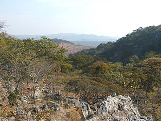
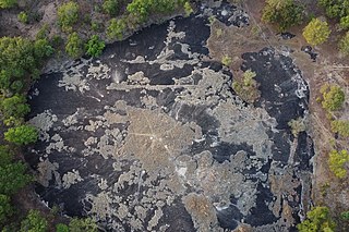
Mulungushi Rock of Authority, also known as Mulungushi Rock, is a kopje in the Central Province of Zambia associated with major political gatherings and speeches. Situated near the Mulungushi River north of Kabwe, it was first used in 1958 for a rally of the Zambian African National Congress and then in 1960 for the first conference of the newly-formed United National Independence Party. Since 1964, it has been regularly used by political parties for their annual conventions and meetings. A national symbol, the Rock of Authority is called "the birthplace of Zambian independence".
The Northern Rhodesia Police was the police force of the British-ruled protectorate of Northern Rhodesia.

General elections were held in Northern Rhodesia on 31 August 1929. One issue in the elections was the proposed amalgamation of the colony with neighbouring Southern Rhodesia.

Mkushi South is a constituency of the National Assembly of Zambia. It covers the towns of Chafung, Chingobe and Mboroma in Luano District of Central Province.

General elections were held in Northern Rhodesia on 29 September 1944.

General elections were held in Northern Rhodesia on 29 August 1941. All five Labour Party candidates won their seats.

Nkana is a constituency of the National Assembly of Zambia. It covers the western part of the city of Kitwe in Kitwe District, including the city centre and the suburb of Nkana.

The T2 is a trunk road in Zambia. The road runs from the Tunduma border with Tanzania via Mpika, Kabwe and Lusaka to the Chirundu border with Zimbabwe. The road is the longest route of the country, as it is approximately 1,155 kilometres (718 mi). The route from Mpika to Kafue is a toll road. The route from Tanzania to Lusaka is Zambia's Great North Road and is part of the Tanzam Highway.

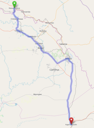
The T3 is a Trunk Road in Zambia. The road runs from Kapiri Mposhi via Ndola, Kitwe and Chingola to Kasumbalesa on the border with DR Congo. The entire route is a toll road.
The T5 is a trunk road in Zambia. It connects Chingola in the Copperbelt Province with Solwezi and Mwinilunga in the North-Western Province. The Route extends to end at a border with Angola. It is the only other road after the M18 Road that connects the towns of the North-Western and Copperbelt provinces and is currently one of the main routes motorists use to reach Angola from Zambia. The first section of the road is a toll road.
The M18 Road is a road in Zambia that connects Kitwe in the Copperbelt Province with Kasempa in the North-Western Province via Kalulushi and Lufwanyama. It is the only other road after the T5 Road that connects the towns of the North-Western and Copperbelt provinces. The section from Kitwe to Kalulushi is designated as the M7 Road while the remainder of the route from Kalulushi westwards is designated as the M18 Road on Zambia's road network.