 |
|---|
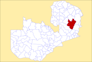
Feira is a constituency of the National Assembly of Zambia. [1] It covers the towns of Jeki, Kapoche, Katemo, Katondwe and Luangwa (previously known as Feira) in Luangwa District of Lusaka Province.
| |
|---|
Feira is a constituency of the National Assembly of Zambia. [1] It covers the towns of Jeki, Kapoche, Katemo, Katondwe and Luangwa (previously known as Feira) in Luangwa District of Lusaka Province.

The Luangwa River is one of the major tributaries of the Zambezi River, and one of the four biggest rivers of Zambia. The river generally floods in the rainy season and then falls considerably in the dry season. It is one of the biggest unaltered rivers in Southern Africa and the 52,000 square kilometres (20,000 sq mi) that make up the surrounding valley are home to abundant wildlife.

Chipata is a city and administrative centre of the Eastern Province of Zambia and Chipata District. It was declared the 5th city of the country, after Lusaka, Ndola, Kitwe and Livingstone, by President Edgar Lungu on 24 February 2017. The city has undergone rapid economic and infrastructure growth in the years, leading up to city status.
Luangwa may refer to:
North Luangwa National Park is a national park in Zambia, the northernmost of the three in the valley of the Luangwa River. Founded as a game reserve in 1938, it became a national park in 1972 and now covers 4,636 km².

South Luangwa National Park is in eastern Zambia, the southernmost of three national parks in the valley of the Luangwa River. It is a world-renowned wildlife haven which is known to locals simply as "the South Park." Concentrations of game along the meandering Luangwa River and its lagoons are amongst the most intense in Africa. The river teems with hippo and crocodile and provides a lifeline for one of the greatest diversities of habitat and wildlife, supporting more than 60 species of mammals and over 400 species of birds. It marks the end of the Great Rift Valley.
The Nsenga, not to be confused with the Senga, are a Bantu ethnic tribe of Zambia and Mozambique. In Zambia, they are found in two districts of Eastern province namely Nyimba and Petauke. They are also dialects with the Nsenga Luzi of the Luangwa valley in Chief Nyalugwe, Mboloma and Lwembe and the Chikunda of Luangwa Boma (Feira). Their Senior Chief is Kalindawalo M'ndikula, who resides in Merwe 10 kilometers from Petauke Boma. The following are Nsenga Chiefs: Chiefs Mwape, Nyamphande, Nyanje, Mumbi, Sandwe, Nyalugwe, Ndake, Senior Chief Lwembe, Senior Chief Mboloma and Mwanjaw'anthu. They are well known for their culture and artwork which includes bead work and basketry. They also grow groundnuts, maize, millet and sorghum for consumption and cotton (Thonje) as cash crop, and are popular for their Mbewa (Mice), a practice which they are often teased for. The Nsenga language spoken by people of this tribe has been adopted by many groups in Zambia and diluted to Zambia’s widely spoken language Chinyanja or Nyanja.
Zumbo is the westernmost town in Mozambique, on the Zambezi River. Lying on the north-east bank of the Zambezi-Luangwa River confluence, it is a border town, with Zambia across the Luangwa River and Zimbabwe diagonally across the Zambezi and 2 km upstream. In 2005, Zumbo had a population of 33,000, and it lies in the Zumbo District of Tete Province.

The Great East Road is a major road in Zambia and the main route linking its Eastern Province with the rest of the country. It is also the major link between Zambia and Malawi and between Zambia and northern Mozambique. However, the route does not carry as much traffic as many of the other regional arterial roads and between the main cities it serves, Lusaka and Chipata, it passes through rural and wilderness areas. In Lusaka the road forms the main arterial road for the eastern suburbs. The entire route from Lusaka to Chipata and the border with Malawi is designated the T4 road on Zambia's road network.

Lusaka Province is one of the ten provinces of Zambia. Its capital is Lusaka, which is also the national capital. It is the smallest province in Zambia, with an area of 21,896 km2. Lusaka is also Zambia's most populated and most densely populated province, with a population of 3,079,964 and density of 140 persons per km2 as of 2022. It is the most urban province, with the most doctors and fewest malaria-related incidents. The province is bordered by Zimbabwe and Mozambique, and separated by the Lower Zambezi National Park.
Luambe National Park is located in the Eastern Province of Zambia. The park is situated north-east of the famous South Luangwa National Park, and south of the North Luangwa National Park. Like its neighbours, it is located in the Luangwa River rift valley.

Mfuwe Airport is an airport serving Mfuwe, a diffuse settlement in Mambwe District in the Eastern Province in Zambia. It serves the tourism industry based on the nearby South Luangwa National Park and other wildlife areas in the Luangwa Valley. It is one of four international airports in Zambia, with seasonal international flights.
Luangwa is a town in Zambia, at the confluence of the Luangwa and Zambezi Rivers, which was called Feira until 1964. It is headquarters of a district of the same name in Lusaka Province.

The wildlife of Zambia refers to the natural flora and fauna of Zambia. This article provides an overview, and outline of the main wildlife areas or regions, and compact lists of animals focusing on prevalence and distribution in the country rather than on taxonomy. More specialized articles on particular groups are linked from here.
Feira may refer to:

The following outline is provided as an overview of and topical guide to Zambia:
Zambia, officially known as the Republic of Zambia, is a landlocked country in Southern Africa. The neighbouring countries are the Democratic Republic of the Congo to the north, Tanzania to the north-east, Malawi to the east, Mozambique, Zimbabwe, Botswana, and Namibia to the south, and Angola to the west. The capital city is Lusaka, located in the southeast of the country. The population is concentrated mainly around the capital and the Copperbelt to the northwest.

Luangwa District is a district of Zambia, located in Lusaka Province. As of the 2020 Zambian Census, the district had a population of 31,007 people.

Mambwe District is a district of Zambia, located in Eastern Province. Mambwe District inhabits the Luangwa Valley between the 13th and 14th parallel of south latitude. The Kunda name for this area is "Malambo''.
Mpika District is a district of Zambia, located in Muchinga Province. The capital lies at Mpika. As of the 2000 Zambian Census, the district had a population of 146,196 people. With the Luangwa River forming its eastern border, it has most of the South Luangwa National Park within its boundaries. It also contains the North Luangwa National Park.