 |
|---|
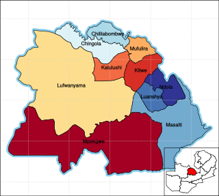
Lufwanyama is a constituency of the National Assembly of Zambia. It covers a large rural area in the Lufwanyama District of Copperbelt Province, including the town of Lufwanyama. [1]
 |
|---|
Lufwanyama is a constituency of the National Assembly of Zambia. It covers a large rural area in the Lufwanyama District of Copperbelt Province, including the town of Lufwanyama. [1]

Copperbelt Province is a province in Zambia which covers the mineral-rich Copperbelt, and farming and bush areas to the south. It was the backbone of the Northern Rhodesian economy during British colonial rule and fuelled the hopes of the immediate post-independence period, but its economic importance was severely damaged by a crash in global copper prices in 1973. The province adjoins the Haut-Katanga province of the Democratic Republic of the Congo, which is similarly mineral-rich.

Elections in Zambia take place within the framework of a multi-party democracy and a presidential system. The President and National Assembly are simultaneously elected for five-year terms.

The National Assembly is Zambia's unicameral legislative body. Between 1972 and 1990, Zambia was a one-party state with the United National Independence Party (UNIP) as the sole legal party.

The ten provinces of Zambia are divided into a total of 116 districts as of 2018.

Lufwanyama is a small town on the M18 road in the Copperbelt Province of Zambia.

The Speaker of the National Assembly of Zambia is a position established under Article 69(1) of the constitution. The Speaker is elected by members of the Assembly from anyone eligible to be elected to the National Assembly, but cannot be a sitting member.

Masaiti District is a district of Zambia, located in Copperbelt Province. The capital lies at Masaiti. As of the 2000 Zambian Census, the district had a population of 95,581 people. It is divided into two constituencies, namely Masaiti constituency and Kafulafuta constituency.

Mpongwe District is a district of Zambia, located in Copperbelt Province. The capital lies at Mpongwe. As of the 2010 Zambian Census, the district had a population of 93,380 people.

General elections were held in Zambia on 19 December 1968 to elect the National Assembly and President. The first post-independence polls saw incumbent Kenneth Kaunda retain his post as president, whilst his United National Independence Party, the only party to field candidates in all 105 constituencies, won 81 of the 105 seats in the National Assembly. Voter turnout was 82.5% in the parliamentary election, but 87.1% in the presidential election.

General elections were held in Zambia on 5 December 1973. They were the first elections held since the country was formally declared a one-party state in August, with the United National Independence Party (UNIP) as the only legally permitted party. UNIP leader Kenneth Kaunda was automatically elected to a third five-year term as President, and was confirmed in office via a referendum in which 88.8% of voters approved his candidacy. UNIP also won all 125 seats in the National Assembly. Voter turnout was 39% of the 1,746,107 registered voters for the presidential election, and 33% for the National Assembly election.

General elections were held in Zambia on 31 October 1991 to elect a President and National Assembly. They were the first multi-party elections since 1968, and only the second multi-party elections since independence in 1964. The United National Independence Party (UNIP), which had led the country since independence, was comprehensively beaten by the Movement for Multi-Party Democracy (MMD). Kenneth Kaunda, who had been president since independence, was defeated in a landslide by MMD challenger Frederick Chiluba in the presidential elections, whilst the MMD won 125 of the 150 elected seats in the expanded National Assembly. Voter turnout was 45%.
The T5 is a trunk road in Zambia. It connects Chingola in the Copperbelt Province with Solwezi and Mwinilunga in the North-Western Province. The route extends to end at the Jimbe border post with Angola. It is the only other road after the M18 road that connects the towns of the North-Western and Copperbelt provinces and is currently the main route motorists use to reach Angola from Zambia. The section of the road from Chingola to Mutanda is a toll road.
The M18 road is a road in Zambia that connects Kitwe in the Copperbelt Province with Kawana in the North-Western Province via Kalulushi and Lufwanyama. It is the only other road after the T5 road that connects the towns of the North-Western and Copperbelt provinces. The section from Kitwe to Kalulushi is designated as the M7 road while the route from Kalulushi westwards to Kasempa District is designated as the M18 road on Zambia's road network.

Nalolo is a constituency of the National Assembly of Zambia. It covers Nalolo District in Western Province.

Mulobezi is a constituency of the National Assembly of Zambia. It covers Mulobezi and surrounding areas in Mulobezi District of Western Province.

Sesheke is a constituency of the National Assembly of Zambia. It covers Sesheke and surrounding towns in Sesheke District of Western Province.

Nalikwanda is a constituency of the National Assembly of Zambia. It covers part of Mongu District in Western Province.

Magoye is a constituency of the National Assembly of Zambia. It covers the village of Magoye and surrounding areas in Mazabuka District of Southern Province.

Mangango is a constituency of the National Assembly of Zambia. It covers part of Kaoma District in Western Province.

Luena is a constituency of the National Assembly of Zambia. It covers Limulunga District in Western Province, including the town of Limulunga.