Solwezi is a town in Zambia. It is the provincial capital of the mineral-rich North-Western Province. Solwezi is also the administrative capital of Solwezi District, one of the eleven districts in the North-Western Province.

Chingola is a city in Zambia's Copperbelt Province, the country's copper-mining region, with a population of 216,626. It is the home of Nchanga Copper Mine, a deep-shaft high-grade content copper mining operation, which subsequently led to the development of two open pit operations, Chingola Open Pit and then Nchanga Open Pit.

The Kafue River is the longest river lying wholly within Zambia at about 1,576 kilometres (979 mi) long. Its water is used for irrigation and for hydroelectric power. It is the largest tributary of the Zambezi, and of Zambia's principal rivers, it is the most central and the most urban. More than 50% of Zambia's population live in the Kafue River Basin and of these around 65% are urban.

Ndola is the third largest city in Zambia and third in terms of size and population, with a population of 475,194, after the capital, Lusaka, and Kitwe, and the second largest in terms of infrastructure development after Lusaka. It is the industrial and commercial center of the Copperbelt, Zambia's copper-mining region, and capital of Copperbelt Province. It lies just 10 kilometres (6.2 mi) from the border with DR Congo. It is also home to Zambia's first modern stadium, the Levy Mwanawasa Stadium.

Copperbelt Province is a province in Zambia which covers the mineral-rich Copperbelt, and farming and bush areas to the south. It was the backbone of the Northern Rhodesian economy during British colonial rule and fuelled the hopes of the immediate post-independence period, but its economic importance was severely damaged by a crash in global copper prices in 1973. The province adjoins the Haut-Katanga province of the Democratic Republic of the Congo, which is similarly mineral-rich.

Chipata is a city and administrative centre of the Eastern Province of Zambia and Chipata District. It was declared the 5th city of the country, after Lusaka, Ndola, Kitwe and Livingstone, by President Edgar Lungu on 24 February 2017. The city has undergone rapid economic and infrastructure growth in the years, leading up to city status.
Hwange, originally known as Wankie, is a town in Zimbabwe, located in Hwange District, in Matabeleland North Province, in northwestern Zimbabwe, close to the international borders with Botswana and Zambia. It lies approximately 100 kilometres (62 mi), by road, southeast of Victoria Falls, the nearest large city. The town lies on the railway line from Bulawayo, Zimbabwe's second-largest city, to Victoria Falls. Hwange sits at an elevation of 770 metres (2,530 ft), above sea level.

Kitwe is the third largest city in terms of infrastructure development and second largest city in terms of size and population in Zambia. With a population of 517,543 Kitwe is one of the most developed commercial and industrial areas in the nation, alongside Ndola and Lusaka. It has a complex of mines on its north-western and western edges.
Mufulira is a town in the Copperbelt Province of Zambia. Mufulira means "Place of Abundance and Peace". The town developed around the Mufulira Copper Mine in the 1930s. The town also serves as the administrative capital of Mufulira District.
Chinhoyi, previously known as Sinoia during the colonial era, is a city in central northern Zimbabwe in the Makonde District. It has a population of 90,800 and is primarily a college town, although it was originally founded as an Italian group settlement scheme. The nearby Chinhoyi Caves and national park are a popular attraction.
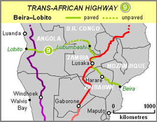
The Beira–Lobito Highway or TAH 9 is Trans-African Highway 9 in the transcontinental road network being developed by the United Nations Economic Commission for Africa (UNECA), the African Development Bank (ADB), and the African Union. The route has a length of 3,523 km (2,189 mi) crossing Angola, the most southerly part of the Democratic Republic of the Congo, Zambia, Zimbabwe, and central Mozambique.
Investrust Bank Plc., commonly known as Investrust Bank, is a commercial bank in Zambia. It is licensed by the Bank of Zambia, the central bank and national banking regulator.
Nakonde is a town in the Muchinga Province of Zambia, on the border with Tanzania. It is at the northern end of Zambia's Great North Road. It is the principal commercial and political headquarters of Nakonde District and the district headquarters are located here.

The T2 is a trunk road in Zambia. The road runs from the Tunduma border with Tanzania via Mpika, Kabwe and Lusaka to the Chirundu border with Zimbabwe. The road is the longest route of the country, as it is approximately 1,155 kilometres (718 mi). The route from Mpika to Kafue is a toll road. The route from Tanzania to Lusaka is Zambia's Great North Road and is part of the Tanzam Highway.
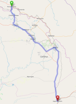
The T3 is a Trunk Road in Zambia. The road runs from Kapiri Mposhi via Ndola, Kitwe and Chingola to Kasumbalesa on the border with DR Congo. The entire route is a toll road.
The T5 is a trunk road in Zambia. It connects Chingola in the Copperbelt Province with Solwezi and Mwinilunga in the North-Western Province. The route extends to end at the Jimbe border post with Angola. It is the only other road after the M18 road that connects the towns of the North-Western and Copperbelt provinces and is currently the main route motorists use to reach Angola from Zambia. The section of the road from Chingola to Mutanda is a toll road.
Kasumbalesa is a town in Zambia that sits across the international border from the much larger town of Kasumbalesa, Democratic Republic of the Congo. It is a major crossing point for human traffic and cargo between the two countries.
The M4 road is a road in the Copperbelt Province of Zambia. The road connects the city of Ndola with the city of Mufulira and extends to connect Mufulira with the city of Kitwe. As it is a v-shaped route, the M4 road starts and ends at a junction with the T3 road.
The M18 road is a road in Zambia that connects Kitwe in the Copperbelt Province with Kasempa in the North-Western Province via Kalulushi and Lufwanyama. It is the only other road after the T5 road that connects the towns of the North-Western and Copperbelt provinces. The section from Kitwe to Kalulushi is designated as the M7 road while the route from Kalulushi westwards to Kasempa District is designated as the M18 road on Zambia's road network.
The M16 is a short 14-kilometre toll road in Kalulushi District, Copperbelt Province, Zambia that connects Kalulushi with Sabina.

