In some contexts the term Copperbelt may exclude the Congo entirely. Zambia's Copperbelt became a province soon after independence in 1964, when it was named "Western province". President Kenneth Kaunda changed the name to its present-day "Copperbelt province" in 1969. From the time of the Bantu expansion, both the Congo's Katanga and Zambia's Copperbelt regions have been called "Ilamba" or "Lambaland", after the Lamba people. Both provinces are rich in mineral wealth.
Prehistory
The Copperbelt was not inhabited before the arrival of the Lamba people from the Luba and Lunda kingdoms.[dubious–discuss] The Lamba settled at Lake Kashiba, and from there the Lamba kingdom spread eastward, northward, southward and westward.
History
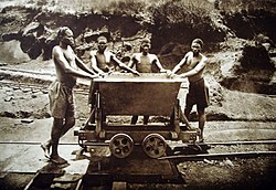
Rwandanmigrant workers in a Congolese copper mine, c.1920, during the Belgian colonial periodCopperbelt mining centersPre-colonial copper coin from the Katanga Province. These coins forming the Katanga Cross are no longer produced, but those remaining are used symbolically among traditional families for the payment of dowry (along with money and other goods).
The Western discovery of copper in Zambia is partly due to American scout Frederick Russell Burnham. In 1895 he led the Northern Territories (BSA) Exploration Co. expedition, which determined that major copper deposits existed in Central Africa.[2] Along the Kafue River in then-Northern Rhodesia, Burnham saw many similarities to copper deposits he had worked in the United States, and he encountered natives wearing copper bracelets.[3] In his report to the British South Africa Company Burnham said about the region:[4]
About 200 miles north of the Falls on the Incalla river, and twelve miles from the Kafukwe [now known as the Kafue River] and still on the high plateau is probably one of the greatest copper fields on the continent. The natives have worked this ore for ages, as can be seen by their old dumps, and they work it to-day. The field is very extensive, and reaches away to Katanga... The natives inhabiting this part of the country are skilled workmen, and have traded their handiwork with all comers, even as far afield as the Portuguese of the West Coast and the Arabs of the East. These natives, being miners and workers of copper and iron, and being permanently located in the ground, would give the very element needed in developing these fields.
The increasing use of copper bids fair to make it one of the most valuable products a country can have.... The copper mines of Montana and Arizona have proven of more value than the gold mines, regardless of the fact that the copper had to be hauled two thousand miles by rail to the seaboard, and the coal and coke to smelt it hauled hundreds of miles to the mines. So far as natural difficulties are concerned, this northern field can be fed from the coal deposits of the valley of the Zambezi [Burnham had previously discovered massive coal fields at Hwange], and the product shipped to the East Coast at a less expense than the product of Montana and Arizona can be laid on the dock at New York.
The Katanga Supergroup nonconformably overlies the 883 Ma Nchanga Granite.[7] The Katangan Supergroup is divided into four metasedimentary series, from the oldest siliclastic and dolomitic Roan Group conglomerates, sandstones, and shales, to Nguba Group of mostly carbonates and carbon-rich shales, to the youngest, upper most Kundelungu Group including glacial metasediments and a cap carbonate.[7][8]
The Katanga Supergroup correlates with rocks of the Makuti Group in other parts of the DR Congo.[9]
↑Juang, Richard M. (2008). Africa and the Americas: culture, politics, and history: a multidisciplinary encyclopedia, Volume 2 Transatlantic relations series. ABC-CLIO. p.1157. ISBN1-85109-441-5.
↑Heinrich, E. Wm. (1958). Mineralogy and Geology of Radioactive Raw Materials. New York: McGraw-Hill Book Company, Inc. p.298.
123Master, S; C. Rainaud; R.A. Armstrong; D. Phillips; L.J. Robb (2005). "Provenance ages of the Neoproterozoic Katanga Supergroup (Central African Copperbelt), with implications for basin evolution". Journal of African Earth Sciences. 42: 41–60. doi:10.1016/j.jafrearsci.2005.08.005.
↑Rainaud, C.; S. Master; R.A. Armstrong; L.J. Robb (2005). "Geochronology and nature of the Palaeoproterozoic basement in the Central African Copperbelt (Zambia and the Democratic Republic of Congo), with regional implications". Journal of African Earth Sciences. 42: 1–31. doi:10.1016/j.jafrearsci.2005.08.006.
↑Hunter, D.R., ed. (1981). Precambrian of the Southern hemisphere. Amsterdam: Elsevier Scientific. ISBN978-0-444-41862-3.[pageneeded]
This page is based on this Wikipedia article Text is available under the CC BY-SA 4.0 license; additional terms may apply. Images, videos and audio are available under their respective licenses.