Related Research Articles

The Andes, Andes Mountains or Andean Mountain Range are the longest continental mountain range in the world, forming a continuous highland along the western edge of South America. The range is 8,900 km (5,530 mi) long and 200 to 700 km wide and has an average height of about 4,000 m (13,123 ft). The Andes extend from South to North through seven South American countries: Argentina, Chile, Bolivia, Peru, Ecuador, Colombia, and Venezuela.

In geology, a fault is a planar fracture or discontinuity in a volume of rock across which there has been significant displacement as a result of rock-mass movements. Large faults within Earth's crust result from the action of plate tectonic forces, with the largest forming the boundaries between the plates, such as the megathrust faults of subduction zones or transform faults. Energy release associated with rapid movement on active faults is the cause of most earthquakes. Faults may also displace slowly, by aseismic creep.

The Ring of Fire is a tectonic belt of volcanoes and earthquakes.

The Chilean Coastal Range is a mountain range that runs from north to south along the Pacific coast of South America parallel to the Andean Mountains, extending from Morro de Arica in the north to Taitao Peninsula, where it ends at the Chile Triple Junction, in the south. The range has a strong influence on the climate of Chile since it produces a rain shadow to the east. Because of this the vegetation growing on the seaward slopes is much more exuberant than in the interior. Compared to the coastal lowlands and the Intermediate Depression, it is sparsely populated with land use varying from protected areas to grazing and silviculture. The range is present in all Chilean regions, except for Coquimbo Region and Magallanes Region.

The Liquiñe-Ofqui Fault is major geological fault that runs a length of roughly 1,200 kilometres (750 mi) in a NNE-SSW orientation and exhibits current seismicity. It is located in the Chilean Northern Patagonian Andes. It is a dextral intra-arc strike-slip fault. Most large stratovolcanoes of the Southern Volcanic Zone of the Andes are aligned by the fault which allows for the movement of magma and hydrothermal fluids.

Tacora is a stratovolcano located in the Andes of the Arica y Parinacota Region of Chile. Near the border with Peru, it is one of the northernmost volcanoes of Chile. It is part of the Central Volcanic Zone in Chile, one of the four volcanic belts of the Andes. The Central Volcanic Zone has several of the highest volcanoes in the world. Tacora itself is a stratovolcano with a caldera and a crater. The youngest radiometric age is 50,000 years ago and it is heavily eroded by glacial activity.
The Cordillera Domeyko is a mountain range of the Andes located in northern Chile, west of Salar de Atacama. It runs north-south for approximately 600 km, parallel to the main chain. The mountain range marks the eastern border of the flat parts of Atacama Desert. The western border of Cordillera Domeyko is characterized by a inland cliffs and a sharp topographic transition known as El Bordo Escarpment. El Bordo Escarpment contain the main rock outcrops of the Purilactis Group, which make up much of the mountain range.
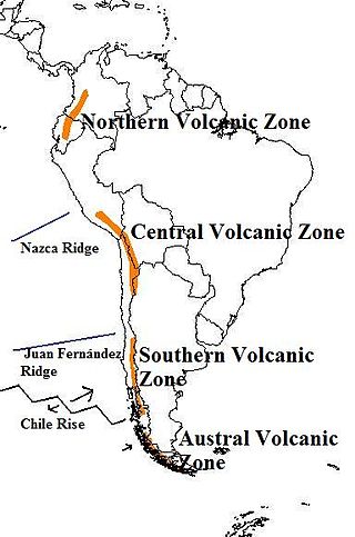
The Andean Volcanic Belt is a major volcanic belt along the Andean cordillera in Argentina, Bolivia, Chile, Colombia, Ecuador, and Peru. It is formed as a result of subduction of the Nazca Plate and Antarctic Plate underneath the South American Plate. The belt is subdivided into four main volcanic zones which are separated by volcanic gaps. The volcanoes of the belt are diverse in terms of activity style, products, and morphology. While some differences can be explained by which volcanic zone a volcano belongs to, there are significant differences within volcanic zones and even between neighboring volcanoes. Despite being a type location for calc-alkalic and subduction volcanism, the Andean Volcanic Belt has a broad range of volcano-tectonic settings, as it has rift systems and extensional zones, transpressional faults, subduction of mid-ocean ridges and seamount chains as well as a large range of crustal thicknesses and magma ascent paths and different amounts of crustal assimilations.

The geology of Chile is a characterized by processes linked to subduction, such as volcanism, earthquakes, and orogeny. The building blocks of Chile's geology were assembled during the Paleozoic Era when Chile was the southwestern margin of the supercontinent Gondwana. In the Jurassic, Gondwana began to split, and the ongoing period of crustal deformation and mountain building known as the Andean orogeny began. In the Late Cenozoic, Chile definitely separated from Antarctica, and the Andes experienced a significant rise accompanied by a cooling climate and the onset of glaciations.
Salar de Pedernales is a large salt flat in the Atacama Region of Chile. It lies east of the Cordillera Domeyko at an elevation of 3,370 metres (11,060 ft). The salt flat has an irregular shape and consists mostly of gypsum and rock salt, with an area of 0.6 square kilometres (0.23 sq mi)-1.1 square kilometres (0.42 sq mi) covered by open water. During the late Pleistocene, the climate was wetter and thus open water covered a much larger area of Salar de Pedernales.

The Andean orogeny is an ongoing process of orogeny that began in the Early Jurassic and is responsible for the rise of the Andes mountains. The orogeny is driven by a reactivation of a long-lived subduction system along the western margin of South America. On a continental scale the Cretaceous and Oligocene were periods of re-arrangements in the orogeny. The details of the orogeny vary depending on the segment and the geological period considered.

The geology of Bolivia comprises a variety of different lithologies as well as tectonic and sedimentary environments. On a synoptic scale, geological units coincide with topographical units. The country is divided into a mountainous western area affected by the subduction processes in the Pacific and an eastern lowlands of stable platforms and shields. The Bolivian Andes is divided into three main ranges; these are from west to east: the Cordillera Occidental that makes up the border to Chile and host several active volcanoes and geothermal areas, Cordillera Central once extensively mined for silver and tin and the relatively low Cordillera Oriental that rather than being a range by its own is the eastern continuation of the Central Cordillera as a fold and thrust belt. Between the Occidental and Central Cordillera the approximately 3,750-meter-high Altiplano high plateau extends. This basin hosts several freshwater lakes, including Lake Titicaca as well as salt-covered dry lakes that bring testimony of past climate changes and lake cycles. The eastern lowlands and sub-Andean zone in Santa Cruz, Chuquisaca, and Tarija Departments was once an old Paleozoic sedimentary basin that hosts valuable hydrocarbon reserves. Further east close to the border with Brazil lies the Guaporé Shield, made up of stable Precambrian crystalline rock.

Domeyko Glacier is a glacier flowing southeast into Mackellar Inlet, Admiralty Bay, King George Island, in the South Shetland Islands. It was named by the Polish Antarctic Expedition, 1980, after Ignacy Domeyko, a Polish-born explorer of the Andes and sometime Professor of Chemistry and Mineralogy, and Rector, of the University of Chile, Santiago.
The Reigolil-Pirihueico Fault is a second-order geological fault located in the Chilean and Argentine Andes. As the name implies, it runs from Pirihueico Lake to Reigolil Valley. Reigolil-Pirihueico Fault run in north–south direction and is roughly parallel to the larger Liquiñe-Ofqui Fault, which is located 15 to 20 km west of it to which it is considered a branch of. East of Reigolil-Pirihueico Fault, close or along the Argentina-Chile boundary, are a string of volcanoes pliocene to quaternary volcanoes: Lanín, Pirihueico, Huanquihué, Quelguenco and Chihuío.

The El Tigre Fault is a 120 km long, roughly north-south trending, major strike-slip fault located in the Western Precordillera in Argentina. The Precordillera lies just to the east of the Andes mountain range in South America. The northern boundary of the fault is the Jáchal River and its southern boundary is the San Juan River. The fault is divided into three sections based on fault trace geometry, Northern extending between 41–46 km in length, Central extending between 48–53 km in length, and Southern extending 26 km in length. The fault displays a right-lateral (horizontal) motion and has formed in response to stresses from the Nazca Plate subducting under the South American Plate. It is a major fault with crustal significance. The Andes Mountain belt trends with respect to the Nazca Plate/South American Plate convergence zone, and deformation is divided between the Precordilleran thrust faults and the El Tigre strike-slip motion. The El Tigre Fault is currently seismically active.

La Negrillar is a volcanic cone and associated lava flow in Chile. It covers 16 square kilometres (6.2 sq mi) on the southwestern margin of the Atacama basin. It erupted basalts and andesite and its flows and cones are well preserved. Radiometric dating has yielded ages of 1.4 ± 0.5 and 0.54 ± 0.5 million years. It is one of several mafic centres in the region located along fault systems.
Jotabeche is a Miocene-Pliocene caldera in the Atacama Region of Chile. It is part of the volcanic Andes, more specifically of the extreme southern end of the Central Volcanic Zone (CVZ). This sector of the Andean Volcanic Belt contains about 44 volcanic centres and numerous more minor volcanic systems, as well as some caldera and ignimbrite systems. Jotabeche is located in a now inactive segment of the CVZ, the Maricunga Belt.
The Romeral Fault System is a megaregional system of major parallel and anastomosing faults in the Central Ranges of the Colombian Andes and the Cauca, Amagá, and Sinú-San Jacinto Basins. The system spans across ten departments of Colombia, from northeast to south Bolívar, Sucre, Córdoba, Antioquia, Caldas, Risaralda, Quindío, Valle del Cauca, Cauca and Nariño. The fault zone extends into Ecuador where it is known as the Peltetec Fault System. The in detail described part of the Romeral Fault System south of Córdoba has a total length of 697.4 kilometres (433.3 mi) with a cumulative length of 1,787.9 kilometres (1,110.9 mi) and runs along an average north to south strike of 017.6 ± 16, cross-cutting the central-western portion of Colombia.

Salar de Punta Negra is a saltpan in the Antofagasta Region of Chile with a surface area of about 230 square kilometres (89 sq mi). It is surrounded by deposits left by dry valleys that descend the Western Cordillera. These dry valleys, from mountains such as the Llullaillaco volcano, carry water only occasionally. More permanent sources of water, in the form of springs, also exist at Salar de Punta Negra.

Oblique subduction is a form of subduction for which the convergence direction differs from 90° to the plate boundary. Most convergent boundaries involve oblique subduction, particularly in the Ring of Fire including the Ryukyu, Aleutian, Central America and Chile subduction zones. In general, the obliquity angle is between 15° and 30°. Subduction zones with high obliquity angles include Sunda trench and Ryukyu arc.
References
- 1 2 Hoffmann-Rothe, Arne (2006). "Oblique Convergence along the Chilean Margin: Partitioning, Margin-Parallel Faulting and Force Interaction at the Plate Interface". In Oncken, Onno (ed.). The Andes: Active Subduction Orogeny. Springer. pp. 125–146. ISBN 3-540-24329-1.
- ↑ Robb, Laurence (2007). Introduction to Ore-Forming Processes (4th ed.). Malden, MA, United States: Blackwell Science Ltd. p. 104. ISBN 978-0-632-06378-9.
Major South American geological features | |||||
|---|---|---|---|---|---|
| Tectonic plates |  | ||||
| Cratons and shields | |||||
| Structures undergoing subduction | |||||
| Faults and shear zones | |||||
| Rifts and grabens | |||||
| Sedimentary basins | |||||
| Orogenies | |||||
| Metallogenetic provinces | |||||
| Volcanism |
| ||||
| | This Atacama Region location article is a stub. You can help Wikipedia by expanding it. |
| | This Antofagasta Region location article is a stub. You can help Wikipedia by expanding it. |
| | This article about structural geology is a stub. You can help Wikipedia by expanding it. |