Related Research Articles

The Andes, Andes Mountains or Andean Mountain Range are the longest continental mountain range in the world, forming a continuous highland along the western edge of South America. The range is 8,900 km (5,530 mi) long, 200 to 700 km wide, and has an average height of about 4,000 m (13,123 ft). The Andes extend from north to south through seven South American countries: Venezuela, Colombia, Ecuador, Peru, Bolivia, Chile and Argentina.

Chuquisaca is a department of Bolivia located in the center south. It borders on the departments of Cochabamba, Tarija, Potosí, and Santa Cruz. The departmental capital is Sucre, which is also the constitutional capital of Bolivia.

Cochabamba, from Quechua qucha or qhucha, meaning "lake", pampa meaning "plain", is one of the nine departments of Bolivia. It is known to be the "granary" of the country because of its variety of agricultural products from its geographical position. It has an area of 55,631 km2. Its population in the 2012 census was 1,758,143. Its capital is the city of Cochabamba, known as the "City of Eternal Spring" and "The Garden City" because of its spring-like temperatures all year.
A cordillera is an extensive chain and/or network system of mountain ranges, such as those in the west coast of the Americas. The term is borrowed from Spanish, where the word comes from cordilla, a diminutive of cuerda ('rope').

Mizque, Misk'i is a town in the Cochabamba Department, Bolivia. It is the capital of the Mizque Province. Mizque is located in the valley of the Mizque River, one of the main tributaries of the Río Grande.

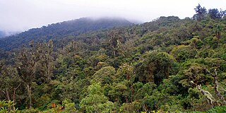
The Cordillera Oriental or Eastern Cordillera is a set of parallel mountain ranges of the Bolivian Andes, emplaced on the eastern and north eastern margin of the Andes. Large parts of Cordillera Oriental are forested and humid areas rich in agricultural and livestock products. Geologically, the Cordillera Oriental is formed by the Central Andean fold and thrust belt.
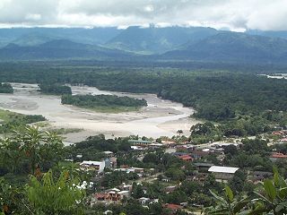
Villa Tunari or Tunari is a location in the department of Cochabamba, Bolivia. It is the seat of the Villa Tunari Municipality, the third municipal section of the Chapare Province. According to the census 2012 the population was 3,213 in the town which is an increment from 2,510 registered during the 2001 census.
Amboró National Park in central Bolivia is a nature reserve with over 912 species of birds, over 177 mammalian species including puma, ocelot, and the rare spectacled bear. Covering an area of 4,425 km², it is protected from human settlements, hunting, mining and deforestation, though problems with all these still exist within the park. The Carrasco National Park is placed adjacent to Amboró, and together the two form a larger conservation unit.

The Venezuelan Andes also simply known as the Andes in Venezuela, are a mountain system that form the northernmost extension of the Andes. They are fully identified, both by their geological origin as by the components of the relief, the constituent rocks and the geological structure.
Toledo (Oruro) is a small town in Bolivia. Toledo is the administrative seat of Saucarí Province, as well as that of Toledo Municipality. The town lies at an elevation of 3,715 metres (12,188 ft) between Río Laq'a Jawira in the west and Río Vinto Jahuira in the east, both of which drain into Lake Poopó.

The Andean orogeny is an ongoing process of orogeny that began in the Early Jurassic and is responsible for the rise of the Andes mountains. The orogeny is driven by a reactivation of a long-lived subduction system along the western margin of South America. On a continental scale the Cretaceous and Oligocene were periods of re-arrangements in the orogeny. The details of the orogeny vary depending on the segment and the geological period considered.

The geology of Bolivia comprises a variety of different lithologies as well as tectonic and sedimentary environments. On a synoptic scale, geological units coincide with topographical units. The country is divided into a mountainous western area affected by the subduction processes in the Pacific and an eastern lowlands of stable platforms and shields. The Bolivian Andes is divided into three main ranges; these are from west to east: the Cordillera Occidental that makes up the border to Chile and host several active volcanoes and geothermal areas, Cordillera Central once extensively mined for silver and tin and the relatively low Cordillera Oriental that rather than being a range by its own is the eastern continuation of the Central Cordillera as a fold and thrust belt. Between the Occidental and Central Cordillera the approximately 3,750-meter-high Altiplano high plateau extends. This basin hosts several freshwater lakes, including Lake Titicaca as well as salt-covered dry lakes that bring testimony of past climate changes and lake cycles. The eastern lowlands and sub-Andean zone in Santa Cruz, Chuquisaca, and Tarija Departments was once an old Paleozoic sedimentary basin that hosts valuable hydrocarbon reserves. Further east close to the border with Brazil lies the Guaporé Shield, made up of stable Precambrian crystalline rock.
The San Ramón is a Chilean geological fault, located in eastern Santiago Metropolitan Region, passing through the eastern part of Santiago marking the boundary between the Chilean Central Valley and the Andes. As an active thrust fault it constitutes a seismic hazard zone for the densely populated Santiago. A large number of homes and educational centers have been built on or near the fault, along with a gas plant in Peñalolén. The Chilean Nuclear Energy Commission has a reactor in La Reina, very close to the fault, which has raised concerns among the population. It runs 5 kilometers underground and extends for 25 kilometers in a north–south direction, lying between the Mapocho River and Maipo River. It is known to pass underneath the communes of Vitacura, Las Condes, La Reina, Peñalolén, La Florida and Puente Alto, and suspected to continue into Lo Barnechea and Pirque at its extremes. Due to its shallowness, it can cause very destructive superficial earthquakes with a magnitude around 7 on the Richter scale, with a general recurrence period of over 300 years.
Puma Apachita is a mountain in the Tunari mountain range of the Bolivian Andes, about 4,920 m (16,142 ft) high. It is situated in the Cochabamba Department, Quillacollo Province, Quillacollo Municipality, northwest of Cochabamba. Puma Apachita lies southeast of Jatun Q'asa.
The Andean foreland basins or Sub-Andean basins are a group of foreland basins located in the western half of South America immediately east of the Andes mountains. The Andean foreland basins in the Amazon River's catchment area are known as the Amazonian foreland basins.
Q'ara Apachita is a 4,046-metre-high (13,274 ft) mountain in the Bolivian Andes. It is located in the Cochabamba Department, Quillacollo Province, Sipe Sipe Municipality.

The Huincul Fault or Huincul Fault Zone is an east-to-west-oriented, continental-scale fault that extends from the Neuquén Basin eastwards into the Argentine Shelf. To the west, it has been proposed to extend across the Andes to the Chilean Coast Range.
Route 7 is a national road in the South American Andean state of Bolivia.

The Chile–Peru border is an international border of South America. It separates Chile from Peru along a line that runs about 10 km north of the Arica–La Paz railway. The border runs from the bend of coast known as the "Arica-Elbow" at the Pacific Ocean inland in northeast direction into the Andes and the Altiplano Plateau. The border was established in 1929 with the Treaty of Lima. Venezuelan migrants seeking to enter Chile avoid the Chile–Peru border as it better guarded than the Bolivia–Chile border.
References
- ↑ Dewey, J.F; Lamb, S.H (1992), "Active tectonics of the Andes", Tectonophysics , 205 (1–3): 79–95, doi:10.1016/0040-1951(92)90419-7
Major South American geological features | |||||
|---|---|---|---|---|---|
| Tectonic plates |  | ||||
| Cratons and shields | |||||
| Structures undergoing subduction | |||||
| Faults and shear zones | |||||
| Rifts and grabens | |||||
| Sedimentary basins | |||||
| Orogenies | |||||
| Metallogenetic provinces | |||||
| Volcanism |
| ||||
| | This tectonics article is a stub. You can help Wikipedia by expanding it. |
| | This Bolivia location article is a stub. You can help Wikipedia by expanding it. |