Shield (geology)

Last updated
Geologic provinces of the world (USGS)
.mw-parser-output .col-begin{border-collapse:collapse;padding:0;color:inherit;width:100%;border:0;margin:0}.mw-parser-output .col-begin-small{font-size:90%}.mw-parser-output .col-break{vertical-align:top;text-align:left}.mw-parser-output .col-break-2{width:50%}.mw-parser-output .col-break-3{width:33.3%}.mw-parser-output .col-break-4{width:25%}.mw-parser-output .col-break-5{width:20%}@media(max-width:720px){.mw-parser-output .col-begin,.mw-parser-output .col-begin>tbody,.mw-parser-output .col-begin>tbody>tr,.mw-parser-output .col-begin>tbody>tr>td{display:block!important;width:100%!important}.mw-parser-output .col-break{padding-left:0!important}}
.mw-parser-output .legend{page-break-inside:avoid;break-inside:avoid-column}.mw-parser-output .legend-color{display:inline-block;min-width:1.25em;height:1.25em;line-height:1.25;margin:1px 0;text-align:center;border:1px solid black;background-color:transparent;color:black}.mw-parser-output .legend-text{}
Shield
Platform
Orogen
Basin
Large igneous province
Extended crust
Oceanic crust:
0-20 Ma
20-65 Ma
>65 Ma World geologic provinces.jpg
Geologic provinces of the world (USGS)

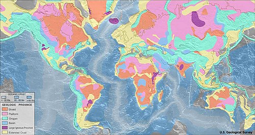
A shield is a large area of exposed Precambrian crystalline igneous and high-grade metamorphic rocks that form tectonically stable areas. [1] These rocks are older than 570 million years and sometimes date back to around 2 to 3.5 billion years.[ citation needed ] They have been little affected by tectonic events following the end of the Precambrian, and are relatively flat regions where mountain building, faulting, and other tectonic processes are minor, compared with the activity at their margins and between tectonic plates. Shields occur on all continents.

Contents

Terminology

The term shield cannot be used interchangeably with the term craton. However, shield can be used interchangeably with the term basement. The difference is that a craton describes a basement overlayed by a sedimentary platform while shield only describes the basement.

The term shield, used to describe this type of geographic region, appears in the 1901 English translation of Eduard Suess's Face of Earth by H. B. C. Sollas, and comes from the shape "not unlike a flat shield" [2] of the Canadian Shield which has an outline that "suggests the shape of the shields carried by soldiers in the days of hand-to-hand combat." [3]

Lithology

A shield is that part of the continental crust in which these usually Precambrian basement rocks crop out extensively at the surface. Shields can be very complex: they consist of vast areas of granitic or granodioritic gneisses, usually of tonalitic composition, and they also contain belts of sedimentary rocks, often surrounded by low-grade volcano-sedimentary sequences, or greenstone belts. These rocks are frequently metamorphosed greenschist, amphibolite, and granulite facies.[ citation needed ] It is estimated that over 50% of Earth's shields surface is made up of gneiss. [4]

Erosion and landforms

Being relatively stable regions, the relief of shields is rather old, with elements such as peneplains being shaped in Precambrian times. The oldest peneplain identifiable in a shield is called a "primary peneplain"; [5] in the case of the Fennoscandian Shield, this is the Sub-Cambrian peneplain. [6]

The landforms and shallow deposits of northern shields that have been subject to Quaternary glaciation and periglaciation are distinct from those found closer to the equator. [5] Shield relief, including peneplains, can be protected from erosion by various means. [5] [7] Shield surfaces exposed to sub-tropical and tropical climate for long enough time can end up being silicified, becoming hard and extremely difficult to erode. [7] Erosion of peneplains by glaciers in shield regions is limited. [7] [8] In the Fennoscandian Shield, average glacier erosion during the Quaternary has amounted to tens of meters, though this was not evenly distributed. [8] For glacier erosion to be effective in shields, a long "preparation period" of weathering under non-glacial conditions may be a requirement. [7]

In weathered and eroded shields, inselbergs are common sights. [9]

List of shields

See also

Notes

  1. Kearey, P. (2001). The new Penguin dictionary of geology (2nd ed.). London: Penguin. p. 243. ISBN   0-14-051494-5. OCLC   59494925.
  2. Suess, Eduard; Sollas, William Johnson; Sollas, Hertha B. C. (3 June 2018). The face of the earth (Das antlitz der erde). Oxford, Clarendon press via Internet Archive.
  3. Miall, Andrew D. "Geological Regions". thecanadianencyclopedia.ca.
  4. Austrheim, Håkon; Corfu, Fernando; Bryhni, Inge; Andersen, Torgeir B. (2003). "The Proterozoic Hustad igneous complex: a low strain enclave with a key to the history of the Western Gneiss Region of Norway" (PDF). Precambrian Research . 120 (1–2): 149–175. Bibcode:2003PreR..120..149A. doi:10.1016/S0301-9268(02)00167-5.
  5. 1 2 3 Fairbridge, Rhodes W.; Finkl Jr., Charles W. (1980). "Cratonic erosion unconformities and peneplains". The Journal of Geology . 88 (1): 69–86. Bibcode:1980JG.....88...69F. doi:10.1086/628474. S2CID   129231129.
  6. Lidmar-Bergström, Karna (1988). "Denudation surfaces of a shield area in south Sweden". Geografiska Annaler . 70 A (4): 337–350. doi:10.1080/04353676.1988.11880265.
  7. 1 2 3 4 Fairbridge, Rhodes W. (1988). "Cyclical patterns of exposure, weathering and burial of cratonic surfaces, with some examples from North America and Australia". Geografiska Annaler . 70 A (4): 277–283. doi:10.1080/04353676.1988.11880257.
  8. 1 2 Lidmar-Bergström, Karna (1997). "A long-term perspective on glacial erosion". Earth Surface Processes and Landforms . 22 (3): 297–306. Bibcode:1997ESPL...22..297L. doi:10.1002/(SICI)1096-9837(199703)22:3<297::AID-ESP758>3.0.CO;2-R.
  9. Nenonen, Keijo; Johansson, Peter; Sallasmaa, Olli; Sarala, Pertti; Palmu, Jukka-Pekka (2018). "The inselberg landscape in Finnish Lapland: a morphological study based on the LiDAR data interpretation". Bulletin of the Geological Society of Finland . 90 (2): 239–256. doi: 10.17741/bgsf/90.2.008 .
  10. Merriam, D. F. (2005). Encyclopedia of Geology. Selley, Richard C., 1939-, Cocks, L. R. M. (Leonard Robert Morrison), 1938-, Plimer, I. R. Amsterdam: Elsevier Academic. p. 21. ISBN   9781601193674. OCLC   183883048.

Related Research Articles

<span class="mw-page-title-main">Peneplain</span> Low-relief plain formed by protracted erosion

In geomorphology and geology, a peneplain is a low-relief plain formed by protracted erosion. This is the definition in the broadest of terms, albeit with frequency the usage of peneplain is meant to imply the representation of a near-final stage of fluvial erosion during times of extended tectonic stability. Peneplains are sometimes associated with the cycle of erosion theory of William Morris Davis, but Davis and other workers have also used the term in a purely descriptive manner without any theory or particular genesis attached.

<span class="mw-page-title-main">Inselberg</span> Isolated, steep rock hill on relatively flat terrain

An inselberg or monadnock is an isolated rock hill, knob, ridge, or small mountain that rises abruptly from a gently sloping or virtually level surrounding plain. In Southern Africa a similar formation of granite is known as a koppie, an Afrikaans word from the Dutch diminutive word kopje. If the inselberg is dome-shaped and formed from granite or gneiss, it can also be called a bornhardt, though not all bornhardts are inselbergs. An inselberg results when a body of rock resistant to erosion, such as granite, occurring within a body of softer rocks, is exposed by differential erosion and lowering of the surrounding landscape.

<span class="mw-page-title-main">Baltic Shield</span> Ancient segment of Earths crust

The Baltic Shield is a segment of the Earth's crust belonging to the East European Craton, representing a large part of Fennoscandia, northwestern Russia and the northern Baltic Sea. It is composed mostly of Archean and Proterozoic gneisses and greenstone which have undergone numerous deformations through tectonic activity. It contains the oldest rocks of the European continent with a thickness of 250–300 km.

<span class="mw-page-title-main">Base level</span> Lowest limit for erosion processes

In geology and geomorphology a base level is the lower limit for an erosion process. The modern term was introduced by John Wesley Powell in 1875. The term was subsequently appropriated by William Morris Davis who used it in his cycle of erosion theory. The "ultimate base level" is the surface that results from projection of the sea level under landmasses. It is to this base level that topography tends to approach due to erosion, eventually forming a peneplain close to the end of a cycle of erosion.

<span class="mw-page-title-main">Craton</span> Old and stable part of the continental lithosphere

A craton is an old and stable part of the continental lithosphere, which consists of Earth's two topmost layers, the crust and the uppermost mantle. Having often survived cycles of merging and rifting of continents, cratons are generally found in the interiors of tectonic plates; the exceptions occur where geologically recent rifting events have separated cratons and created passive margins along their edges. Cratons are characteristically composed of ancient crystalline basement rock, which may be covered by younger sedimentary rock. They have a thick crust and deep lithospheric roots that extend as much as several hundred kilometres into Earth's mantle.

<span class="mw-page-title-main">Greenstone belt</span> Zone of variably metamorphosed rocks occurring in Archaean and Proterozoic cratons

Greenstone belts are zones of variably metamorphosed mafic to ultramafic volcanic sequences with associated sedimentary rocks that occur within Archaean and Proterozoic cratons between granite and gneiss bodies.

<span class="mw-page-title-main">Glacial landform</span> Landform created by the action of glaciers

Glacial landforms are landforms created by the action of glaciers. Most of today's glacial landforms were created by the movement of large ice sheets during the Quaternary glaciations. Some areas, like Fennoscandia and the southern Andes, have extensive occurrences of glacial landforms; other areas, such as the Sahara, display rare and very old fossil glacial landforms.

Rhodes Whitmore Fairbridge was an Australian geologist and expert on climate change. His father was Kingsley Fairbridge.

<span class="mw-page-title-main">Geology of the Rocky Mountains</span> Discontinuous series of North American mountain ranges with distinct geological origin

The geology of the Rocky Mountains is that of a discontinuous series of mountain ranges with distinct geological origins. Collectively these make up the Rocky Mountains, a mountain system that stretches from Northern British Columbia through central New Mexico and which is part of the great mountain system known as the North American Cordillera.

<span class="mw-page-title-main">Laurentia</span> Craton forming the geological core of North America

Laurentia or the North American Craton is a large continental craton that forms the ancient geological core of North America. Many times in its past, Laurentia has been a separate continent, as it is now in the form of North America, although originally it also included the cratonic areas of Greenland and also the northwestern part of Scotland, known as the Hebridean Terrane. During other times in its past, Laurentia has been part of larger continents and supercontinents and consists of many smaller terranes assembled on a network of early Proterozoic orogenic belts. Small microcontinents and oceanic islands collided with and sutured onto the ever-growing Laurentia, and together formed the stable Precambrian craton seen today.

<span class="mw-page-title-main">Scandinavian Mountains</span> Mountain range in Finland, Norway and Sweden

The Scandinavian Mountains or the Scandes is a mountain range that runs through the Scandinavian Peninsula. The western sides of the mountains drop precipitously into the North Sea and Norwegian Sea, forming the fjords of Norway, whereas to the northeast they gradually curve towards Finland. To the north they form the border between Norway and Sweden, reaching 2,000 metres (6,600 ft) high at the Arctic Circle. The mountain range just touches northwesternmost Finland but are scarcely more than hills at their northernmost extension at the North Cape.

<span class="mw-page-title-main">Sub-Cambrian peneplain</span> Ancient, extremely flat, erosion surface

The sub-Cambrian peneplain is an ancient, extremely flat, erosion surface (peneplain) that has been exhumed and exposed by erosion from under Cambrian strata over large swathes of Fennoscandia. Eastward, where this peneplain dips below Cambrian and other Lower Paleozoic cover rocks. The exposed parts of this peneplain are extraordinarily flat with relief of less than 20 m. The overlying cover rocks demonstrate that the peneplain was flooded by shallow seas during the Early Paleozoic. Being the oldest identifiable peneplain in its area the Sub-Cambrian peneplain qualifies as a primary peneplain.

<span class="mw-page-title-main">South Swedish highlands</span> Hilly area covering large parts of Sweden

The South Swedish highlands or South Swedish Uplands are a hilly area covering large parts of Götaland in southern Sweden. Except for a lack of deep valleys, the landscape is similar to the Norrland terrain found further north in Sweden. The central-eastern parts of the highlands contain about thirty narrow canyons locally known as skurus.

<span class="mw-page-title-main">South Småland peneplain</span>

The South Småland peneplain is a large flattish erosion surface, a peneplain, formed during the Tertiary, covering large swathes of southern Småland and nearby areas in Southern Sweden. To the east the South Småland peneplain bounds with the Sub-Cambrian peneplain uphill across an escarpment. While is almost as flat as the Sub-Cambrian peneplain the South Småland peneplain differs in that it contains far more residual hills and that it has never been covered by sedimentary rocks. To the south and west the peneplain transitions into Mesozoic-aged hilly surfaces.

The geology of the Baltic Sea is characterized by having areas located both at the Baltic Shield of the East European Craton and in the Danish-North German-Polish Caledonides. Historical geologists make a distinction between the current Baltic Sea depression, formed in the Cenozoic era, and the much older sedimentary basins whose sediments are preserved in the zone. Although glacial erosion has contributed to shape the present depression, the Baltic trough is largely a depression of tectonic origin that existed long before the Quaternary glaciation.

In north European geology, Jotnian sediments are a group of Precambrian rocks more specifically assigned to the Mesoproterozoic Era (Riphean), albeit some might be younger. Jotnian sediments include the oldest known sediments in the Baltic area that have not been subject to metamorphism. Stratigraphically, Jotnian sediments overlie the rapakivi granites and other igneous and metamorphic rocks and are often intruded by younger diabases.

<span class="mw-page-title-main">Geology of Finland</span> Overview of the geology of Finland

The geology of Finland is made up of a mix of geologically very young and very old materials. Common rock types are orthogneiss, granite, metavolcanics and metasedimentary rocks. On top of these lies a widespread thin layer of unconsolidated deposits formed in connection to the Quaternary ice ages, for example eskers, till and marine clay. The topographic relief is rather subdued because mountain massifs were worn down to a peneplain long ago.

<span class="mw-page-title-main">Tectonic evolution of the Aravalli Mountains</span> Overview article

The Aravalli Mountain Range is a northeast-southwest trending orogenic belt in the northwest part of India and is part of the Indian Shield that was formed from a series of cratonic collisions. The Aravalli Mountains consist of the Aravalli and Delhi fold belts, and are collectively known as the Aravalli-Delhi orogenic belt. The whole mountain range is about 700 km long. Unlike the much younger Himalayan section nearby, the Aravalli Mountains are believed much older and can be traced back to the Proterozoic Eon. They are arguably the oldest geological feature on Earth. The collision between the Bundelkhand craton and the Marwar craton is believed to be the primary mechanism for the development of the mountain range.

<span class="mw-page-title-main">Sub-Mesozoic hilly peneplains</span> Landscape in Scandinavia of undulating hills and joint valleys

The Sub-Mesozoic hilly peneplains or Sub-Mesozoic hilly relief is a landscape in Scandinavia made up of undulating hills and joint valleys and occasional kaolinized bedrock in valley bottoms. The landscape formed in the Mesozoic Era and was eventually drowned by the sea during the Campanian transgression and covered by a thick cover of Cretaceous sedimentary rocks. Later erosion of the cover rocks partly re-exposed this landscape. During the Quaternary epoch the re-exposed Mesozoic hilly relief escaped major glacier erosion being only surficially scoured in parts.

The geology of Bhutan is less well studied than many countries in Asia, together with the broader Eastern Himalayas region. Older Paleozoic and Precambrian rocks often appear mixed together with younger sediments due to the Himalayan orogeny.