Orogenic belt

Last updated
Geologic provinces of the world (USGS)
.mw-parser-output .legend{page-break-inside:avoid;break-inside:avoid-column}.mw-parser-output .legend-color{display:inline-block;min-width:1.25em;height:1.25em;line-height:1.25;margin:1px 0;text-align:center;border:1px solid black;background-color:transparent;color:black}.mw-parser-output .legend-text{}
Shield
Platform
Orogen
Basin
Large igneous province
Extended crust
Oceanic crust:
0-20 Ma
20-65 Ma
>65 Ma World geologic provinces.jpg
Geologic provinces of the world (USGS)

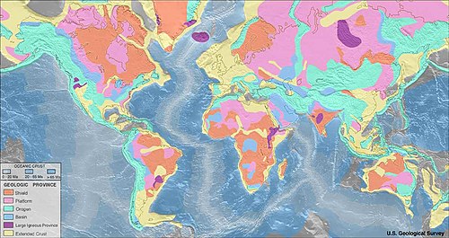
An orogenic belt, orogen, or mobile belt, [lower-alpha 1] is a zone of Earth's crust affected by orogeny. [2] An orogenic belt develops when a continental plate crumples and is uplifted to form one or more mountain ranges; this involves a series of geological processes collectively called orogenesis. [3] [4]

Contents

Overview

Orogeny typically produces orogenic belts, which are elongated regions of deformation bordering continental cratons. Young orogenic belts, in which subduction is still taking place, are characterized by frequent volcanic activity and earthquakes. Older orogenic belts are typically deeply eroded to expose displaced and deformed strata. These are often highly metamorphosed and include vast bodies of intrusive igneous rock called batholiths. [5]

Orogenic belts are associated with subduction zones, which consume crust, thicken lithosphere, produce earthquake and volcanoes, and often build island arcs. These island arcs may be added to a continental margin during an accretionary orogeny. The orogeny may culminate with continental crust from the opposite side of the subducting oceanic plate arriving at the subduction zone. This ends subduction and transforms the accretional orogeny into a collisional orogeny. The collisional orogeny may produce extremely high mountains, as has been taking place in the Himalayas for the last 65 million years. [5] [ clarification needed ]

Prominently orogenic belts on the Earth are the circum-Pacific orogenic belt (Pacific Ring of Fire) and Alpine-Himalayan orogenic belt. [5] Since these orogenic belts are young orogenic belts, they form large mountain ranges, crustal activity is active, and accompanied by volcanic belts and seismic belts. [6]

Notes

  1. The term mobile belt is sometimes preferred for orogenic belts to which plate-tectonic models cannot be applied as easily due to their age. [1]

Related Research Articles

<span class="mw-page-title-main">Orogeny</span> The formation of mountain ranges

Orogeny is a mountain-building process that takes place at a convergent plate margin when plate motion compresses the margin. An orogenic belt or orogen develops as the compressed plate crumples and is uplifted to form one or more mountain ranges. This involves a series of geological processes collectively called orogenesis. These include both structural deformation of existing continental crust and the creation of new continental crust through volcanism. Magma rising in the orogen carries less dense material upwards while leaving more dense material behind, resulting in compositional differentiation of Earth's lithosphere. A synorogenic process or event is one that occurs during an orogeny.

<span class="mw-page-title-main">Subduction</span> A geological process at convergent tectonic plate boundaries where one plate moves under the other

Subduction is a geological process in which the oceanic lithosphere and some continental lithosphere is recycled into the Earth's mantle at convergent boundaries. Where the oceanic lithosphere of a tectonic plate converges with the less dense lithosphere of a second plate, the heavier plate dives beneath the second plate and sinks into the mantle. A region where this process occurs is known as a subduction zone, and its surface expression is known as an arc-trench complex. The process of subduction has created most of the Earth's continental crust. Rates of subduction are typically measured in centimeters per year, with rates of convergence as high as 11 cm/year.

Obduction is a geological process whereby denser oceanic crust is scraped off a descending ocean plate at a convergent plate boundary and thrust on top of an adjacent plate. When oceanic and continental plates converge, normally the denser oceanic crust sinks under the continental crust in the process of subduction. Obduction, which is less common, normally occurs in plate collisions at orogenic belts or back-arc basins.

<span class="mw-page-title-main">Convergent boundary</span> Region of active deformation between colliding tectonic plates

A convergent boundary is an area on Earth where two or more lithospheric plates collide. One plate eventually slides beneath the other, a process known as subduction. The subduction zone can be defined by a plane where many earthquakes occur, called the Wadati–Benioff zone. These collisions happen on scales of millions to tens of millions of years and can lead to volcanism, earthquakes, orogenesis, destruction of lithosphere, and deformation. Convergent boundaries occur between oceanic-oceanic lithosphere, oceanic-continental lithosphere, and continental-continental lithosphere. The geologic features related to convergent boundaries vary depending on crust types.

<span class="mw-page-title-main">Antler orogeny</span> Tectonic event from the Late Devonian into the Mississippian and early Pennsylvanian

The Antler orogeny was a tectonic event that began in the early Late Devonian with widespread effects continuing into the Mississippian and early Pennsylvanian. Most of the evidence for this event is in Nevada but the limits of its reach are unknown. A great volume of conglomeratic deposits of mainly Mississippian age in Nevada and adjacent areas testifies to the existence of an important tectonic event, and implies nearby areas of uplift and erosion, but the nature and cause of that event are uncertain and in dispute. Although it is known as an orogeny, some of the classic features of orogeny as commonly defined such as metamorphism, and granitic intrusives have not been linked to it. In spite of this, the event is universally designated as an orogeny and that practice is continued here. This article outlines what is known and unknown about the Antler orogeny and describes three current theories regarding its nature and origin.

<span class="mw-page-title-main">Geology of the Himalayas</span> Origins and structure of the mountain range

The geology of the Himalayas is a record of the most dramatic and visible creations of the immense mountain range formed by plate tectonic forces and sculpted by weathering and erosion. The Himalayas, which stretch over 2400 km between the Namcha Barwa syntaxis at the eastern end of the mountain range and the Nanga Parbat syntaxis at the western end, are the result of an ongoing orogeny — the collision of the continental crust of two tectonic plates, namely, the Indian Plate thrusting into the Eurasian Plate. The Himalaya-Tibet region supplies fresh water for more than one-fifth of the world population, and accounts for a quarter of the global sedimentary budget. Topographically, the belt has many superlatives: the highest rate of uplift, the highest relief, among the highest erosion rates at 2–12 mm/yr, the source of some of the greatest rivers and the highest concentration of glaciers outside of the polar regions. This last feature earned the Himalaya its name, originating from the Sanskrit for "the abode of the snow".

<span class="mw-page-title-main">Geology of Japan</span> Overview of the geology of Japan

The islands of Japan are primarily the result of several large ocean movements occurring over hundreds of millions of years from the mid-Silurian to the Pleistocene, as a result of the subduction of the Philippine Sea Plate beneath the continental Amurian Plate and Okinawa Plate to the south, and subduction of the Pacific Plate under the Okhotsk Plate to the north.

<span class="mw-page-title-main">Continental collision</span> Phenomenon in which mountains can be produced on the boundaries of converging tectonic plates

In geology, continental collision is a phenomenon of plate tectonics that occurs at convergent boundaries. Continental collision is a variation on the fundamental process of subduction, whereby the subduction zone is destroyed, mountains produced, and two continents sutured together. Continental collision is only known to occur on Earth.

The Nevadan orogeny occurred along the western margin of North America during the Middle Jurassic to Early Cretaceous time which is approximately from 155 Ma to 145 Ma. Throughout the duration of this orogeny there were at least two different kinds of orogenic processes occurring. During the early stages of orogenesis an "Andean type" continental magmatic arc developed due to subduction of the Farallon oceanic plate beneath the North American Plate. The latter stages of orogenesis, in contrast, saw multiple oceanic arc terranes accreted onto the western margin of North America in a "Cordilleran type" accretionary orogen. Deformation related to the accretion of these volcanic arc terranes is mostly limited to the western regions of the resulting mountain ranges and is absent from the eastern regions. In addition, the deformation experienced in these mountain ranges is mostly due to the Nevadan orogeny and not other external events such as the more recent Sevier and Laramide Orogenies. It is noted that the Klamath Mountains and the Sierra Nevada share similar stratigraphy indicating that they were both formed by the Nevadan orogeny. In comparison with other orogenic events, it appears that the Nevadan Orogeny occurred rather quickly taking only about 10 million years as compared to hundreds of millions of years for other orogenies around the world.

<span class="mw-page-title-main">Grenville orogeny</span> Mesoproterozoic mountain-building event

The Grenville orogeny was a long-lived Mesoproterozoic mountain-building event associated with the assembly of the supercontinent Rodinia. Its record is a prominent orogenic belt which spans a significant portion of the North American continent, from Labrador to Mexico, as well as to Scotland.

<span class="mw-page-title-main">Alpide belt</span> Belt of Eurasian mountain ranges

The Alpide belt or Alpine-Himalayan orogenic belt, or more recently and rarely the Tethyan orogenic belt, is a seismic and orogenic belt that includes an array of mountain ranges extending for more than 15,000 kilometres (9,300 mi) along the southern margin of Eurasia, stretching from Java and Sumatra, through the Indochinese Peninsula, the Himalayas and Transhimalayas, the mountains of Iran, Caucasus, Anatolia, the Mediterranean, and out into the Atlantic.

<span class="mw-page-title-main">Accretionary wedge</span> The sediments accreted onto the non-subducting tectonic plate at a convergent plate boundary

An accretionary wedge or accretionary prism forms from sediments accreted onto the non-subducting tectonic plate at a convergent plate boundary. Most of the material in the accretionary wedge consists of marine sediments scraped off from the downgoing slab of oceanic crust, but in some cases the wedge includes the erosional products of volcanic island arcs formed on the overriding plate.

<span class="mw-page-title-main">Trans-Hudson orogeny</span> Mountain-building event in North America

The Trans-Hudson orogeny or Trans-Hudsonian orogeny was the major mountain building event (orogeny) that formed the Precambrian Canadian Shield and the North American Craton, forging the initial North American continent. It gave rise to the Trans-Hudson orogen (THO), or Trans-Hudson Orogen Transect (THOT), which is the largest Paleoproterozoic orogenic belt in the world. It consists of a network of belts that were formed by Proterozoic crustal accretion and the collision of pre-existing Archean continents. The event occurred 2.0–1.8 billion years ago.

<span class="mw-page-title-main">Philippine Mobile Belt</span> Tectonic boundary

In the geology of the Philippines, the Philippine Mobile Belt is a complex portion of the tectonic boundary between the Eurasian Plate and the Philippine Sea Plate, comprising most of the country of the Philippines. It includes two subduction zones, the Manila Trench to the west and the Philippine Trench to the east, as well as the Philippine Fault System. Within the Belt, a number of crustal blocks or microplates which have been shorn off the adjoining major plates are undergoing massive deformation.

In geology, the term exhumation refers to the process by which a parcel of rock, approaches Earth's surface.

<span class="mw-page-title-main">Sveconorwegian orogeny</span> Orogenic belt in southwestern Sweden and southern Norway

The Sveconorwegian orogeny was an orogenic system active 1140 to 960 million years ago and currently exposed as the Sveconorwegian orogenic belt in southwestern Sweden and southern Norway. In Norway the orogenic belt is exposed southeast of the front of the Caledonian nappe system and in nappe windows. The Sveconorwegian orogen is commonly grouped within the Grenvillian Mesoproterozoic orogens. Contrary to many other known orogenic belts the Sveconorwegian orogens eastern border does not have any known suture zone with ophiolites.

<span class="mw-page-title-main">Svecofennian orogeny</span> Geological process that resulted in formation of continental crust in Sweden, Finland and Russia

The Svecofennian orogeny is a series of related orogenies that resulted in the formation of much of the continental crust in what is today Sweden and Finland plus some minor parts of Russia. The orogenies lasted from about 2000 to 1800 million years ago during the Paleoproterozoic Era. The resulting orogen is known as the Svecofennian orogen or Svecofennides. To the west and southwest the Svecofennian orogen limits with the generally younger Transscandinavian Igneous Belt. It is assumed that the westernmost fringes of the Svecofennian orogen have been reworked by the Sveconorwegian orogeny just as the western parts of the Transscandinavian Igneous Belt has. The Svecofennian orogeny involved the accretion of numerous island arcs in such manner that the pre-existing craton grew with this new material from what is today northeast to the southwest. The accretion of the island arcs was also related to two other processes that occurred in the same period; the formation of magma that then cooled to form igneous rocks and the metamorphism of rocks.

<span class="mw-page-title-main">Tectonic evolution of the Aravalli Mountains</span> Overview article

The Aravalli Mountain Range is a northeast-southwest trending orogenic belt in the northwest part of India and is part of the Indian Shield that was formed from a series of cratonic collisions. The Aravalli Mountains consist of the Aravalli and Delhi fold belts, and are collectively known as the Aravalli-Delhi orogenic belt. The whole mountain range is about 700 km long. Unlike the much younger Himalayan section nearby, the Aravalli Mountains are believed much older and can be traced back to the Proterozoic Eon. They are arguably the oldest geological feature on Earth. The collision between the Bundelkhand craton and the Marwar craton is believed to be the primary mechanism for the development of the mountain range.

The Hellenic orogeny is a collective noun referring to multiple mountain building events that shaped the topography of the southern margin of Eurasia into what is now Greece, the Aegean Sea and western Turkey, beginning in the Jurassic. Prior to then the supercontinent, Pangaea, had divided along a divergent boundary into two continents, Gondwana land and Laurasia, separated by a primordial ocean, Paleo-Tethys Ocean. As the two continents continued to break up, Gondwana, pushed by divergent boundaries developing elsewhere, began to drift to the north, closing the sea. As it went it split off a number of smaller land masses, terranes, which preceded it to the north. The Hellenic orogeny is the story of the collision first of these terranes and then of Gondwana, reduced to Africa, with Eurasia, and the closing of Tethys to the Mediterranean. The process has been ongoing since the Jurassic and continues today.

<span class="mw-page-title-main">Central Asian Orogenic Belt</span> Phanerozoic accretionary orogen

The Central Asian Orogenic Belt (CAOB), also called the Altaids, is one of the world's largest Phanerozoic accretionary orogens, and thus a leading laboratory of geologically recent crustal growth. The orogenic belt is bounded by the East European Craton and the North China Craton in the Northwest-Southeast direction, as well as Siberia Craton and Tarim Craton in the Northeast-Southwest direction. It formed by ocean closures during Neoproterozoic to the late Phanerozoic time, from around 750 to 150 Ma. Like many other accretionary orogenic belts, the Central Asian Orogenic Belt consists of a huge amount of magmatic arcs, arc-related basins, accretionary complexes, seamounts, continental fragments and ophiolites. It is also considered a relatively distinctive collisional orogenic belt because widespread subduction-accretion complexes and arc magmatic rocks can be found in the region, but collision-related foreland basins are not common.

References

  1. "mobile belt". www.encyclopedia.com. Oxford University Press. Retrieved 2022-12-26.
  2. "Orogenic belt | geology". Encyclopedia Britannica. Retrieved 2021-04-29.
  3. Tony Waltham (2009). Foundations of Engineering Geology (3rd ed.). Taylor & Francis. p. 20. ISBN   978-0-415-46959-3.
  4. Philip Kearey; Keith A. Klepeis; Frederick J. Vine (2009). "Chapter 10: Orogenic belts". Global Tectonics (3rd ed.). Wiley-Blackwell. p. 287. ISBN   978-1-4051-0777-8.
  5. 1 2 3 "Orogenic Belt - an overview | ScienceDirect Topics". www.sciencedirect.com. Retrieved 2021-04-29.
  6. "Ring of Fire | Definition, Map, & Facts". Encyclopedia Britannica. Retrieved 2021-04-29.

Commons-logo.svg Media related to Orogenic belts at Wikimedia Commons