
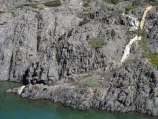
A thrust fault is a break in the Earth's crust, across which older rocks are pushed above younger rocks.

In geology, a fault is a planar fracture or discontinuity in a volume of rock across which there has been significant displacement as a result of rock-mass movements. Large faults within Earth's crust result from the action of plate tectonic forces, with the largest forming the boundaries between the plates, such as subduction zones or transform faults. Energy release associated with rapid movement on active faults is the cause of most earthquakes. Faults may also displace slowly, by aseismic creep.

Tectonics are the processes that control the structure and properties of the Earth's crust and its evolution through time. These include the processes of mountain building, the growth and behavior of the strong, old cores of continents known as cratons, and the ways in which the relatively rigid plates that constitute the Earth's outer shell interact with each other. Tectonics also provide a framework for understanding the earthquake and volcanic belts that directly affect much of the global population.

In structural geology, a fold is a stack of originally planar surfaces, such as sedimentary strata, that are bent or curved during permanent deformation. Folds in rocks vary in size from microscopic crinkles to mountain-sized folds. They occur as single isolated folds or in periodic sets. Synsedimentary folds are those formed during sedimentary deposition.

The Moine Thrust Belt or Moine Thrust Zone is a linear tectonic feature in the Scottish Highlands which runs from Loch Eriboll on the north coast 190 kilometres (120 mi) south-west to the Sleat peninsula on the Isle of Skye. The thrust belt consists of a series of thrust faults that branch off the Moine Thrust itself. Topographically, the belt marks a change from rugged, terraced mountains with steep sides sculptured from weathered igneous, sedimentary and metamorphic rocks in the west to an extensive landscape of rolling hills over a metamorphic rock base to the east. Mountains within the belt display complexly folded and faulted layers and the width of the main part of the zone varies up to 10 kilometres (6.2 mi), although it is significantly wider on Skye.
In geology, a shear zone is a thin zone within the Earth's crust or upper mantle that has been strongly deformed, due to the walls of rock on either side of the zone slipping past each other. In the upper crust, where rock is brittle, the shear zone takes the form of a fracture called a fault. In the lower crust and mantle, the extreme conditions of pressure and temperature make the rock ductile. That is, the rock is capable of slowly deforming without fracture, like hot metal being worked by a blacksmith. Here the shear zone is a wider zone, in which the ductile rock has slowly flowed to accommodate the relative motion of the rock walls on either side.
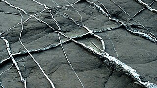
In geology, a vein is a distinct sheetlike body of crystallized minerals within a rock. Veins form when mineral constituents carried by an aqueous solution within the rock mass are deposited through precipitation. The hydraulic flow involved is usually due to hydrothermal circulation.

In geology, shear is the response of a rock to deformation usually by compressive stress and forms particular textures. Shear can be homogeneous or non-homogeneous, and may be pure shear or simple shear. Study of geological shear is related to the study of structural geology, rock microstructure or rock texture and fault mechanics.
The Lewis Overthrust is a geologic thrust fault structure of the Rocky Mountains found within the bordering national parks of Glacier in Montana, United States and Waterton Lakes in Alberta, Canada. The structure was created due to the collision of tectonic plates about 170 million years ago that drove a several mile thick wedge of rock 50 mi (80 km) eastwards, causing it to overlie softer Cretaceous age rock that is 400 to 500 million years younger.
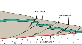
Thrust tectonics or contractional tectonics is concerned with the structures formed by, and the tectonic processes associated with, the shortening and thickening of the crust or lithosphere. It is one of the three main types of tectonic regime, the others being extensional tectonics and strike-slip tectonics. These match the three types of plate boundary, convergent (thrust), divergent (extensional) and transform (strike-slip). There are two main types of thrust tectonics, thin-skinned and thick-skinned, depending on whether or not basement rocks are involved in the deformation. The principle geological environments where thrust tectonics is observed are zones of continental collision, restraining bends on strike-slip faults and as part of detached fault systems on some passive margins.
Strike-slip tectonics is concerned with the structures formed by, and the tectonic processes associated with, zones of lateral displacement within the Earth's crust or lithosphere. It is one of the three main types of tectonic regime, the others being extensional tectonics and thrust tectonics. These match the three types of plate boundary: transform (strike-slip), divergent (extensional) and convergent (thrust). Areas of strike-slip tectonics are associated with particular deformation styles including Riedel shears, flower structures and strike-slip duplexes. This type of tectonics is characteristic of several geological environments, including oceanic and continental transform faults, zones of oblique collision and the deforming foreland of a zone of continental collision.

A fault trace describes the intersection of a geological fault with the Earth's surface, which leaves a visible disturbance on the surface, usually looking like a crack in the surface with jagged rock structures protruding outward. The term also applies to a line plotted on a geological map to represent a fault. These fractures tend to occur when a slip surface expands from a fault core, especially during an earthquake. This tends to occur with fault displacement, in which surfaces on both sides of a fault, known as fault blocks, separate horizontally or vertically.

In structural geology inversion or basin inversion relates to the relative uplift of a sedimentary basin or similar structure as a result of crustal shortening. This normally excludes uplift developed in the footwalls of later extensional faults, or uplift caused by mantle plumes. "Inversion" can also refer to individual faults, where an extensional fault is reactivated in the opposite direction to its original movement.

In structural geology section restoration or palinspastic restoration is a technique used to progressively undeform a geological section in an attempt to validate the interpretation used to build the section. It is also used to provide insights into the geometry of earlier stages of the geological development of an area. A section that can be successfully undeformed to a geologically reasonable geometry, without change in area, is known as a balanced section.
On October 31 at 17:53 UTC the island of New Guinea was shaken by an earthquake of magnitude 6.9 that particularly affected the city of Madang on the north coast of Papua New Guinea. Causing between five and eighteen fatalities, it triggered landslides that ran down steep hills into poorly reinforced wooden huts. The area that experienced the most powerful intensity extended 20 kilometers (12 mi) out from the epicenter. Underwater landslides caused minor tsunami over about 100 km of coast and severed underwater cables in several places.

The Atacama Fault Zone (AFZ) is an extensive system of faults cutting across the Chilean Coastal Cordillera in Northern Chile between the Andean Mountain range and the Pacific Ocean. The fault system is North-South striking and runs for more than 1100 km North and up to 50 km in width through the Andean forearc region. The zone is a direct result of the ongoing subduction of the Eastward moving Nazca Plate beneath the South American Plate and is believed to have formed in the Early Jurassic during the beginnings of the Andean orogeny. The zone can be split into 3 regions: the North, Central and South.
Strain partitioning is commonly referred to as a deformation process in which the total strain experienced on a rock, area, or region, is heterogeneously distributed in terms of the strain intensity and strain type. This process is observed on a range of scales spanning from the grain – crystal scale to the plate – lithospheric scale, and occurs in both the brittle and plastic deformation regimes. The manner and intensity by which strain is distributed are controlled by a number of factors listed below.
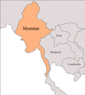
The geology of Myanmar is shaped by dramatic, ongoing tectonic processes controlled by shifting tectonic components as the Indian plate slides northwards and towards Southeast Asia. Myanmar spans across parts of three tectonic plates separated by north-trending faults. To the west, a highly oblique subduction zone separates the offshore Indian plate from the Burma microplate, which underlies most of the country. In the center-east of Myanmar, a right lateral strike slip fault extends from south to north across more than 1,000 km (620 mi). These tectonic zones are responsible for large earthquakes in the region. The India-Eurasia plate collision which initiated in the Eocene provides the last geological pieces of Myanmar, and thus Myanmar preserves a more extensive Cenozoic geological record as compared to records of the Mesozoic and Paleozoic eras. Myanmar is physiographically divided into three regions: the Indo-Burman Range, Myanmar Central Belt and the Shan Plateau; these all display an arcuate shape bulging westwards. The varying regional tectonic settings of Myanmar not only give rise to disparate regional features, but they also foster the formation of petroleum basins and a diverse mix of mineral resources.
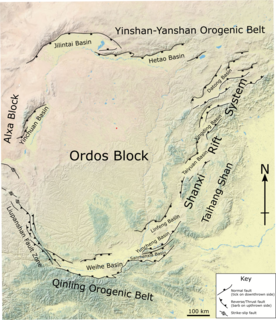
The Ordos Block is a crustal block, that forms part of the larger North China Block (NCB). It is surrounded by active fault systems and has been a distinct block since at least the Mesozoic. It is bordered to the west by the Alxa Block, the westernmost part of the NCB, to the south by the Qinling orogenic belt, to the north by the Yanshan-Yinshan orogenic belt, part of the Central Asian Orogenic Belt and to the east by the Taihangshan mountain range, which forms part of the Trans-North China Orogen. The block is currently stable and large earthquakes are restricted to the bordering fault zones. It has been suggested that the block is currently undergoing anti-clockwise rotation with respect to the Eurasian Plate, as a result of the ongoing eastward spreading of the Tibetan Plateau, although this view has been challenged.
The 1955 Zheduotang earthquake, also known as the Kangding earthquake occurred on April 14 at 09:29:02 local time near the city of Kangding in the Garzê Tibetan Autonomous Prefecture, Sichuan. The earthquake had a moment magnitude of 7.0 and a surface wave magnitude of 7.1 and struck at a depth of 10 km. Severe damage occurred in Kangding with the loss of 70 lives.

