
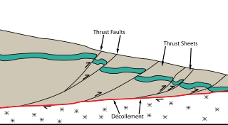
A thrust fault is a break in the Earth's crust, across which older rocks are pushed above younger rocks.

In structural geology, a fold is a stack of originally planar surfaces, such as sedimentary strata, that are bent or curved during permanent deformation. Folds in rocks vary in size from microscopic crinkles to mountain-sized folds. They occur as single isolated folds or in periodic sets. Synsedimentary folds are those formed during sedimentary deposition.

In geology, a nappe or thrust sheet is a large sheetlike body of rock that has been moved more than 2 km (1.2 mi) or 5 km (3.1 mi) above a thrust fault from its original position. Nappes form in compressional tectonic settings like continental collision zones or on the overriding plate in active subduction zones. Nappes form when a mass of rock is forced over another rock mass, typically on a low angle fault plane. The resulting structure may include large-scale recumbent folds, shearing along the fault plane, imbricate thrust stacks, fensters and klippes.

The Sevier orogeny was a mountain-building event that affected western North America from northern Canada to the north to Mexico to the south.
The Lewis Overthrust is a geologic thrust fault structure of the Rocky Mountains found within the bordering national parks of Glacier in Montana, United States and Waterton Lakes in Alberta, Canada. The structure was created due to the collision of tectonic plates about 170 million years ago that drove a several mile thick wedge of rock 50 mi (80 km) eastwards, causing it to overlie softer Cretaceous age rock that is 400 to 500 million years younger.

A foreland basin is a structural basin that develops adjacent and parallel to a mountain belt. Foreland basins form because the immense mass created by crustal thickening associated with the evolution of a mountain belt causes the lithosphere to bend, by a process known as lithospheric flexure. The width and depth of the foreland basin is determined by the flexural rigidity of the underlying lithosphere, and the characteristics of the mountain belt. The foreland basin receives sediment that is eroded off the adjacent mountain belt, filling with thick sedimentary successions that thin away from the mountain belt. Foreland basins represent an endmember basin type, the other being rift basins. Space for sediments is provided by loading and downflexure to form foreland basins, in contrast to rift basins, where accommodation space is generated by lithospheric extension.

Décollement is a gliding plane between two rock masses, also known as a basal detachment fault. Décollements are a deformational structure, resulting in independent styles of deformation in the rocks above and below the fault. They are associated with both compressional settings and extensional settings.
Thrust tectonics or contractional tectonics is concerned with the structures formed by, and the tectonic processes associated with, the shortening and thickening of the crust or lithosphere. It is one of the three main types of tectonic regime, the others being extensional tectonics and strike-slip tectonics. These match the three types of plate boundary, convergent (thrust), divergent (extensional) and transform (strike-slip). There are two main types of thrust tectonics, thin-skinned and thick-skinned, depending on whether or not basement rocks are involved in the deformation. The principle geological environments where thrust tectonics is observed are zones of continental collision, restraining bends on strike-slip faults and as part of detached fault systems on some passive margins.

Salt tectonics, or halokinesis, or halotectonics, is concerned with the geometries and processes associated with the presence of significant thicknesses of evaporites containing rock salt within a stratigraphic sequence of rocks. This is due both to the low density of salt, which does not increase with burial, and its low strength.

An accretionary wedge or accretionary prism forms from sediments accreted onto the non-subducting tectonic plate at a convergent plate boundary. Most of the material in the accretionary wedge consists of marine sediments scraped off from the downgoing slab of oceanic crust, but in some cases the wedge includes the erosional products of volcanic island arcs formed on the overriding plate.

The Rhenohercynian Zone or Rheno-Hercynian zone in structural geology describes a fold belt of west and central Europe, formed during the Hercynian orogeny. The zone consists of folded and thrusted Devonian and early Carboniferous sedimentary rocks that were deposited in a back-arc basin along the southern margin of the then existing paleocontinent Laurussia.

The Western Carpathians are an arc-shaped mountain range, the northern branch of the Alpine-Himalayan fold and thrust system called the Alpide belt, which evolved during the Alpine orogeny. In particular, their pre-Cenozoic evolution is very similar to that of the Eastern Alps, and they constitute a transition between the Eastern Alps and the Eastern Carpathians.

The Pyrenees are a 430-kilometre-long, roughly east–west striking, intracontinental mountain chain that divide France, Spain, and Andorra. The belt has an extended, polycyclic geological evolution dating back to the Precambrian. The chain's present configuration is due to the collision between the microcontinent Iberia and the southwestern promontory of the European Plate. The two continents were approaching each other since the onset of the Upper Cretaceous (Albian/Cenomanian) about 100 million years ago and were consequently colliding during the Paleogene (Eocene/Oligocene) 55 to 25 million years ago. After its uplift, the chain experienced intense erosion and isostatic readjustments. A cross-section through the chain shows an asymmetric flower-like structure with steeper dips on the French side. The Pyrenees are not solely the result of compressional forces, but also show an important sinistral shearing.

A detachment fold, in geology, occurs as layer parallel thrusting along a decollement develops without upward propagation of a fault; the accommodation of the strain produced by continued displacement along the underlying thrust results in the folding of the overlying rock units. As a visual aid, picture a rug on the floor. By placing your left foot on one end and pushing towards the other end of the rug, the rug slides across the floor (decollement) and folds upward. Figure 1, is a generalized representation of the geometry assumed by a detachment fault.
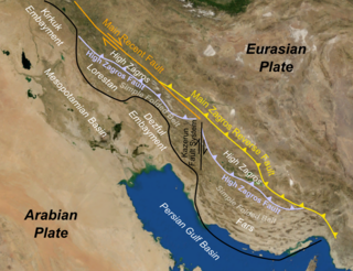
The Zagros fold and thrust belt is an approximately 1,800-kilometre (1,100 mi) long zone of deformed crustal rocks, formed in the foreland of the collision between the Arabian Plate and the Eurasian Plate. It is host to one of the world's largest petroleum provinces, containing about 49% of the established hydrocarbon reserves in fold and thrust belts (FTBs) and about 7% of all reserves globally.
Tectonic subsidence is the sinking of the Earth's crust on a large scale, relative to crustal-scale features or the geoid. The movement of crustal plates and accommodation spaces created by faulting create subsidence on a large scale in a variety of environments, including passive margins, aulacogens, fore-arc basins, foreland basins, intercontinental basins and pull-apart basins. Three mechanisms are common in the tectonic environments in which subsidence occurs: extension, cooling and loading.
Thick-skinned deformation is a geological term which refers to crustal shortening that involves basement rocks and deep-seated faults as opposed to only the upper units of cover rocks above the basement which is known as thin-skinned deformation. While thin-skinned deformation is common in many different localities, thick-skinned deformation requires much more strain to occur and is a rarer type of deformation.

In geology, 3D fold evolution is the study of the full three dimensional structure of a fold as it changes in time. A fold is a common three-dimensional geological structure that is associated with strain deformation under stress. Fold evolution in three dimensions can be broadly divided into two stages, namely fold growth and fold linkage. The evolution depends on fold kinematics, causes of folding, as well as alignment and interaction of the each structure with respect to each other. There are several ways to reconstruct the evolution progress of folds, notably by using depositional evidence, geomorphological evidence and balanced restoration. Understanding the evolution of folds is important because it helps petroleum geologists to gain a better understanding on the distribution of structural traps of hydrocarbon.
The geology of Iraq includes thick sequences of marine and continental sedimentary rocks over poorly understood basement rock, at the junction of the Arabian Plate, the Anatolian Plate, and the Iranian Plate.

Junggar Basin is one of the largest sedimentary basins in Northwest China. It is located in Xinjiang, and enclosed by the Tarbagatai Mountains of Kazakhstan in the northwest, the Altai Mountains of Mongolia in the northeast, and the Heavenly Mountains in the south. The geology of Junggar Basin mainly consists of sedimentary rocks underlain by igneous and metamorphic basement rocks. The basement of the basin was largely formed during the development of the Pangea supercontinent during complex tectonic events from Precambrian to late Paleozoic time. The basin developed as a series of foreland basins – in other words, basins developing immediately in front of growing mountain ranges – from Permian time to the Quaternary period. The basin's preserved sedimentary records show that the climate during the Mesozoic era was marked by a transition from humid to arid conditions as monsoonal climatic effects waned. The Junggar basin is rich in geological resources due to effects of volcanism and sedimentary deposition.
