Slickenside

Last updated
Slickenlines at 500m depth in a Permian sandstone Slickenslides at 500m depth in a Permian sandstone.jpg
Slickenlines at 500m depth in a Permian sandstone

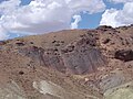
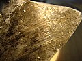
In geology, a slickenside is a smoothly polished surface caused by frictional movement between rocks along a fault. This surface is typically striated with linear features, called slickenlines, in the direction of movement. [1]

Contents

Geometry of slickensides

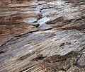
A slickenside can occur as a single surface at a fault between two hard surfaces. Alternatively, the gouge between the fault surfaces may contain many anastamosing slip surfaces that host slickensides. [2] These slip surfaces are on the order of 100 micrometers thick, [3] and the size of the grains that constitute the surface are ultra-fine (0.01-1 micrometers in diameter). [4] These grains are unlike typical grains of fault rock in that they have irregular grain boundaries and few crystal lattice defects (termed dislocations). [4]

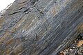
Slickensides have conspicuous shapes that can be used to determine the direction of movement along the fault. [5] Straight slickenlines indicate linear-translational fault motion. They are parallel to the direction of fault motion and serve as a kinematic indicator. [6] Curved slickenlines have recently been studied for their potential to preserve the direction of earthquake rupture propagation. [7]

Surface Roughness

Slickenside formation results in unique roughness on a slip surface. Fault surface roughness (or topography) is characterized by the aspect ratio of asperity height to scale of observation, and this roughness is a key parameter in the study of fault slip. [8] In general, a fault surface appears rougher at smaller scales (i.e. rough and bumpy at approximately millimetre scales and smaller, and increasingly smooth with larger fields of view). [9] This smoothing with larger observation scales is more pronounced in the slip-parallel direction than the slip-perpendicular direction and is commonly a result of slickenside formation.

Mechanisms to create slickensides

Mirror slickenside on scarp of Fairview Fault, Dixie Valley, Nevada, USA Fairview Fault mirror at Dixie Valley Nevada.jpg
Mirror slickenside on scarp of Fairview Fault, Dixie Valley, Nevada, USA

The unique geometry of a slickenside can be created in a variety of ways, [10] but the precise mechanisms that create them is not well understood. The grinding between two rocks produces granular material, and there is a change in the behaviour of wear material when the particle size is reduced to nanometers. [11] When the particle size is reduced so dramatically that the surface becomes shiny, it can be characterized as a fault mirror. [11]

A fault mirror may also be the result of fluid being present at the fault surface during slip. [12] Once slip has stopped, this fluid solidifies as a silica gel, which appears shiny and hosts slickenlines.

Asperity plowing

An asperity on a fault surface is a bump or point with higher relief than the area around it. The asperity, when pressed into the opposing rock surface and then moved, digs into the opposing rock, forming troughs, grooves, and scratches. [10] Asperity plowing is thus a result of permanent deformation in the brittle regime at a small scale. [13]

Debris streaking

When an asperity plows into the opposing rock, it wears itself and the opposing rock down and produces fine debris. This debris, or wear product, accumulates both in front of and behind the asperity in a long, elongated shape. If the asperity is relatively hard, the debris will accumulate in front of the asperity. If the asperity is relatively soft, the debris will trail behind. This debris hardens over time and is preserved as a form of slickenline. [10]

Erosional sheltering

Some rocks may contain particles that are harder than the rest of the rock. When these rocks are worn, the harder particles will resist wear more than the softer rock, the rock on the lee side of the hard particle will be protected from wear. This creates a tail that starts abruptly as a crag where the hard particle was located and is elongated parallel to the direction of movement down-slip from the particle. [10]

How slickenfibre steps form and show sense of movement on a fault. Slicks.png
How slickenfibre steps form and show sense of movement on a fault.

Fibre growth

The fault plane may be coated by mineral fibres that grew in during the fault movement, known as slickenfibres. Due to irregularities in the fault plane, exposed slickenfibres typically have a stepped appearance that can be used to determine the sense of movement across the fault.

Calcite-chlorite slickenfibres on a small fault cutting greenschist-facies metavolcanic rocks of the Saddlebag Lake Roof Pendant, Sierra Nevada, California Calcite-chlorite slickenfibres on a small fault slickenside.jpg
Calcite-chlorite slickenfibres on a small fault cutting greenschist-facies metavolcanic rocks of the Saddlebag Lake Roof Pendant, Sierra Nevada, California

Slickenfibres are secondary minerals that make up the slickensides rather than the rock itself. Slickenfibres form in areas where the rock slowly creep past one another rather than sliding suddenly as a result of an earthquake. [14] Unlike slickenlines, which give two possibilities for slip direction, slickenfibres preserve the true slip direction. [14]

Implications

Slickensides provide useful insight into earthquake processes. Calcite slickenfibres have recently been used to constrain the depth of aseismic creep in the Zagros Mountains as well as the orientation of stress acting on the fault. [15] It has also been suggested that when multiple slickenfibre or slickensteps orientations are present, it can indicate that the ongoing shear is not strain softening so slip does not have a constant direction. [11]

In addition to the direction of slip, slickenlines have also been used to constrain the timing of fault slip. [16] They also preserve any complexity in the geometry of the earthquake rupture. [17]

Other types of slickensides

Slickensides in soils

In pedology, the study of soils in their natural environments, a slickenside is a surface of the cracks produced in soils containing a high proportion of swelling clays. Slickensides are a type of cutan. In the Australian Soil Classification, slickensides, along with lenticular structural aggregates, are an indicator of a vertisol. [18]

Slickensides on the Moon

On the Moon, a boulder with slickensides, discovered in a debris-strewn small crater at Station 9 near Rima Hadley, was photographed during a moonwalk by the crew of Apollo 15. [19] [20] [21]


Notes

  1. Tjia, H. D. (1964). "Slickensides and Fault Movements". Geological Society of America Bulletin. 75 (7): 683–686. doi:10.1130/0016-7606(1964)75[683:SAFM]2.0.CO;2.
  2. Scholz, Christopher H. (2019). The Mechanics of Earthquakes and Faulting. Cambridge University Press. p. 128. ISBN   978-1-107-16348-5.
  3. Sagy, Amir; Brodsky, Emily E. (February 2009). "Geometric and rheological asperities in an exposed fault zone". Journal of Geophysical Research: Solid Earth. 114 (B2). Bibcode:2009JGRB..114.2301S. doi:10.1029/2008JB005701.
  4. 1 2 Power, William L.; Tullis, Terry E. (January 1989). "The relationship between slickenside surfaces in fine-grained quartz and the seismic cycle". Journal of Structural Geology. 11 (7): 879–893. Bibcode:1989JSG....11..879P. doi:10.1016/0191-8141(89)90105-3.
  5. Doblas, Miguel (September 1998). "Slickenside kinematic indicators". Tectonophysics. 295 (1–2): 187–197. Bibcode:1998Tectp.295..187D. doi:10.1016/S0040-1951(98)00120-6.
  6. Mandal, Nibir; Chakraborty, Chandan (January 1989). "Fault motion and curved slickenlines: A theoretical analysis". Journal of Structural Geology. 11 (4): 497–501. Bibcode:1989JSG....11..497M. doi:10.1016/0191-8141(89)90026-6.
  7. Kearse, Jesse; Kaneko, Yoshihiro; Little, Tim; Van Dissen, Russ (September 2019). "Curved slickenlines preserve direction of rupture propagation". Geology. 47 (9): 838–842. Bibcode:2019Geo....47..838K. doi:10.1130/G46563.1.
  8. Brodsky, Emily E.; Kirkpatrick, James D.; Candela, Thibault (January 2016). "Constraints from fault roughness on the scale-dependent strength of rocks". Geology. 44 (1): 19–22. Bibcode:2016Geo....44...19B. doi:10.1130/G37206.1.
  9. Candela, Thibault; Renard, François; Klinger, Yann; Mair, Karen; Schmittbuhl, Jean; Brodsky, Emily E. (August 2012). "Roughness of fault surfaces over nine decades of length scales". Journal of Geophysical Research: Solid Earth. 117 (B8). Bibcode:2012JGRB..117.8409C. doi:10.1029/2011JB009041.
  10. 1 2 3 4 Means, W.D. (1987). "A newly recognized type of slickenside striation". Journal of Structural Geology. 9 (5–6): 585–590. Bibcode:1987JSG.....9..585M. doi:10.1016/0191-8141(87)90143-X.
  11. 1 2 3 Toy, Virginia G.; Niemeijer, André; Renard, Francois; Morales, Luiz; Wirth, Richard (May 2017). "Striation and slickenline development on quartz fault surfaces at crustal conditions: Origin and effect on friction". Journal of Geophysical Research: Solid Earth. 122 (5): 3497–3512. Bibcode:2017JGRB..122.3497T. doi:10.1002/2016JB013498. hdl: 1874/351354 .
  12. Kirkpatrick, J.D.; Rowe, C.D.; White, J.C.; Brodsky, E.E. (September 2013). "Silica gel formation during fault slip: Evidence from the rock record". Geology. 41 (9): 1015–1018. Bibcode:2013Geo....41.1015K. doi:10.1130/G34483.1.
  13. Kirkpatrick, James D.; Brodsky, Emily E. (December 2014). "Slickenline orientations as a record of fault rock rheology". Earth and Planetary Science Letters. 408: 24–34. Bibcode:2014E&PSL.408...24K. doi:10.1016/j.epsl.2014.09.040.
  14. 1 2 Ishii, Eiichi (December 2017). "Estimation of the highest potential transmissivity of discrete shear fractures using the ductility index". International Journal of Rock Mechanics and Mining Sciences. 100: 10–22. Bibcode:2017IJRMM.100...10I. doi:10.1016/j.ijrmms.2017.10.017.
  15. Sarkarinejad, Khalil; Mottahedi, Maryam; Nori, Maryam (November 2021). "Aseismic slip on the active Sabz-Pushan and Sepidar thrusts, Iran: microstructural and kinematics evidence of the slickenline fibre creep". International Journal of Earth Sciences. 110 (8): 2831–2848. Bibcode:2021IJEaS.110.2831S. doi:10.1007/s00531-021-02081-1.
  16. Norris, D.K. (June 2001). "Slickenlines and the kinematics of the Crowsnest Deflection in the southern Rocky Mountains of Canada". Journal of Structural Geology. 23 (6–7): 1089–1102. Bibcode:2001JSG....23.1089N. doi:10.1016/S0191-8141(00)00180-2.
  17. Macklin, Clarrie; Kaneko, Yoshihiro; Kearse, Jesse (June 2021). "Coseismic slickenlines record the emergence of multiple rupture fronts during a surface-breaking earthquake". Tectonophysics. 808: 228834. Bibcode:2021Tectp.80828834M. doi:10.1016/j.tecto.2021.228834.
  18. Isbell, R. F. (1996). The Australian Soil Classification. CSIRO Australia. ISBN   978-0-643-05813-2.[ page needed ]
  19. https://www.lpi.usra.edu/resources/apollo/catalog/70mm/magazine/?82 Apollo Image Atlas (Lunar and Planetary Institute), 70 mm Hasselblad Image Catalog, Apollo 15 photographs AS15-82-11101, AS15-82-11102, AS15-82-11103 and AS15-82-11104
  20. https://www.hq.nasa.gov/alsj/a15/a15.sta9.html Apollo 15 Lunar Surface Journal – Instant Rock at Station 9
  21. https://history.nasa.gov/alsj/a15/A15SampleCat_1.pdf Catalog of Apollo 15 Rocks – Part 1. 15015-15299

Related Research Articles

<span class="mw-page-title-main">Earthquake</span> Sudden movement of the Earths crust

An earthquake – also called a quake, tremor, or temblor – is the shaking of the Earth's surface resulting from a sudden release of energy in the lithosphere that creates seismic waves. Earthquakes can range in intensity, from those so weak they cannot be felt, to those violent enough to propel objects and people into the air, damage critical infrastructure, and wreak destruction across entire cities. The seismic activity of an area is the frequency, type, and size of earthquakes experienced over a particular time. The seismicity at a particular location in the Earth is the average rate of seismic energy release per unit volume.

<span class="mw-page-title-main">Fault (geology)</span> Fracture or discontinuity in displaced rock

In geology, a fault is a planar fracture or discontinuity in a volume of rock across which there has been significant displacement as a result of rock-mass movements. Large faults within Earth's crust result from the action of plate tectonic forces, with the largest forming the boundaries between the plates, such as the megathrust faults of subduction zones or transform faults. Energy release associated with rapid movement on active faults is the cause of most earthquakes. Faults may also displace slowly, by aseismic creep.

<span class="mw-page-title-main">Alpine Fault</span> Right-lateral strike-slip fault, that runs almost the entire length of New Zealands South Island.

The Alpine Fault is a geological fault that runs almost the entire length of New Zealand's South Island, being about 600 km (370 mi). long, and forms the boundary between the Pacific Plate and the Australian Plate. The Southern Alps have been uplifted on the fault over the last 12 million years in a series of earthquakes. However, most of the motion on the fault is strike-slip, with the Tasman district and West Coast moving north and Canterbury and Otago moving south. The average slip rates in the fault's central region are about 38 mm (1.5 in) a year, very fast by global standards. The last major earthquake on the Alpine Fault was in about 1717 AD with a great earthquake magnitude of Mw8.1± 0.1. The probability of another one occurring within the next 50 years is estimated at 75 percent.

Fault friction describes the relation of friction to fault mechanics. Rock failure and associated earthquakes are very much a fractal operation. The process remains scale-invariant down to the smallest crystal. Thus, the behaviour of massive earthquakes is dependent on the properties of single molecular irregularities or asperities.

<span class="mw-page-title-main">Mylonite</span> Metamorphic rock

Mylonite is a fine-grained, compact metamorphic rock produced by dynamic recrystallization of the constituent minerals resulting in a reduction of the grain size of the rock. Mylonites can have many different mineralogical compositions; it is a classification based on the textural appearance of the rock.

Strike-slip tectonics or wrench tectonics is a type of tectonics that is dominated by lateral (horizontal) movements within the Earth's crust. Where a zone of strike-slip tectonics forms the boundary between two tectonic plates, this is known as a transform or conservative plate boundary. Areas of strike-slip tectonics are characterised by particular deformation styles including: stepovers, Riedel shears, flower structures and strike-slip duplexes. Where the displacement along a zone of strike-slip deviates from parallelism with the zone itself, the style becomes either transpressional or transtensional depending on the sense of deviation. Strike-slip tectonics is characteristic of several geological environments, including oceanic and continental transform faults, zones of oblique collision and the deforming foreland of zones of continental collision.

<span class="mw-page-title-main">Pseudotachylyte</span> Glassy, or very fine-grained, rock type

Pseudotachylyte is an extremely fine-grained to glassy, dark, cohesive rock occurring as veins that form through frictional melting and subsequent quenching during earthquakes, large-scale landslides, and impacts events. Chemical composition of pseudotachylyte generally reflects the local bulk chemistry, though may skew to slightly more mafic compositions due to the preferential incorporation of hydrous and ferro-magnesian minerals into the melt phase.

<span class="mw-page-title-main">Fault trace</span> Intersection of a geological fault with the Earths surface

A fault trace describes the intersection of a geological fault with the Earth's surface, which leaves a visible disturbance on the surface, usually looking like a crack in the surface with jagged rock structures protruding outward. The term also applies to a line plotted on a geological map to represent a fault. These fractures tend to occur when a slip surface expands from a fault core, especially during an earthquake. This tends to occur with fault displacement, in which surfaces on both sides of a fault, known as fault blocks, separate horizontally or vertically.

<span class="mw-page-title-main">Section restoration</span>

In structural geology section restoration or palinspastic restoration is a technique used to progressively undeform a geological section in an attempt to validate the interpretation used to build the section. It is also used to provide insights into the geometry of earlier stages of the geological development of an area. A section that can be successfully undeformed to a geologically reasonable geometry, without change in area, is known as a balanced section.

The 1932 Ierissos earthquake occurred at 19:20 on 26 September. It caused severe damage in Ierissos, Greece and the surrounding part of the Chalkidiki peninsula, with 161–491 casualties reported.

The sliding criterion (discontinuity) is a tool to estimate easily the shear strength properties of a discontinuity in a rock mass based on visual and tactile characterization of the discontinuity. The shear strength of a discontinuity is important in, for example, tunnel, foundation, or slope engineering, but also stability of natural slopes is often governed by the shear strength along discontinuities.

<span class="mw-page-title-main">Karakoram fault system</span> Fault system in the Himalayan region across India and Asia

The Karakoram fault is an oblique-slip fault system in the Himalayan region across India and Asia. The slip along the fault accommodates radial expansion of the Himalayan arc, northward indentation of the Pamir Mountains, and eastward lateral extrusion of the Tibetan plateau. Current plate motions suggest that the convergence between the Indian Plate and the Eurasian Plate is around 44±5 mm per year in the western Himalaya-Pamir region and approximately 50±2 mm per year in the eastern Himalayan region.

In structural geology, strain partitioning is the distribution of the total strain experienced on a rock, area, or region, in terms of different strain intensity and strain type. This process is observed on a range of scales spanning from the grain – crystal scale to the plate – lithospheric scale, and occurs in both the brittle and plastic deformation regimes. The manner and intensity by which strain is distributed are controlled by a number of factors listed below.

An earthquake occurred in southern Mongolia on December 4, 1957, measuring Mw 7.8–8.1 and assigned XII (Extreme) on the Modified Mercalli intensity scale. Surface faulting was observed in the aftermath with peak vertical and horizontal scarp reaching 9 m (30 ft). Because of the extremely sparse population in the area, this event, despite its magnitude, was not catastrophic. However, 30 people died and the towns of Dzun Bogd, Bayan-leg and Baruin Bogd were completely destroyed.

This is a compilation of the properties of different analog materials used to simulate deformational processes in structural geology. Such experiments are often called analog or analogue models. The organization of this page follows the review of rock analog materials in structural geology and tectonics of Reber et al. 2020.

<span class="mw-page-title-main">Microcracks in rock</span>

Microcracks in rock, also known as microfractures and cracks, are spaces in rock with the longest length of 1000 μm and the other two dimensions of 10 μm. In general, the ratio of width to length of microcracks is between 10−3 to 10−5.

The Gemmi Fault or Gemmi Pass Fault is a geologic fault in Switzerland. It lies close to the Gemmi Pass at Leukerbad and is a strike-slip fault. This fault is at least 2.6 kilometres (1.6 mi) long and shows evidence of Holocene movement; several landslides and traces of early Holocene earthquakes found in Swiss lakes may correlate to movements along the Gemmi Fault.

<span class="mw-page-title-main">Fault zone hydrogeology</span>

Fault zone hydrogeology is the study of how brittlely deformed rocks alter fluid flows in different lithological settings, such as clastic, igneous and carbonate rocks. Fluid movements, that can be quantified as permeability, can be facilitated or impeded due to the existence of a fault zone. This is because different mechanisms that deform rocks can alter porosity and permeability within a fault zone. Fluids involved in a fault system generally are groundwater and hydrocarbons.

The 1968 Borrego Mountain earthquake occurred on April 8, at 18:28 PST in the geologically active Salton Trough of Southern California. The Salton Trough represents a pull-apart basin formed by movements along major faults. This region is dominated by major strike-slip faults one of them being the San Jacinto Fault which produced the 1968 earthquake. The mainshock's epicenter was near the unincorporated community of Ocotillo Wells in San Diego County. The moment magnitude (Mw ) 6.6 strike-slip earthquake struck with a focal depth of 11.1 km (6.9 mi). The zone of surface rupture was assigned a maximum Modified Mercalli intensity (MMI) of VII.

<span class="mw-page-title-main">Earthquake cycle</span>

The earthquake cycle refers to the phenomenon that earthquakes repeatedly occur on the same fault as the result of continual stress accumulation and periodic stress release. Earthquake cycles can occur on a variety of faults including subduction zones and continental faults. Depending on the size of the earthquake, an earthquake cycle can last decades, centuries, or longer. The Parkfield portion of the San Andreas fault is a well-known example where similarly located M6.0 earthquakes have been instrumentally recorded every 30–40 years.

References