Geotechnical engineering, also known as geotechnics, is the branch of civil engineering concerned with the engineering behavior of earth materials. It uses the principles of soil mechanics and rock mechanics to solve its engineering problems. It also relies on knowledge of geology, hydrology, geophysics, and other related sciences.

A borehole is a narrow shaft bored in the ground, either vertically or horizontally. A borehole may be constructed for many different purposes, including the extraction of water, other liquids, or gases. It may also be part of a geotechnical investigation, environmental site assessment, mineral exploration, temperature measurement, as a pilot hole for installing piers or underground utilities, for geothermal installations, or for underground storage of unwanted substances, e.g. in carbon capture and storage.
Engineering geology is the application of geology to engineering study for the purpose of assuring that the geological factors regarding the location, design, construction, operation and maintenance of engineering works are recognized and accounted for. Engineering geologists provide geological and geotechnical recommendations, analysis, and design associated with human development and various types of structures. The realm of the engineering geologist is essentially in the area of earth-structure interactions, or investigation of how the earth or earth processes impact human made structures and human activities.
Rock mass classification systems are used for various engineering design and stability analysis. These are based on empirical relations between rock mass parameters and engineering applications, such as tunnels, slopes, foundations, and excavatability. The first rock mass classification system in geotechnical engineering was proposed in 1946 for tunnels with steel set support.
Exploration geophysics is an applied branch of geophysics and economic geology, which uses physical methods at the surface of the Earth, such as seismic, gravitational, magnetic, electrical and electromagnetic, to measure the physical properties of the subsurface, along with the anomalies in those properties. It is most often used to detect or infer the presence and position of economically useful geological deposits, such as ore minerals; fossil fuels and other hydrocarbons; geothermal reservoirs; and groundwater reservoirs. It can also be used to detect the presence of unexploded ordnance.
Geomechanics is the study of the mechanical state of the Earth's crust and the processes occurring in it under the influence of natural physical factors. It involves the study of the mechanics of soil and rock.
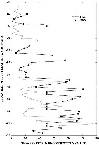
The standard penetration test (SPT) is an in-situ dynamic penetration test designed to provide information on the geotechnical engineering properties of soil. This test is the most frequently used subsurface exploration drilling test performed worldwide. The test procedure is described in ISO 22476-3, ASTM D1586 and Australian Standards AS 1289.6.3.1. The test provides samples for identification purposes and provides a measure of penetration resistance which can be used for geotechnical design purposes. Various local and widely published international correlations that relate blow count, or N-value, to the engineering properties of soils are available for geotechnical engineering purposes.
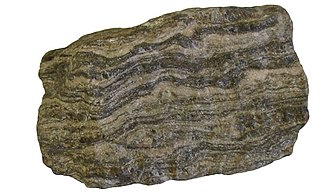
Foliation in geology refers to repetitive layering in metamorphic rocks. Each layer can be as thin as a sheet of paper, or over a meter in thickness. The word comes from the Latin folium, meaning "leaf", and refers to the sheet-like planar structure. It is caused by shearing forces, or differential pressure. The layers form parallel to the direction of the shear, or perpendicular to the direction of higher pressure. Nonfoliated metamorphic rocks are typically formed in the absence of significant differential pressure or shear. Foliation is common in rocks affected by the regional metamorphic compression typical of areas of mountain belt formation.
A direct shear test is a laboratory or field test used by geotechnical engineers to measure the shear strength properties of soil or rock material, or of discontinuities in soil or rock masses.

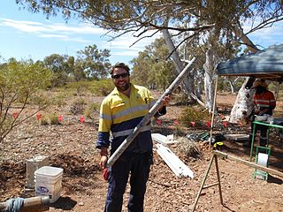
Geotechnical investigations are performed by geotechnical engineers or engineering geologists to obtain information on the physical properties of soil earthworks and foundations for proposed structures and for repair of distress to earthworks and structures caused by subsurface conditions; this type of investigation is called a site investigation. Geotechnical investigations are also used to measure the thermal resistance of soils or backfill materials required for underground transmission lines, oil and gas pipelines, radioactive waste disposal, and solar thermal storage facilities. A geotechnical investigation will include surface exploration and subsurface exploration of a site. Sometimes, geophysical methods are used to obtain data about sites. Subsurface exploration usually involves soil sampling and laboratory tests of the soil samples retrieved.
BS 5930:2015, "the code of practice for site investigations", is a UK code of practice which came into effect on 31 July 2015 British Standards Institution.
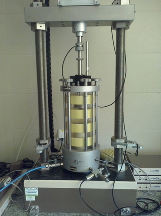
A triaxial shear test is a common method to measure the mechanical properties of many deformable solids, especially soil and rock, and other granular materials or powders. There are several variations on the test.

Boring is drilling a hole, tunnel, or well in the Earth. It is used for various applications in geology, agriculture, hydrology, civil engineering, and mineral exploration. Today, most Earth drilling serves one of the following purposes:
Geoprofessions is a term coined by the Geoprofessional Business Association to connote various technical disciplines that involve engineering, earth and environmental services applied to below-ground ("subsurface"), ground-surface, and ground-surface-connected conditions, structures, or formations. The principal disciplines include, as major categories:
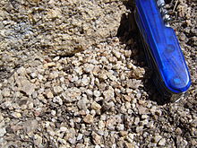
A discontinuity in geotechnical engineering is a plane or surface that marks a change in physical or chemical characteristics in a soil or rock mass. A discontinuity can be, for example, a bedding, schistosity, foliation, joint, cleavage, fracture, fissure, crack, or fault plane. A division is made between mechanical and integral discontinuities. Discontinuities may occur multiple times with broadly the same mechanical characteristics in a discontinuity set, or may be a single discontinuity. A discontinuity makes a soil or rock mass anisotropic.
In geotechnical engineering and contact mechanics the term asperity is used to refer to individual features of unevenness (roughness) of the surface of a discontinuity, grain, or particle with heights in the range from approximately 0.1 mm to the order of metres. Below the asperity level, surface interactions are normally considered to be a material property, arising from mechanisms of adhesion and repulsion at the atomic scale.
The rock mass rating (RMR) is a geomechanical classification system for rocks, developed by Z. T. Bieniawski between 1972 and 1973. Since then it has undergone multiple modifications out of which, RMR89 is commonly used. Recently RMR14 has been proposed to improve the RMR performance by incorporating new experiences from tunnel practices. Continuous functions and a software "QuickRMR" for RMR89 and RMR14 have also been proposed by Kundu. RMR combines the most significant geologic parameters of influence and represents them with one overall comprehensive index of rock mass quality, which is used for the design and construction of excavations in rock, such as tunnels, mines, slopes, and foundations.
The shear strength of a discontinuity in a soil or rock mass may have a strong impact on the mechanical behavior of a soil or rock mass. The shear strength of a discontinuity is often considerably lower than the shear strength of the blocks of intact material in between the discontinuities, and therefore influences, for example, tunnel, foundation, or slope engineering, but also the stability of natural slopes. Many slopes, natural and man-made, fail due to a low shear strength of discontinuities in the soil or rock mass in the slope. The deformation characteristics of a soil or rock mass are also influenced by the shear strength of the discontinuities. For example, the modulus of deformation is reduced, and the deformation becomes plastic rather than elastic. This may cause, for example, larger settlement of foundations, which is also permanent even if the load is only temporary. Furthermore, the shear strength of discontinuities influences the stress distribution in a soil or rock mass.

Persistence determines the possibilities of relative movement along a discontinuity in a soil or rock mass in geotechnical engineering. Discontinuities are usually differentiated in persistent, non-persistent, and abutting discontinuities (figure).

Geological engineering is a discipline of engineering concerned with the application of geological science and engineering principles to fields, such as civil engineering, mining, environmental engineering, and forestry, among others. The work of geological engineers often directs or supports the work of other engineering disciplines such as assessing the suitability of locations for civil engineering, environmental engineering, mining operations, and oil and gas projects by conducting geological, geoenvironmental, geophysical, and geotechnical studies. They are involved with impact studies for facilities and operations that affect surface and subsurface environments. The engineering design input and other recommendations made by geological engineers on these projects will often have a large impact on construction and operations. Geological engineers plan, design, and implement geotechnical, geological, geophysical, hydrogeological, and environmental data acquisition. This ranges from manual ground-based methods to deep drilling, to geochemical sampling, to advanced geophysical techniques and satellite surveying. Geological engineers are also concerned with the analysis of past and future ground behaviour, mapping at all scales, and ground characterization programs for specific engineering requirements. These analyses lead geological engineers to make recommendations and prepare reports which could have major effects on the foundations of construction, mining, and civil engineering projects. Some examples of projects include rock excavation, building foundation consolidation, pressure grouting, hydraulic channel erosion control, slope and fill stabilization, landslide risk assessment, groundwater monitoring, and assessment and remediation of contamination. In addition, geological engineers are included on design teams that develop solutions to surface hazards, groundwater remediation, underground and surface excavation projects, and resource management. Like mining engineers, geological engineers also conduct resource exploration campaigns, mine evaluation and feasibility assessments, and contribute to the ongoing efficiency, sustainability, and safety of active mining projects