List of tectonic plate interactions

Last updated
Three types of plate boundary Tectonic plate boundaries.png
Three types of plate boundary
Convergent boundary Continental-continental destructive plate boundary.svg
Convergent boundary
Divergent boundary Continental-continental constructive plate boundary.svg
Divergent boundary
Transform boundary Continental-continental conservative plate boundary opposite directions.svg
Transform boundary

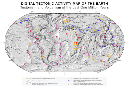
Tectonic plate interactions are classified into three basic types: [1]

Contents

Convergent boundaries (subduction zones)

Back arc basins

Orogenic belts

Divergent boundaries

Plate tectonics map Plate tectonics map.gif
Plate tectonics map

Transform boundaries

See also

Related Research Articles

<span class="mw-page-title-main">Oceanic trench</span> Long and narrow depressions of the sea floor

Oceanic trenches are prominent, long, narrow topographic depressions of the ocean floor. They are typically 50 to 100 kilometers wide and 3 to 4 km below the level of the surrounding oceanic floor, but can be thousands of kilometers in length. There are about 50,000 km (31,000 mi) of oceanic trenches worldwide, mostly around the Pacific Ocean, but also in the eastern Indian Ocean and a few other locations. The greatest ocean depth measured is in the Challenger Deep of the Mariana Trench, at a depth of 10,920 m (35,830 ft) below sea level.

<span class="mw-page-title-main">Subduction</span> A geological process at convergent tectonic plate boundaries where one plate moves under the other

Subduction is a geological process in which the oceanic lithosphere and some continental lithosphere is recycled into the Earth's mantle at convergent boundaries. Where the oceanic lithosphere of a tectonic plate converges with the less dense lithosphere of a second plate, the heavier plate dives beneath the second plate and sinks into the mantle. A region where this process occurs is known as a subduction zone, and its surface expression is known as an arc-trench complex. The process of subduction has created most of the Earth's continental crust. Rates of subduction are typically measured in centimeters per year, with rates of convergence as high as 11 cm/year.

Obduction is a geological process whereby denser oceanic crust is scraped off a descending ocean plate at a convergent plate boundary and thrust on top of an adjacent plate. When oceanic and continental plates converge, normally the denser oceanic crust sinks under the continental crust in the process of subduction. Obduction, which is less common, normally occurs in plate collisions at orogenic belts or back-arc basins.

<span class="mw-page-title-main">Convergent boundary</span> Region of active deformation between colliding tectonic plates

A convergent boundary is an area on Earth where two or more lithospheric plates collide. One plate eventually slides beneath the other, a process known as subduction. The subduction zone can be defined by a plane where many earthquakes occur, called the Wadati–Benioff zone. These collisions happen on scales of millions to tens of millions of years and can lead to volcanism, earthquakes, orogenesis, destruction of lithosphere, and deformation. Convergent boundaries occur between oceanic-oceanic lithosphere, oceanic-continental lithosphere, and continental-continental lithosphere. The geologic features related to convergent boundaries vary depending on crust types.

<span class="mw-page-title-main">North American Plate</span> Large tectonic plate including most of North America, Greenland and part of Siberia

The North American Plate is a tectonic plate covering most of North America, Cuba, the Bahamas, extreme northeastern Asia, and parts of Iceland and the Azores. With an area of 76 million km2 (29 million sq mi), it is the Earth's second largest tectonic plate, behind the Pacific Plate.

<span class="mw-page-title-main">Pacific Plate</span> Oceanic tectonic plate under the Pacific Ocean

The Pacific Plate is an oceanic tectonic plate that lies beneath the Pacific Ocean. At 103 million km2 (40 million sq mi), it is the largest tectonic plate.

<span class="mw-page-title-main">Cocos Plate</span> Young oceanic tectonic plate beneath the Pacific Ocean off the west coast of Central America

The Cocos Plate is a young oceanic tectonic plate beneath the Pacific Ocean off the west coast of Central America, named for Cocos Island, which rides upon it. The Cocos Plate was created approximately 23 million years ago when the Farallon Plate broke into two pieces, which also created the Nazca Plate. The Cocos Plate also broke into two pieces, creating the small Rivera Plate. The Cocos Plate is bounded by several different plates. To the northeast it is bounded by the North American Plate and the Caribbean Plate. To the west it is bounded by the Pacific Plate and to the south by the Nazca Plate.

<span class="mw-page-title-main">Australian Plate</span> Major tectonic plate separated from Indo-Australian Plate about 3 million years ago

The Australian Plate is a major tectonic plate in the eastern and, largely, southern hemispheres. Originally a part of the ancient continent of Gondwana, Australia remained connected to India and Antarctica until approximately 100 million years ago when India broke away and began moving north. Australia and Antarctica had begun rifting by 96 million years ago and completely separated a while after this, some believing as recently as 45 million years ago, but most accepting presently that this had occurred by 60 million years ago.

<span class="mw-page-title-main">Geology of Japan</span> Overview of the geology of Japan

The islands of Japan are primarily the result of several large ocean movements occurring over hundreds of millions of years from the mid-Silurian to the Pleistocene, as a result of the subduction of the Philippine Sea Plate beneath the continental Amurian Plate and Okinawa Plate to the south, and subduction of the Pacific Plate under the Okhotsk Plate to the north.

The Tonga Plate is a small southwest Pacific tectonic plate or microplate. It is centered at approximately 19° S. latitude and 173° E. longitude. The plate is an elongated plate oriented NNE - SSW and is a northward continuation of the Kermadec linear zone north of New Zealand. The plate is bounded on the east and north by the Pacific Plate, on the northwest by the Niuafo’ou Microplate, on the west and south by the Indo-Australian Plate. The Tonga plate is subducting the Pacific plate along the Tonga Trench. This subduction turns into a transform fault boundary north of Tonga. An active rift or spreading center separates the Tonga Plate from the Australian Plate and the Niuafo’ou microplate to the west. The Tonga Plate is seismically very active and is rotating clockwise.

The Hunter-Bowen Orogeny was a significant arc accretion event in the Permian and Triassic periods affecting approximately 2,500 km of the Australian continental margin.

<span class="mw-page-title-main">Izu–Bonin–Mariana Arc</span> Convergent boundary in Micronesia

The Izu–Bonin–Mariana (IBM) arc system is a tectonic plate convergent boundary in Micronesia. The IBM arc system extends over 2800 km south from Tokyo, Japan, to beyond Guam, and includes the Izu Islands, the Bonin Islands, and the Mariana Islands; much more of the IBM arc system is submerged below sealevel. The IBM arc system lies along the eastern margin of the Philippine Sea Plate in the Western Pacific Ocean. It is the site of the deepest gash in Earth's solid surface, the Challenger Deep in the Mariana Trench.

<span class="mw-page-title-main">Accretionary wedge</span> The sediments accreted onto the non-subducting tectonic plate at a convergent plate boundary

An accretionary wedge or accretionary prism forms from sediments accreted onto the non-subducting tectonic plate at a convergent plate boundary. Most of the material in the accretionary wedge consists of marine sediments scraped off from the downgoing slab of oceanic crust, but in some cases the wedge includes the erosional products of volcanic island arcs formed on the overriding plate.

<span class="mw-page-title-main">Kermadec-Tonga subduction zone</span> Convergent plate boundary that stretches from the North Island of New Zealand northward

The Kermadec-Tonga subduction zone is a convergent plate boundary that stretches from the North Island of New Zealand northward. The formation of the Kermadec and Tonga Plates started about 4–5 million years ago. Today, the eastern boundary of the Tonga Plate is one of the fastest subduction zones, with a rate up to 24 cm/yr. The trench formed between the Kermadec-Tonga and Pacific Plates is also home to the second deepest trench in the world, at about 10,800 m, as well as the longest chain of submerged volcanoes.

<span class="mw-page-title-main">Caroline Plate</span> Minor oceanic tectonic plate north of New Guinea

The Caroline Plate is a minor tectonic plate that straddles the Equator in the eastern hemisphere located north of New Guinea. It forms a subduction zone along the border with the Bird's Head Plate and other minor plates of the New Guinea region to the south. A transform boundary forms the northern border with the Pacific Plate. Along the border with the Philippine Sea Plate is a convergent boundary that transitions into a rift.

<span class="mw-page-title-main">Mariana Plate</span> Small tectonic plate west of the Mariana Trench

The Mariana Plate is a micro tectonic plate located west of the Mariana Trench which forms the basement of the Mariana Islands which form part of the Izu–Bonin–Mariana Arc. It is separated from the Philippine Sea Plate to the west by a divergent boundary with numerous transform fault offsets. The boundary between the Mariana and the Pacific Plate to the east is a subduction zone with the Pacific Plate subducting beneath the Mariana. This eastern subduction is divided into the Mariana Trench, which forms the southeastern boundary, and the Izu–Ogasawara Trench the northeastern boundary. The subduction plate motion is responsible for the shape of the Mariana plate and back arc.

This is a list of articles related to plate tectonics and tectonic plates.

<span class="mw-page-title-main">Philippine Mobile Belt</span> Tectonic boundary

In the geology of the Philippines, the Philippine Mobile Belt is a complex portion of the tectonic boundary between the Eurasian Plate and the Philippine Sea Plate, comprising most of the country of the Philippines. It includes two subduction zones, the Manila Trench to the west and the Philippine Trench to the east, as well as the Philippine Fault System. Within the Belt, a number of crustal blocks or microplates which have been shorn off the adjoining major plates are undergoing massive deformation.

<span class="mw-page-title-main">Geology of the Pacific Ocean</span> Overview about the geology of the Pacific Ocean

The Pacific Ocean evolved in the Mesozoic from the Panthalassic Ocean, which had formed when Rodinia rifted apart around 750 Ma. The first ocean floor which is part of the current Pacific Plate began 160 Ma to the west of the central Pacific and subsequently developed into the largest oceanic plate on Earth.

<span class="mw-page-title-main">North Fiji Basin</span>

The North Fiji Basin (NFB) is an oceanic basin west of Fiji in the south-west Pacific Ocean. It is an actively spreading back-arc basin delimited by the Fiji islands to the east, the inactive Vitiaz Trench to the north, the Vanuatu/New Hebrides island arc to the west, and the Hunter fracture zone to the south. Roughly triangular in shape with its apex located at the northern end of the New Hebrides Arc, the basin is actively spreading southward and is characterised by three spreading centres and an oceanic crust younger than 12 Ma. The opening of the NFB began when a slab roll-back was initiated beneath the New Hebrides and the island arc started its clockwise rotation. The opening of the basin was the result of the collision between the Ontong Java Plateau and the Australian Plate along the now inactive Solomon–Vitiaz subduction system north of the NFB. The NFB is the largest and most developed back-arc basin of the south-west Pacific. It is opening in a complex geological setting between two oppositely verging subduction systems, the New Hebrides/Vanuatu and Tonga trenches and hence its ocean floor has the World's largest amount of spreading centres per area.

References

  1. "Tectonic Plates and Plate Boundaries". GNS Science . Retrieved 2014-09-12.
  2. Karig, Daniel E (1970). "Ridges and basins of the Tonga-Kermadec island arc system". Journal of Geophysical Research. 75 (2): 239–254. Bibcode:1970JGR....75..239K. doi:10.1029/JB075i002p00239.