Oceanic trenches are prominent, long, narrow topographic depressions of the ocean floor. They are typically 50 to 100 kilometers wide and 3 to 4 km below the level of the surrounding oceanic floor, but can be thousands of kilometers in length. There are about 50,000 km (31,000 mi) of oceanic trenches worldwide, mostly around the Pacific Ocean, but also in the eastern Indian Ocean and a few other locations. The greatest ocean depth measured is in the Challenger Deep of the Mariana Trench, at a depth of 10,920 m (35,830 ft) below sea level.
Subduction is a geological process in which the oceanic lithosphere and some continental lithosphere is recycled into the Earth's mantle at convergent boundaries. Where the oceanic lithosphere of a tectonic plate converges with the less dense lithosphere of a second plate, the heavier plate dives beneath the second plate and sinks into the mantle. A region where this process occurs is known as a subduction zone, and its surface expression is known as an arc-trench complex. The process of subduction has created most of the Earth's continental crust. Rates of subduction are typically measured in centimeters per year, with rates of convergence as high as 11 cm/year.
Obduction is a geological process whereby denser oceanic crust is scraped off a descending ocean plate at a convergent plate boundary and thrust on top of an adjacent plate. When oceanic and continental plates converge, normally the denser oceanic crust sinks under the continental crust in the process of subduction. Obduction, which is less common, normally occurs in plate collisions at orogenic belts or back-arc basins.

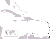
The Lesser Antilles are a group of islands in the Caribbean Sea. They are distinguished from the large islands of the Greater Antilles to the west. They form an arc which begins east of Puerto Rico and swings south through the Leeward and Windward Islands almost to South America and then turns west along the Venezuelan coast as far as Aruba. Barbados is isolated about 100 miles east of the Windwards.

A convergent boundary is an area on Earth where two or more lithospheric plates collide. One plate eventually slides beneath the other, a process known as subduction. The subduction zone can be defined by a plane where many earthquakes occur, called the Wadati–Benioff zone. These collisions happen on scales of millions to tens of millions of years and can lead to volcanism, earthquakes, orogenesis, destruction of lithosphere, and deformation. Convergent boundaries occur between oceanic-oceanic lithosphere, oceanic-continental lithosphere, and continental-continental lithosphere. The geologic features related to convergent boundaries vary depending on crust types.

Island arcs are long chains of active volcanoes with intense seismic activity found along convergent tectonic plate boundaries. Most island arcs originate on oceanic crust and have resulted from the descent of the lithosphere into the mantle along the subduction zone. They are the principal way by which continental growth is achieved.
A volcanic arc is a belt of volcanoes formed above a subducting oceanic tectonic plate, with the belt arranged in an arc shape as seen from above. Volcanic arcs typically parallel an oceanic trench, with the arc located further from the subducting plate than the trench. The oceanic plate is saturated with water, mostly in the form of hydrous minerals such as micas, amphiboles, and serpentines. As the oceanic plate is subducted, it is subjected to increasing pressure and temperature with increasing depth. The heat and pressure break down the hydrous minerals in the plate, releasing water into the overlying mantle. Volatiles such as water drastically lower the melting point of the mantle, causing some of the mantle to melt and form magma at depth under the overriding plate. The magma ascends to form an arc of volcanoes parallel to the subduction zone.
Megathrust earthquakes occur at convergent plate boundaries, where one tectonic plate is forced underneath another. The earthquakes are caused by slip along the thrust fault that forms the contact between the two plates. These interplate earthquakes are the planet's most powerful, with moment magnitudes (Mw) that can exceed 9.0. Since 1900, all earthquakes of magnitude 9.0 or greater have been megathrust earthquakes.

The Caribbean Plate is a mostly oceanic tectonic plate underlying Central America and the Caribbean Sea off the northern coast of South America.
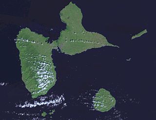
Guadeloupe is an archipelago of more than 12 islands, as well as islets and rocks situated where the northeastern Caribbean Sea meets the western Atlantic Ocean. It is located in the Leeward Islands in the northern part of the Lesser Antilles, a partly volcanic island arc. To the north lie Antigua and Barbuda and the British Overseas Territory of Montserrat, with Dominica lying to the south.
In geology, accretion is a process by which material is added to a tectonic plate at a subduction zone, frequently on the edge of existing continental landmasses. The added material may be sediment, volcanic arcs, seamounts, oceanic crust or other igneous features.

The West Indies is a subregion of North America, surrounded by the North Atlantic Ocean and the Caribbean Sea, which comprises 13 independent island countries and 19 dependencies in three archipelagos: the Greater Antilles, the Lesser Antilles, and the Lucayan Archipelago.

The Leeward Antilles are a chain of islands in the Caribbean – specifically the southerly islands of the Lesser Antilles along the southeastern fringe of the Caribbean Sea, just north of the Venezuelan coast of the South American mainland. The Leeward Antilles, while among the Lesser Antilles, are not to be confused with the Leeward Islands to the northeast.
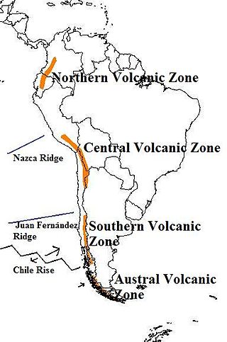
The Andean Volcanic Belt is a major volcanic belt along the Andean cordillera in Argentina, Bolivia, Chile, Colombia, Ecuador, and Peru. It is formed as a result of subduction of the Nazca Plate and Antarctic Plate underneath the South American Plate. The belt is subdivided into four main volcanic zones which are separated by volcanic gaps. The volcanoes of the belt are diverse in terms of activity style, products, and morphology. While some differences can be explained by which volcanic zone a volcano belongs to, there are significant differences within volcanic zones and even between neighboring volcanoes. Despite being a type location for calc-alkalic and subduction volcanism, the Andean Volcanic Belt has a broad range of volcano-tectonic settings, as it has rift systems and extensional zones, transpressional faults, subduction of mid-ocean ridges and seamount chains as well as a large range of crustal thicknesses and magma ascent paths and different amounts of crustal assimilations.
The Azores–Gibraltar Transform Fault (AGFZ), also called a fault zone and a fracture zone, is a major seismic zone in the Eastern Atlantic Ocean between the Azores and the Strait of Gibraltar. It is the product of the complex interaction between the African, Eurasian, and Iberian plates. The AGFZ produced these large-magnitude earthquakes and, consequently, a number of large tsunamis: 1755 Lisbon, 1761 Lisbon, 1816 North Atlantic, 1941 Gloria Fault earthquake, 1969 Horseshoe and 1975.

The Lesser Antilles Volcanic Arc is a volcanic arc that forms the eastern boundary of the Caribbean Plate. It is part of a subduction zone, also known as the Lesser Antilles subduction zone, where the oceanic crust of the North American Plate is being subducted under the Caribbean Plate. This subduction process formed a number of volcanic islands, from the Virgin Islands in the north to the islands off the coast of Venezuela in the south. The Lesser Antilles Volcanic Arc includes 21 'active' volcanoes, notably Soufriere Hills on Montserrat; Mount Pelée on Martinique; La Grande Soufrière on Guadeloupe; Soufrière Saint Vincent on Saint Vincent; Mount Scenery on Saba; and the submarine volcano Kick 'em Jenny which lies about 10 kilometres (5.4 nmi) north of Grenada.
The 1974 Lesser Antilles earthquake occurred at on October 8 with a moment magnitude of 6.9 and a maximum Mercalli intensity of VIII (Severe). Four people were injured in what the United States' National Geophysical Data Center called a moderately destructive event.

The Grenada Basin is an 11–15 km thick back-arc sedimentary basin located in the southeastern region of the Caribbean Sea. It is bordered by the Lesser Antilles in the north, south, and east, and the Aves Ridge in the west.
The 1839 Martinique earthquake occurred on the morning of January 11 with an estimated magnitude of 7.8 Ms , the largest in the Lesser Antilles since 1690. The maximum intensity of this earthquake was assigned IX on both the Mercalli and MSK intensity scales, which left the cities of Saint-Pierre and Fort Royal almost completely destroyed. Estimation on the number of human losses varies from 390 to even 4,000 making this one of the deadliest earthquakes in the Caribbean.
Venezuela and Trinidad were struck by a major earthquake on 21 October 1766 at 4:30 in the morning local time in Cumaná, Venezuela. It caused widespread damage from Caracas in the west to Georgetown, Guyana in the east. Despite the significant damage caused, there are no reports of casualties associated with this earthquake. It had an estimated magnitude in the range 6.5–7.5 and a maximum felt intensity of IX-X on the European macroseismic scale. It was felt from Guadeloupe in the north to the Ventuari River in the south and Maracaibo in the west and Kaw, French Guiana in the east.