
An earthquake – also called a quake, tremor, or temblor – is the shaking of the Earth's surface resulting from a sudden release of energy in the lithosphere that creates seismic waves. Earthquakes can range in intensity, from those so weak they cannot be felt, to those violent enough to propel objects and people into the air, damage critical infrastructure, and wreak destruction across entire cities. The seismic activity of an area is the frequency, type, and size of earthquakes experienced over a particular time. The seismicity at a particular location in the Earth is the average rate of seismic energy release per unit volume.

The San Andreas Fault is a continental right-lateral strike-slip transform fault that extends roughly 1,200 kilometers (750 mi) through the U.S. state of California. It forms part of the tectonic boundary between the Pacific Plate and the North American Plate. Traditionally, for scientific purposes, the fault has been classified into three main segments, each with different characteristics and a different degree of earthquake risk. The average slip rate along the entire fault ranges from 20 to 35 mm per year.

The Cascadia subduction zone is a 960 km (600 mi) fault at a convergent plate boundary, about 100–200 km (70–100 mi) off the Pacific coast, that stretches from northern Vancouver Island in Canada to Northern California in the United States. It is capable of producing 9.0+ magnitude earthquakes and tsunamis that could reach 30 m (98 ft). The Oregon Department of Emergency Management estimates shaking would last 5–7 minutes along the coast, with strength and intensity decreasing further from the epicenter. It is a very long, sloping subduction zone where the Explorer, Juan de Fuca, and Gorda plates move to the east and slide below the much larger mostly continental North American plate. The zone varies in width and lies offshore beginning near Cape Mendocino, Northern California, passing through Oregon and Washington, and terminating at about Vancouver Island in British Columbia.
An interplate earthquake is an earthquake that occurs at the boundary between two tectonic plates. Earthquakes of this type account for more than 90 percent of the total seismic energy released around the world. If one plate is trying to move past the other, they will be locked until sufficient stress builds up to cause the plates to slip relative to each other. The slipping process creates an earthquake with relative displacement on either side of the fault, resulting in seismic waves which travel through the Earth and along the Earth's surface. Relative plate motion can be lateral as along a transform fault boundary, vertical if along a convergent boundary or a divergent boundary, and oblique, with horizontal and lateral components at the boundary. Interplate earthquakes associated at a subduction boundary are called megathrust earthquakes, which include most of the Earth's largest earthquakes.
Megathrust earthquakes occur at convergent plate boundaries, where one tectonic plate is forced underneath another. The earthquakes are caused by slip along the thrust fault that forms the contact between the two plates. These interplate earthquakes are the planet's most powerful, with moment magnitudes (Mw) that can exceed 9.0. Since 1900, all earthquakes of magnitude 9.0 or greater have been megathrust earthquakes.
In tectonics, vertical displacement refers to the shifting of land in a vertical direction, resulting in uplift and subsidence. The displacement of rock layers can provide information on how and why Earth's lithosphere changes throughout geologic time. There are different mechanisms which lead to vertical displacement such as tectonic activity, and isostatic adjustments. Tectonic activity leads to vertical displacement when crust is rearranged during a seismic event. Isostatic adjustments result in vertical displacement through sinking due to an increased load or isostatic rebound due to load removal.
Strike-slip tectonics or wrench tectonics is a type of tectonics that is dominated by lateral (horizontal) movements within the Earth's crust. Where a zone of strike-slip tectonics forms the boundary between two tectonic plates, this is known as a transform or conservative plate boundary. Areas of strike-slip tectonics are characterised by particular deformation styles including: stepovers, Riedel shears, flower structures and strike-slip duplexes. Where the displacement along a zone of strike-slip deviates from parallelism with the zone itself, the style becomes either transpressional or transtensional depending on the sense of deviation. Strike-slip tectonics is characteristic of several geological environments, including oceanic and continental transform faults, zones of oblique collision and the deforming foreland of zones of continental collision.
The Queen Charlotte Fault is an active transform fault that marks the boundary of the North American plate and the Pacific plate. It is Canada's right-lateral strike-slip equivalent to the San Andreas Fault to the south in California. The Queen Charlotte Fault forms a triple junction south with the Cascadia subduction zone and the Explorer Ridge. The Queen Charlotte Fault (QCF) forms a transpressional plate boundary, and is as active as other major transform fault systems in terms of slip rates and seismogenic potential. It sustains the highest known deformation rates among continental or continent-ocean transform systems globally, accommodating greater than 50mm/yr dextral offset. The entire approximately 900 km offshore length has ruptured in seven greater than magnitude 7 events during the last century, making the cumulative historical seismic moment release higher than any other modern transform plate boundary system.

The 1976 Guatemala earthquake struck on February 4 at with a moment magnitude of 7.5. The shock was centered on the Motagua Fault, about 160 km northeast of Guatemala City at a depth of 5 kilometers (3.1 mi) near the town of Los Amates in the department of Izabal.
The Walker Lane is a geologic trough roughly aligned with the California/Nevada border southward to where Death Valley intersects the Garlock Fault, a major left lateral, or sinistral, strike-slip fault. The north-northwest end of the Walker Lane is between Pyramid Lake in Nevada and California's Lassen Peak where the Honey Lake Fault Zone, the Warm Springs Valley Fault, and the Pyramid Lake Fault Zone meet the transverse tectonic zone forming the southern boundary of the Modoc Plateau and Columbia Plateau provinces. The Walker Lane takes up 15 to 25 percent of the boundary motion between the Pacific Plate and the North American Plate, the other 75 percent being taken up by the San Andreas Fault system to the west. The Walker Lane may represent an incipient major transform fault zone which could replace the San Andreas as the plate boundary in the future.

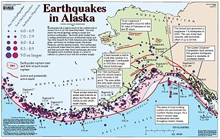
The 2002 Denali earthquake occurred at 22:12:41 UTC November 3 with an epicenter 66 km ESE of Denali National Park, Alaska, United States. This 7.9 Mw earthquake was the largest recorded in the United States in 37 years. The shock was the strongest ever recorded in the interior of Alaska. Due to the remote location, there were no fatalities and only one injury.

Isabel Pass is a 40 mile long gap in the eastern section of the Alaska Range which serves as a corridor for the Richardson Highway about 11 miles from Paxson. It is named after Isabelle Barnette, the wife of E. T. Barnette, who helped found Fairbanks. The pass separates four regions, the Tanana Valley to the north, the Delta Mountains to the east, Copper River Basin to the south, and the Hayes Range to the west.
The 1843 Whanganui earthquake occurred on 8 July at 16:45 local time with an estimated magnitude of 7.5 on the scale. The maximum perceived intensity was IX (Violent) on the Mercalli intensity scale, and possibly reaching X (Extreme). The epicentre is estimated to have been within a zone extending 50 km northeast from Whanganui towards Taihape. GNS Science has this earthquake catalogued and places the epicentre 35 km east of Taihape, near the border of Hawke's Bay. This was the first earthquake in New Zealand over magnitude 7 for which written records exist, and the first for which deaths were recorded.
The Philippine fault system is a major inter-related system of geological faults throughout the whole of the Philippine Archipelago, primarily caused by tectonic forces compressing the Philippines into what geophysicists call the Philippine Mobile Belt. Some notable Philippine faults include the Guinayangan, Masbate and Leyte faults.
The Tintina Fault is a large right-lateral strike-slip fault in western North America, extending from Flathead Lake, Montana to the centre of the U.S. state of Alaska. It represents the Yukon continuum between the Rocky Mountain Trench in the northern United States and the Kaltag Fault in Alaska.
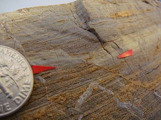
In geology, a piercing point is defined as a feature that is cut by a fault, then moved apart. Reconfiguring the piercing point back in its original position is the primary way geologists can find out the minimum slip, or displacement, along a fault. This can be done on a large scale, a small scale or even a single hand sample/rock.

The El Tigre Fault is a 120 km long, roughly north-south trending, major strike-slip fault located in the Western Precordillera in Argentina. The Precordillera lies just to the east of the Andes mountain range in South America. The northern boundary of the fault is the Jáchal River and its southern boundary is the San Juan River. The fault is divided into three sections based on fault trace geometry, Northern extending between 41–46 km in length, Central extending between 48–53 km in length, and Southern extending 26 km in length. The fault displays a right-lateral (horizontal) motion and has formed in response to stresses from the Nazca Plate subducting under the South American Plate. It is a major fault with crustal significance. The Andes Mountain belt trends with respect to the Nazca Plate/South American Plate convergence zone, and deformation is divided between the Precordilleran thrust faults and the El Tigre strike-slip motion. The El Tigre Fault is currently seismically active.
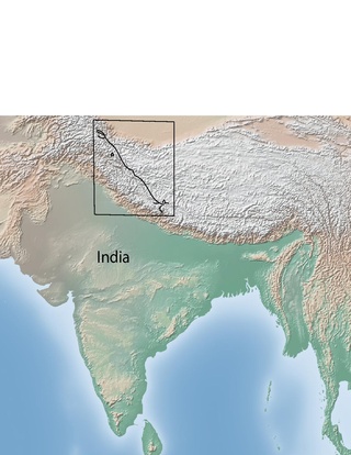
The Karakoram fault is an oblique-slip fault system in the Himalayan region across India and Asia. The slip along the fault accommodates radial expansion of the Himalayan arc, northward indentation of the Pamir Mountains, and eastward lateral extrusion of the Tibetan plateau. Current plate motions suggest that the convergence between the Indian Plate and the Eurasian Plate is around 44±5 mm per year in the western Himalaya-Pamir region and approximately 50±2 mm per year in the eastern Himalayan region.
The Ibagué Fault is a major dextral slightly oblique strike-slip fault in the department of Tolima in central Colombia. The fault has a total length of 123.9 kilometres (77.0 mi) and runs along an average east-northeast to west-southwest strike of 067.9 ± 11 cross-cutting the Central Ranges of the Colombian Andes.
The Totschunda Fault is a major active dextral (right-lateral) continental strike-slip fault in southeastern Alaska. It forms a link between the Denali Fault to the northwest and the Fairweather Fault to the southeast. The northwestern end of the fault ruptured during the 2002 Denali earthquake.

