
The Mid-Atlantic Ridge is a mid-ocean ridge located along the floor of the Atlantic Ocean, and part of the longest mountain range in the world. In the North Atlantic, the ridge separates the North American from the Eurasian plate and the African plate, north and south of the Azores triple junction. In the South Atlantic, it separates the African and South American plates. The ridge extends from a junction with the Gakkel Ridge northeast of Greenland southward to the Bouvet triple junction in the South Atlantic. Although the Mid-Atlantic Ridge is mostly an underwater feature, portions of it have enough elevation to extend above sea level, for example in Iceland. The ridge has an average spreading rate of about 2.5 centimetres (1 in) per year.

The Eurasian plate is a tectonic plate that includes most of Eurasia, with the notable exceptions of the Arabian Peninsula, the Indian subcontinent, and the area east of the Chersky Range in eastern Siberia. It also includes oceanic crust extending westward to the Mid-Atlantic Ridge and northward to the Gakkel Ridge.

The North American plate is a tectonic plate containing most of North America, Cuba, the Bahamas, extreme northeastern Asia, and parts of Iceland and the Azores. With an area of 76 million km2 (29 million sq mi), it is the Earth's second largest tectonic plate, behind the Pacific plate.
The East Pacific Rise (EPR) is a mid-ocean rise, at a divergent tectonic plate boundary, located along the floor of the Pacific Ocean. It separates the Pacific plate to the west from the North American plate, the Rivera plate, the Cocos plate, the Nazca plate, and the Antarctic plate. It runs south from the Gulf of California in the Salton Sea basin in Southern California to a point near 55°S130°W, where it joins the Pacific-Antarctic Ridge (PAR) trending west-south-west towards Antarctica, near New Zealand. Much of the rise lies about 3,200 km (2,000 mi) off the South American coast and reaches a height about 1,800–2,700 m (5,900–8,900 ft) above the surrounding seafloor.

A triple junction is the point where the boundaries of three tectonic plates meet. At the triple junction each of the three boundaries will be one of three types – a ridge (R), trench (T) or transform fault (F) – and triple junctions can be described according to the types of plate margin that meet at them. Of the ten possible types of triple junctions only a few are stable through time. The meeting of four or more plates is also theoretically possible, but junctions will only exist instantaneously.
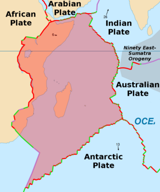
The Somali plate is a minor tectonic plate which straddles the Equator in the Eastern Hemisphere. It is currently in the process of separating from the African plate along the East African Rift Valley. It is approximately centered on the island of Madagascar and includes about half of the east coast of Africa, from the Gulf of Aden in the north through the East African Rift Valley. The southern boundary with the Nubian–African plate is a diffuse plate boundary consisting of the Lwandle plate.

Carlsberg Foundation is a not-for-profit organization that was founded by J. C. Jacobsen in 1876, by allocating some of his shares in the Carlsberg Brewery to fund and operate the Carlsberg Laboratory and the Museum of National History at Frederiksborg Palace. The foundation has since expanded to fund scientific research, and via the Tuborg Foundation to fund social works. As of 2011 it owned 30.3% of the shares in Carlsberg Group and controlled 74.2% of the voting power.

The following outline is provided as an overview of and introduction to Oceanography.
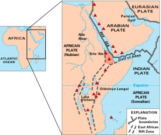
The Afar Triple Junction is located along a divergent plate boundary dividing the Nubian, Somali, and Arabian plates. This area is considered a present-day example of continental rifting leading to seafloor spreading and producing an oceanic basin. Here, the Red Sea Rift meets the Aden Ridge and the East African Rift. The latter extends a total of 6,500 kilometers (4,000 mi) from the Afar Triangle to Mozambique.
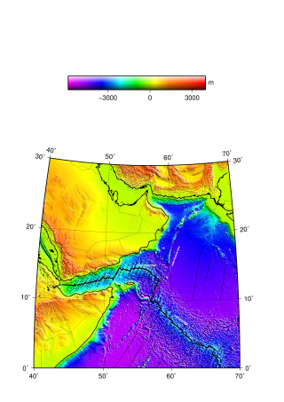
The Aden Ridge is a part of an active oblique rift system located in the Gulf of Aden, between Somalia and the Arabian Peninsula to the north. The rift system marks the divergent boundary between the Somali and Arabian tectonic plates, extending from the Owen Transform Fault in the Arabian Sea to the Afar triple junction or Afar Plume beneath the Gulf of Tadjoura in Djibouti.

The Owen fracture zone (OFZ), though misnamed as a fracture zone, is a transform fault in the northwest Indian Ocean that separates the Arabian and African plates from the Indian plate. Extending north-northeast from where the Carlsberg Ridge meets the Sheba ridge in the south to the Makran Subduction Zone in the north, it represents the port side of the northward motion of the Indian subcontinent during the Late Cretaceous–Palaeogene break-up of Gondwana. Slip along the Owen Fracture Zone is occurring at 2 mm (0.079 in)/yr, the slowest rate on Earth, which means the Arabian plate moves northward faster than the Indian plate.
The Aden–Owen–Carlsberg triple junction (AOC), also known as the Arabia–India–Somalia triple junction, is a triple junction that connects the Aden Ridge, Owen Fracture Zone, and Carlsberg Ridge in the northwest Indian Ocean. It has been described as one of only three RRF (ridge–ridge–fault) triple junctions on Earth, besides the Azores triple junction and Chile triple junction. However, because the fault arm of such unstable triple junctions tend to evolve into a spreading centre, all three cases have quickly evolved into stable RRR triple junctions.

The Central Indian Ridge (CIR) is a north–south-trending mid-ocean ridge in the western Indian Ocean.

The Rodrigues triple junction (RTJ), also known as the central Indian [Ocean] triple junction (CITJ) is a geologic triple junction in the southern Indian Ocean where three tectonic plates meet: the African plate, the Indo-Australian plate, and the Antarctic plate. The triple junction is named for the island of Rodrigues which lies 1,000 km (620 mi) north-west of it.

The Southwest Indian Ridge (SWIR) is a mid-ocean ridge located along the floors of the south-west Indian Ocean and south-east Atlantic Ocean. A divergent tectonic plate boundary separating the Somali plate to the north from the Antarctic plate to the south, the SWIR is characterised by ultra-slow spreading rates (only exceeding those of the Gakkel Ridge in the Arctic) combined with a fast lengthening of its axis between the two flanking triple junctions, Rodrigues (20°30′S70°00′E) in the Indian Ocean and Bouvet (54°17′S1°5′W) in the Atlantic Ocean.

The South American–Antarctic Ridge or simply American-Antarctic Ridge is the tectonic spreading center between the South American plate and the Antarctic plate. It runs along the sea-floor from the Bouvet triple junction in the South Atlantic Ocean south-westward to a major transform fault boundary east of the South Sandwich Islands. Near the Bouvet triple junction the spreading half rate is 9 mm/a (0.35 in/year), which is slow, and the SAAR has the rough topography characteristic of slow-spreading ridges.

The Macquarie triple junction is a geologically active tectonic boundary located at 61°30′S161°0′E at which the historic Indo-Australian plate, Pacific plate, and Antarctic plate collide and interact. The term triple junction is given to particular tectonic boundaries at which three separate tectonic plates meet at a specific, singular location. The Macquarie triple junction is located on the seafloor of the southern region of the Pacific Ocean, just south of New Zealand. This tectonic boundary was named in respect to the nearby Macquarie Island, which is located southeast of New Zealand.
This is a list of articles related to plate tectonics and tectonic plates.

The Lau Basin is a back-arc basin at the Australian-Pacific plate boundary. It is formed by the Pacific Plate subducting under the Australian Plate. The Tonga-Kermadec Ridge, a frontal arc, and the Lau-Colville Ridge, a remnant arc, sit to the eastern and western sides of the basin, respectively. The basin has a raised transition area to the south where it joins the Havre Trough.

A triple divide or triple watershed is a point on Earth's surface where three drainage basins meet. A triple divide results from the intersection of two drainage divides. Triple divides range from prominent mountain peaks to minor side peaks, down to simple slope changes on a ridge which are otherwise unremarkable. The elevation of a triple divide can be thousands of meters to barely above sea level. Triple divides are a common hydrographic feature of any terrain that has rivers, streams and/or lakes.

