The Alps form part of a Cenozoic orogenic belt of mountain chains, called the Alpide belt, that stretches through southern Europe and Asia from the Atlantic all the way to the Himalayas. This belt of mountain chains was formed during the Alpine orogeny. A gap in these mountain chains in central Europe separates the Alps from the Carpathians to the east. Orogeny took place continuously and tectonic subsidence has produced the gaps in between.
Obduction is a geological process whereby denser oceanic crust is scraped off a descending ocean plate at a convergent plate boundary and thrust on top of an adjacent plate. When oceanic and continental plates converge, normally the denser oceanic crust sinks under the continental crust in the process of subduction. Obduction, which is less common, normally occurs in plate collisions at orogenic belts or back-arc basins.

A convergent boundary is an area on Earth where two or more lithospheric plates collide. One plate eventually slides beneath the other, a process known as subduction. The subduction zone can be defined by a plane where many earthquakes occur, called the Wadati–Benioff zone. These collisions happen on scales of millions to tens of millions of years and can lead to volcanism, earthquakes, orogenesis, destruction of lithosphere, and deformation. Convergent boundaries occur between oceanic-oceanic lithosphere, oceanic-continental lithosphere, and continental-continental lithosphere. The geologic features related to convergent boundaries vary depending on crust types.

The African Plate, also known as the Nubian Plate, is a major tectonic plate that includes much of the continent of Africa and the adjacent oceanic crust to the west and south. It is bounded by the North American Plate and South American Plate to the west ; the Arabian Plate and Somali Plate to the east; the Eurasian Plate, Aegean Sea Plate and Anatolian Plate to the north; and the Antarctic Plate to the south.

The Periadriatic Seam is a distinct geologic fault in Southern Europe, running S-shaped about 1,000 km (621 mi) from the Tyrrhenian Sea through the whole Southern Alps as far as Hungary. It forms the division between the Adriatic Plate and the Eurasian Plate.

The Southern Alps are a geological subdivision of Alps that are found south of the Periadriatic Seam, a major geological faultzone across the Alps. The southern Alps contain almost the same area as the Southern Limestone Alps. The rocks of the southern Alps gradually go over in the Dinarides or Dinaric Alps to the south-east. In the south-west they disappear below recent sediments of the Po basin that are lying discordant on top of them.

The Valais Ocean is a subducted oceanic basin which was situated between the continent Europe and the microcontinent Iberia or so called Briançonnais microcontinent. Remnants of the Valais ocean are found in the western Alps and in tectonic windows of the eastern Alps and are mapped as the so-called "north Penninic" nappes.

The Piemont-Liguria basin or the Piemont-Liguria Ocean was a former piece of oceanic crust that is seen as part of the Tethys Ocean. Together with some other oceanic basins that existed between the continents Europe and Africa, the Piemont-Liguria Ocean is called the Western or Alpine Tethys Ocean.

A foreland basin is a structural basin that develops adjacent and parallel to a mountain belt. Foreland basins form because the immense mass created by crustal thickening associated with the evolution of a mountain belt causes the lithosphere to bend, by a process known as lithospheric flexure. The width and depth of the foreland basin is determined by the flexural rigidity of the underlying lithosphere, and the characteristics of the mountain belt. The foreland basin receives sediment that is eroded off the adjacent mountain belt, filling with thick sedimentary successions that thin away from the mountain belt. Foreland basins represent an endmember basin type, the other being rift basins. Space for sediments is provided by loading and downflexure to form foreland basins, in contrast to rift basins, where accommodation space is generated by lithospheric extension.

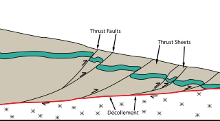
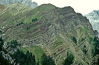
Thrust tectonics or contractional tectonics is concerned with the structures formed by, and the tectonic processes associated with, the shortening and thickening of the crust or lithosphere. It is one of the three main types of tectonic regime, the others being extensional tectonics and strike-slip tectonics. These match the three types of plate boundary, convergent (thrust), divergent (extensional) and transform (strike-slip). There are two main types of thrust tectonics, thin-skinned and thick-skinned, depending on whether or not basement rocks are involved in the deformation. The principle geological environments where thrust tectonics is observed are zones of continental collision, restraining bends on strike-slip faults and as part of detached fault systems on some passive margins.

The South Aegean Volcanic Arc is a volcanic arc in the South Aegean Sea formed by plate tectonics. The prior cause was the subduction of the African Plate beneath the Eurasian Plate, raising the Aegean arc across what is now the North Aegean Sea. It was not yet the sea, nor an arc, or at least not the one it is today, nor was there a chain of volcanoes. In the Holocene, the process of back-arc extension began, probably stimulated by pressure from the Arabian Plate compressing the region behind the arc. The extension deformed the region into its current configuration. First, the arc moved to the south and assumed its arcuate configuration. Second, the Aegean Sea opened behind the arc because the crust was thinned and weakened there. Third, magma broke through the thinned crust to form a second arc composed of a volcanic chain. And finally, the Aegean Sea Plate broke away from Eurasia in the new fault zone to the north.
This is a list of articles related to plate tectonics and tectonic plates.
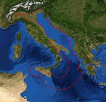
The geology of Sicily records the collision of the Eurasian and the African plates during westward-dipping subduction of the African slab since late Oligocene. Major tectonic units are the Hyblean foreland, the Gela foredeep, the Apenninic-Maghrebian orogen, and the Calabrian Arc. The orogen represents a fold-thrust belt that folds Mesozoic carbonates, while a major volcanic unit is found in an eastern portion of the island. The collision of Africa and Eurasia is a retreating subduction system, such that the descending Africa is falling away from Eurasia, and Eurasia extends and fills the space as the African plate falls into the mantle, resulting in volcanic activity in Sicily and the formation of Tyrrhenian slab to the north.
The geology of Austria consists of Precambrian rocks and minerals together with younger marine sedimentary rocks uplifted by the Alpine orogeny.

The geology of Croatia has some Precambrian rocks mostly covered by younger sedimentary rocks and deformed or superimposed by tectonic activity.

The geology of Italy includes mountain ranges such as the Alps and the Apennines formed from the uplift of igneous and primarily marine sedimentary rocks all formed since the Paleozoic. Some active volcanoes are located in Insular Italy.
The 1706 Abruzzo earthquake, also known as the Maiella earthquake, occurred on November 3 at 13:00 CEST. The earthquake with a possible epicenter in the Central Apennine Mountains (Maiella), Abruzzo had an estimated moment magnitude of 6.6–6.84 Mw . It was assigned a maximum Mercalli intensity of XI (Extreme), causing tremendous destruction in Valle Peligna. At least 2,400 people were killed.
The 1743 Salento earthquake affected the Apulian region of southwestern Italy on 20 February at 23:30 IST. The ~7.1 Mw earthquake had an epicenter in the Adriatic and Ionian seas, off the coast of modern-day Lecce and Brindisi provinces in Salento. It had a maximum Modified Mercalli intensity of IX (Violent), causing heavy damage in Nardò. Damage was also reported across the sea, in the Balkans. The earthquake also generated a tsunami of up to 11 meters in run-up. Between 180 and 300 people were killed in the disaster.


