You can help expand this article with text translated from the corresponding article in Norwegian. (August 2011)Click [show] for important translation instructions.
View a machine-translated version of the Norwegian article.
Machine translation, like DeepL or Google Translate, is a useful starting point for translations, but translators must revise errors as necessary and confirm that the translation is accurate, rather than simply copy-pasting machine-translated text into the English Wikipedia.
Do not translate text that appears unreliable or low-quality. If possible, verify the text with references provided in the foreign-language article.
You must provide copyright attribution in the edit summary accompanying your translation by providing an interlanguage link to the source of your translation. A model attribution edit summary is Content in this edit is translated from the existing Norwegian Wikipedia article at [[:no:Norges geologi]]; see its history for attribution.
You may also add the template {{Translated|no|Norges geologi}} to the talk page.
The geology of Norway encompasses the history of Earth that can be interpreted by rock types found in Norway, and the associated sedimentological history of soils and rock types.
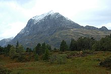
The Norwegian mountains were formed around 400 million years ago (Ma) during the Caledonian orogeny.
Precambrian
Rocks of Archean age in Norway are confined to a few 10km-scale areas within younger metamorphic belts exposed on islands off the west coast of northern Norway and as smaller fragments locally in the Western Gneiss region in south-central Norway.[1]
The later part of the Neoproterozoic records the break-up of the Rodiniasupercontinent and the formation of the Iapetus Ocean. Passive margin sequences are preserved within the lowermost allochthon and parautochthon of the Caledonian thrust sheets. In southern Norway the sequence is known as Sparagmite. The depositional environment changes from fluvial in the parautochthon to deepwater marine in the lowermost allochthon consistent with a paleogeography of an originally westward deepening basin.
The uppermost part of the Neoproterozoic sequence throughout Norway includes a tillite, a record of the Varanger ice age which occurred between roughly 630-590 Ma, the final part of the Cryogenian Period. This was followed by fluvial and shallow water marine deposits of the Ediacaran before a major marine transgression at the start of the Cambrian.
The early Palaeozoic history of Norway is recorded in sequences preserved either as autochthon or at various levels within the allochthon. They relate to the further widening of Iapetus during the Cambrian, the start of closure during the Early Ordovician with the accretion of terranes and ophioliteobduction during the Late Ordovician and continent-continent collision at the end of the Silurian.
Caledonian orogeny
Within the entire exposed 1800 kilometre length of this orogenic belt the following sequence is recognised from the base upwards:
thrust sheets containing sediments with fossil assemblages indicating an origin on the margin of the Laurentian plate
This vertically stacked sequence thus represents the passive margins of Baltica and Laurentia and intervening island arcs and back-arc basins telescoped together and emplaced on top of the Baltic Shield, involving hundreds of kilometres of shortening.
Devonian age continental sediments are exposed in three main areas in and around mainland Norway; the Solund, Kvamshesten, Håsteinen and Hornelen basins along the west coast between Sognefjord and Nordfjord, on the islands of Smøla, Hitra and the western end of the Fosen Peninsula in Trøndelag and at Røragen near Røros close to the Swedish border. Further Devonian deposits are found on Svalbard.[1]
During the Devonian Period the thickened welt of crust formed by the Caledonian orogeny began to collapse. Some thrust surfaces show evidence of reactivation as low-angle extensional faults, but the main structures formed at this time were large-scale extensional detachments. Movement on these detachments led to deposition of thick sequences of continental clastic sediments in their hanging walls and was in part responsible for the exhumation of late Caledonian ultra high-pressure metamorphic rocks, including eclogites, in their footwalls. The displacements on these structures range from nearly orthogonal to the Caledonian chain in the south to being strongly oblique in mid-Norway.
Carboniferous
The only Carboniferous age strata preserved onshore are found on Svalbard. Rocks of this age have also been proved by drilling beneath the Barents Sea, but nowhere else on the Norwegian continental shelf.
Permian
In southern Norway the Permian was a period of W-E directed rifting with associated igneous activity, during which the Oslo graben formed.
Triassic
The only Triassic rocks preserved onshore are found on Svalbard but strata of this age are also widely known from the results of exploration drilling along the entire continental shelf.
Jurassic
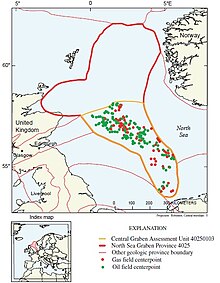
North Sea Central GrabenNorth Sea Viking Graben
Rocks of Jurassic age are exposed onshore at one locality on Andøya and have been discovered nearshore and beneath the Beitstadfjorden, northeast of Trondheim. As with the Triassic, Jurassic strata have a wide distribution along the whole continental shelf. They were dominantly deposited in a deltaic to shallow marine environment.
The Late Jurassic was the main rifting phase in the Central Graben, Viking Graben, More Basin, Vøring Basin and on the Barents shelf. This was also the period of deposition of the main source rock that has generated most of the petroleum discovered in the offshore areas.
Cretaceous
The Late Jurassic basins offshore were infilled and onlapped by the Cretaceous post-rift sequence. These are dominated by mudstones although the Upper Cretaceous sequence from the Viking Graben and south is dominated by chalk.
In the outer parts of the Vøring margin rifting restarted in the late Cretaceous, continuing through to the early Palaeocene. This event is interpreted to be a precursor to the break-up of the North Atlantic. Little is known of the then elevation of what would be the area of current day Norway.
↑ Hageskov, Bjørn; Pedersen, Svend (1988). "Rb-Sr age determination of the Kattsund-Koster dyke swarm in the Østfold-Marstrand belt of the Sveconorwegian Province, W Sweden - SE Norway". Bulletin of the Geological Society of Denmark. 37: 51–61.
Ramberg, I.B., Bryhni, I, & Nøttvedt, A. (ed.) (2007). Landet blir til (Norges geologi). Trondheim, Norsk Geologisk Forening. ISBN82-92394-31-1
This page is based on this Wikipedia article Text is available under the CC BY-SA 4.0 license; additional terms may apply. Images, videos and audio are available under their respective licenses.