Geology of the Netherlands

Last updated

The geology of the Netherlands describes the geological sequence of the Netherlands. Large parts of the Netherlands today are below sea level and have in the past been covered by the sea or flooded at regular intervals. The modern Netherlands formed as a result of the interplay of the four main rivers (Rhine, Meuse, Schelde and IJssel) and the influence of the North Sea and glaciers during ice-ages. The Netherlands is mostly composed of deltaic, coastal and eolian derived sediments during the Pleistocene glacial and interglacial periods.

Contents

Fairly all of the west Netherlands is composed of the Rhine-Meuse river estuary, but human intervention greatly modified the natural processes at work. Most of the western Netherlands is below sea level due to the human watermanagement, lowering the waterlevel by windmills leading to (mostly peaty) soil-subsidence leading to lowering the waterlevel.[ dubious ]

In the east of the Netherlands, remains are found of the Saale glaciation, which ended approximately 130,000 years ago. As the continental ice sheet moved in from the north, it pushed moraine forward. The ice sheet halted as it covered the eastern half of the Netherlands. After the ice age ended, the moraine remained in the form a long hill-line. The cities of Arnhem and Nijmegen are built upon these hills.
Sedimentary succession

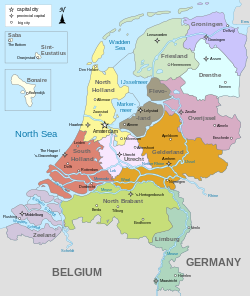
Map of the Netherlands Map provinces Netherlands-en.svg
Map of the Netherlands

Paleozoic Era

Rocks from the Carboniferous period (360 - 299 mya) outcrop in the southeastern province of Limburg, e.g. in the Heimans quarry. Younger sediments (Permian in age) are not exposed at surface. The subsurface of the Netherlands (including the Dutch sectors of the North Sea) is geologically far more significant especially with respect to the occurrence of oil and gas resources. The Slochteren reservoir rock in Groningen is an eolian sandstone from the Rotliegend (lower Permian). This reservoir has excellent porosity and permeability characteristics and supplies the vast majority of the Dutch natural gas reserves. The lateral equivalent of this reservoir comes at surface near the German town of Bad Bentheim.

The latest Permian deposits in the area of northwestern Europe was characterised by the laying down of thick successions of rocksalt and anhydrite. This Zechstein stage also comprises dolomites and limestones. The salt is mined in the east of the Netherlands (in villages as Boekelo) and forms an excellent seal over the deeper North Sea reservoirs.

Mesozoic Era

Mesozoic rocks are exposed in the Netherlands in the quarry near Winterswijk (Triassic Muschelkalk limestones). The Jurassic Posidonia Shale is well developed but is buried deep in the West and under the North Sea. It acts as source rock for oil fields in the West Netherlands Basin. During late Jurassic times the Zuidwal volcano was active in a now submerged part of the Netherlands known as the Wadden Sea.

During Cretaceous times, most of the Netherlands was covered by a warm shallow (inland) sea in which thick successions of chalk were deposited. This is in places chert-bearing; chalk is mined near the southern city of Maastricht and the Maastrichtian stage was named after this locality. Here a number of mosasaur-fossils have been excavated as well. The Schoonebeek oil-bearing sandstones are Early Cretaceous in age and underlain by hydrocarbon-rich Lower Cretaceous lacustrine Coevorden Formation which forms the source rock for the east Netherlands oil.

Cenozoic Era

The Cenozoic is characterised by a further shallowing and erosion of earlier sediments. In places a reasonable thickness of Paleocene and Eocene sediments is reached, but most of the subsurface of the Netherlands lack deposits of this age.

The recent Netherlands is formed by Pleistocene and Holocene age sediments as result of (glacio)-fluvial, eolian and marine sedimentation. Eolian dunes characterise the North Sea coast, a horseshoe-shaped moraine forms the Utrecht Hill Ridge (Dutch: Utrechtse Heuvelrug) and the river influence is still visible all over the Netherlands.

Tectonics and orogeny

Although the Netherlands seems to be a tectonically quiet area, a number of fault activities have been shown in the past. The latest strong earthquake, the 1992 Roermond earthquake (5.4 on Richter scale), had its epicenter close to the Limburg city of Roermond. The south of the Netherlands is topographically higher and is linked to the geology of the Ardennes and the London-Brabant Massif. The Lower Rhine Graben, part of the European Cenozoic Rift System, which has been tectonically active since the Oligocene, affects the southwestern part of the Netherlands.

See also

Related Research Articles

<span class="mw-page-title-main">Geology of the Alps</span> The formation and structure of the European Alps

The Alps form part of a Cenozoic orogenic belt of mountain chains, called the Alpide belt, that stretches through southern Europe and Asia from the Atlantic all the way to the Himalayas. This belt of mountain chains was formed during the Alpine orogeny. A gap in these mountain chains in central Europe separates the Alps from the Carpathians to the east. Orogeny took place continuously and tectonic subsidence has produced the gaps in between.

<span class="mw-page-title-main">Salt dome</span> Structural dome formed of salt or halite

A salt dome is a type of structural dome formed when salt intrudes into overlying rocks in a process known as diapirism. Salt domes can have unique surface and subsurface structures, and they can be discovered using techniques such as seismic reflection. They are important in petroleum geology as they can function as petroleum traps.

The Perth Basin is a thick, elongated sedimentary basin in Western Australia. It lies beneath the Swan Coastal Plain west of the Darling Scarp, representing the western limit of the much older Yilgarn Craton, and extends further west offshore. Cities and towns including Perth, Busselton, Bunbury, Mandurah and Geraldton are built over the Perth Basin.

<span class="mw-page-title-main">Geology of Texas</span> Overview of the geology of the U.S. state of Texas

Texas contains a wide variety of geologic settings. The state's stratigraphy has been largely influenced by marine transgressive-regressive cycles during the Phanerozoic, with a lesser but still significant contribution from late Cenozoic tectonic activity, as well as the remnants of a Paleozoic mountain range.

<span class="mw-page-title-main">San Juan Basin</span>

The San Juan Basin is a geologic structural basin located near the Four Corners region of the Southwestern United States. The basin covers 7,500 square miles and resides in northwestern New Mexico, southwestern Colorado, and parts of Utah and Arizona. Specifically, the basin occupies space in the San Juan, Rio Arriba, Sandoval, and McKinley counties in New Mexico, and La Plata and Archuleta counties in Colorado. The basin extends roughly 100 miles (160 km) N-S and 90 miles (140 km) E-W.

<span class="mw-page-title-main">Geology of England</span> Overview of the geology of England

The geology of England is mainly sedimentary. The youngest rocks are in the south east around London, progressing in age in a north westerly direction. The Tees–Exe line marks the division between younger, softer and low-lying rocks in the south east and the generally older and harder rocks of the north and west which give rise to higher relief in those regions. The geology of England is recognisable in the landscape of its counties, the building materials of its towns and its regional extractive industries.

<span class="mw-page-title-main">Geology of Bangladesh</span>

The Geology of Bangladesh is affected by the country's location, as Bangladesh is mainly a riverine country. It is the eastern two-thirds of the Ganges and Brahmaputra river delta plain stretching to the north from the Bay of Bengal. There are two small areas of slightly higher land in the north-centre and north-west composed of old alluvium called the Madhupur Tract and the Barind Tract, and steep, folded, hill ranges of older (Tertiary) rocks along the eastern border.

<span class="mw-page-title-main">Geology of Kansas</span>

The geology of Kansas encompasses the geologic history and the presently exposed rock and soil. Rock that crops out in the US state of Kansas was formed during the Phanerozoic eon, which consists of three geologic eras: the Paleozoic, Mesozoic and Cenozoic. Paleozoic rocks at the surface in Kansas are primarily from the Mississippian, Pennsylvanian, and Permian periods.

<span class="mw-page-title-main">Geology of the North Sea</span> Description of the current geological features and the geological history that created them

The geology of the North Sea describes the geological features such as channels, trenches, and ridges today and the geological history, plate tectonics, and geological events that created them.

The Rotliegend, Rotliegend Group or Rotliegendes is a lithostratigraphic unit of latest Carboniferous to Guadalupian age that is found in the subsurface of large areas in western and central Europe. The Rotliegend mainly consists of sandstone layers. It is usually covered by the Zechstein and lies on top of regionally different formations of late Carboniferous age.

<span class="mw-page-title-main">Geology of the southern North Sea</span> Largest gas producing basin

The North Sea basin is located in northern Europe and lies between the United Kingdom, and Norway just north of The Netherlands and can be divided into many sub-basins. The Southern North Sea basin is the largest gas producing basin in the UK continental shelf, with production coming from the lower Permian sandstones which are sealed by the upper Zechstein salt. The evolution of the North Sea basin occurred through multiple stages throughout the geologic timeline. First the creation of the Sub-Cambrian peneplain, followed by the Caledonian Orogeny in the late Silurian and early Devonian. Rift phases occurred in the late Paleozoic and early Mesozoic which allowed the opening of the northeastern Atlantic. Differential uplift occurred in the late Paleogene and Neogene. The geology of the Southern North Sea basin has a complex history of basinal subsidence that had occurred in the Paleozoic, Mesozoic, and Cenozoic. Uplift events occurred which were then followed by crustal extension which allowed rocks to become folded and faulted late in the Paleozoic. Tectonic movements allowed for halokinesis to occur with more uplift in the Mesozoic followed by a major phase of inversion occurred in the Cenozoic affecting many basins in northwestern Europe. The overall saucer-shaped geometry of the southern North Sea Basin indicates that the major faults have not been actively controlling sediment distribution.

<span class="mw-page-title-main">North German basin</span> Passive-active rift basin in central and west Europe

The North German Basin is a passive-active rift basin located in central and west Europe, lying within the southeasternmost portions of the North Sea and the southwestern Baltic Sea and across terrestrial portions of northern Germany, Netherlands, and Poland. The North German Basin is a sub-basin of the Southern Permian Basin, that accounts for a composite of intra-continental basins composed of Permian to Cenozoic sediments, which have accumulated to thicknesses around 10–12 kilometres (6–7.5 mi). The complex evolution of the basin takes place from the Permian to the Cenozoic, and is largely influenced by multiple stages of rifting, subsidence, and salt tectonic events. The North German Basin also accounts for a significant amount of Western Europe's natural gas resources, including one of the world's largest natural gas reservoir, the Groningen gas field.

The geology of the Baltic Sea is characterized by having areas located both at the Baltic Shield of the East European Craton and in the Danish-North German-Polish Caledonides. Historical geologists make a distinction between the current Baltic Sea depression, formed in the Cenozoic era, and the much older sedimentary basins whose sediments are preserved in the zone. Although glacial erosion has contributed to shape the present depression, the Baltic trough is largely a depression of tectonic origin that existed long before the Quaternary glaciation.

<span class="mw-page-title-main">Geology of Germany</span> Overview of the geology of Germany

The geology of Germany is heavily influenced by several phases of orogeny in the Paleozoic and the Cenozoic, by sedimentation in shelf seas and epicontinental seas and on plains in the Permian and Mesozoic as well as by the Quaternary glaciations.

The geology of Belgium encompasses rocks, minerals and tectonic events stretching back more than 500 million years. Belgium covers an area of about 30,507 square kilometers and was instrumental in the development of geology. The extensive outcrops in Belgium became the standard reference points in stratigraphy as early as the mid-19th century. Some of them are internationally recognized features related to the Carboniferous and the Devonian periods. These rocks were folded by two orogeny mountain building events --the Hercynian orogeny, and Caledonian Orogeny. Paleozoic basement rocks cover much of the country and are overlain by Mesozoic and Cenozoic sediments.

The geology of Afghanistan includes nearly one billion year old rocks from the Precambrian. The region experienced widespread marine transgressions and deposition during the Paleozoic and Mesozoic, that continued into the Cenozoic with the uplift of the Hindu Kush mountains.

The geology of Thailand includes deep crystalline metamorphic basement rocks, overlain by extensive sandstone, limestone, turbidites and some volcanic rocks. The region experienced complicated tectonics during the Paleozoic, long-running shallow water conditions and then renewed uplift and erosion in the past several million years ago.

<span class="mw-page-title-main">Geology of Slovakia</span> Overview of the geology of Slovakia

The geology of Slovakia is structurally complex, with a highly varied array of mountain ranges and belts largely formed during the Paleozoic, Mesozoic and Cenozoic eras.

<span class="mw-page-title-main">Greater Green River Basin</span> River basin in southwestern Wyoming, United States

The Greater Green River Basin (GGRB) is a 21,000 square mile basin located in Southwestern Wyoming. The Basin was formed during the Cretaceous period sourced by underlying Permian and Cretaceous deposits. The GGRB is host to many anticlines created during the Laramide Orogeny trapping many of its hydrocarbon resources. It is bounded by the Rawlins Uplift, Uinta Mountains, Sevier overthrust belt, Sierra Madre Mountains, and the Wind River Mountain Range. The Greater Green River Basin is subdivided into four smaller basins, the Green River Basin, Great Divide Basin, Washakie Basin, and Sand Wash Basin. Each of these possesses hydrocarbons that have been economically exploited. There are 303 named fields throughout the basin, the majority of which produce natural gas; the largest of these gas fields is the Jonah Field.

<span class="mw-page-title-main">Alaska North Slope basin</span>

The Alaskan North Slope (ANS) is a foreland basin located on the northern edge of the Brooks Range. The Alaskan North Slope is bounded on the north by the Beaufort Sea and runs from the Canadian border to the maritime boundary with Russia in the west. The western edge extends into the Chukchi Sea and Chukchi platform where the basin is at its widest. As the basin moves east it narrows towards the Canadian border. The basin is 1000 km long, 600 km at its widest, and covers a total area of 240,000 km2.

References

Wong, Th.E.; Batjes, D.A.J. & Jager, J. de; 2007: Geology of the Netherlands, KNAW, ISBN   90-6984-481-8