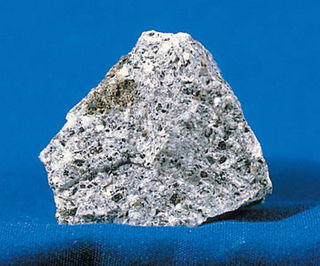
Syenite is a coarse-grained intrusive igneous rock with a general composition similar to that of granite, but deficient in quartz, which, if present at all, occurs in relatively small concentrations. Some syenites contain larger proportions of mafic components and smaller amounts of felsic material than most granites; those are classed as being of intermediate composition. The volcanic equivalent of syenite is trachyte.

Laurasia, was the more northern of two large landmasses that formed part of the Pangaea supercontinent from around 335 to 175 million years ago (Mya), the other being Gondwana. It separated from Gondwana 215 to 175 Mya during the breakup of Pangaea, drifting farther north after the split and finally broke apart with the opening of the North Atlantic Ocean c. 56 Mya. The name is a blend of Laurentia and Asia.
An aulacogen is a failed arm of a triple junction. Aulacogens are a part of plate tectonics where oceanic and continental crust is continuously being created, destroyed, and rearranged on the Earth’s surface. Specifically, aulacogens are a rift zone, where new crust is formed, that is no longer active.
Kenorland was one of the earliest known supercontinents on Earth. It is thought to have formed during the Neoarchaean Era c. 2.72 billion years ago (2.72Ga) by the accretion of Neoarchaean cratons and the formation of new continental crust. It comprised what later became Laurentia, Baltica, Western Australia and Kalaharia.
The Late Devonian extinction refers to one or more extinction events in the Late Devonian Epoch, which collectively represent one of five largest mass extinction events in the history of life on Earth. The term primarily refers to a major extinction, the Kellwasser event, which occurred around 372 million years ago, at the boundary between the Frasnian stage and the Famennian stage, the last stage in the Devonian Period. Overall, 19% of all families and 50% of all genera became extinct. A second, distinct mass extinction, the Hangenberg event, occurred 359 million years ago, bringing an end to the Famennian and Devonian, as the world transitioned into the Carboniferous Period.

Carbonatite is a type of intrusive or extrusive igneous rock defined by mineralogic composition consisting of greater than 50% carbonate minerals. Carbonatites may be confused with marble and may require geochemical verification.

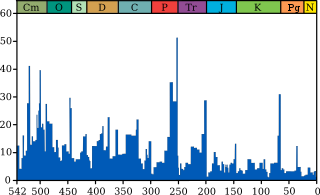
A large igneous province (LIP) is an extremely large accumulation of igneous rocks, including intrusive and extrusive, arising when magma travels through the crust towards the surface. The formation of LIPs is variously attributed to mantle plumes or to processes associated with divergent plate tectonics. The formation of some of the LIPs in the past 500 million years coincide in time with mass extinctions and rapid climatic changes, which has led to numerous hypotheses about causal relationships. LIPs are fundamentally different from any other currently active volcanoes or volcanic systems.

The East African Rift (EAR) or East African Rift System (EARS) is an active continental rift zone in East Africa. The EAR began developing around the onset of the Miocene, 22–25 million years ago. In the past it was considered to be part of a larger Great Rift Valley that extended north to Asia Minor.

The Sarmatian Craton or Sarmatia is the southern segment/region of the East European Craton or Baltica, also known as Scythian Plateau. The craton contains Archaean rocks 2.8 to 3.7 billion years old (Ga). During the Carboniferous the craton was rifted apart by the Dnieper-Donets rift. As a result, geomorphologically the cratonic area is split by the Donbass Fold Belt, also known as a part of the large Pripyat-Dniepr-Donets aulacogen, which transects Sarmatia, dividing it into the Ukrainian Massif or shield on the southwest and the Voronezh Massif to the northeast.

The North China Craton is a continental crustal block with one of Earth's most complete and complex records of igneous, sedimentary and metamorphic processes. It is located in northeast China, Inner Mongolia, the Yellow Sea, and North Korea. The term craton designates this as a piece of continent that is stable, buoyant and rigid. Basic properties of the cratonic crust include being thick, relatively cold when compared to other regions, and low density. The North China Craton is an ancient craton, which experienced a long period of stability and fitted the definition of a craton well. However, the North China Craton later experienced destruction of some of its deeper parts (decratonization), which means that this piece of continent is no longer as stable.
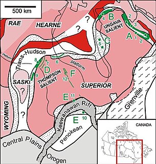
The Circum-Superior Belt is a widespread Paleoproterozoic large igneous province in the Canadian Shield of Northern, Western and Eastern Canada. It extends more than 3,400 km (2,100 mi) from northeastern Manitoba through northwestern Ontario, southern Nunavut to northern Quebec. Igneous rocks of the Circum-Superior Belt are mafic-ultramafic in composition, deposited in the Labrador Trough near Ungava Bay, the Cape Smith Belt near the southern shore of Hudson Strait and along the eastern shore of Hudson Bay in its northern portion; the Thompson and Fox River belts in the northwest and the Marquette Range Supergroup in its southern portion. The Circum Superior Belt also hosts a rare example of Proterozoic Komatiite, in the Winnipegosis komatiite belt.
The Erebus hotspot is a volcanic hotspot responsible for the high volcanic activity on Ross Island in the western Ross Sea of Antarctica. Its current eruptive zone, Mount Erebus, has erupted continuously since its discovery in 1841. Magmas of the Erebus hotspot are similar to those erupted from hotspots at the active East African Rift in eastern Africa. Mount Bird at the northernmost end of Ross Island and Mount Terror at its eastern end are large basaltic shield volcanoes that have been potassium-argon dated 3.8–4.8 and 0.8–1.8 million years old.

The Great Rift Valley is part of an intra-continental ridge system that runs through Kenya from north to south. It is part of the Gregory Rift, the eastern branch of the East African Rift, which starts in Tanzania to the south and continues northward into Ethiopia. It was formed on the "Kenyan Dome" a geographical upwelling created by the interactions of three major tectonics: the Arabian, Nubian, and Somalian plates. In the past, it was seen as part of a "Great Rift Valley" that ran from Madagascar to Syria. Most of the valley falls within the former Rift Valley Province.
East European Platform or Russian Platform is a large and flat area covered by sediments in Eastern Europe spanning from the Ural Mountains to the Tornquist Zone and from the Peri-Caspian Basin to the Barents Sea. Over geological time the platform area has experienced extension, inversion and compression. It has an area of about 6 million km2. The East European Platform sediments can be classified into the following groups: a "protoplatform" of metamorphosed sediments at the bottom, a "quasiplatform" of slightly deformed sediments, a "cataplatform", and a "orthoplatform" at the top. The Mesoproterozoic Jotnian sediments of the Baltic area are examples of a "quasiplatform". The oldest preserved continuous sedimentary cover in the platform date to the Vendian about 650 million years ago. The cycles of deposition of platform sediments are related to the development of nearby orogenies like the Timanide orogeny, the Uralian orogeny, the Hercynian orogeny and the Caledonian orogeny.

The geology of Finland is made up of a mix of geologically very young and very old materials. Common rock types are orthogneiss, granite, metavolcanics and metasedimentary rocks. On top of these lies is a widespread thin layer of unconsolidated deposits formed in connection to the Quaternary ice ages, for example eskers, till and marine clay. The topographic relief is rather subdued because mountain massifs were worn down to a peneplain long ago.

The Kola Alkaline Province or Kola Alkaline Carbonatite Province is a discontiguous group of unusual igneous rocks centered in the Kola Peninsula of Russia and with ouliers in nearby areas of Finland and in Arkhangelsk Oblast across the White Sea. The province is made up of alkaline-ultramafic rock complexes often associated to carbonatites and stand-alone dykes and pipes made up of carbonatites, kimberlites and similar rocks. To this it adds the large nepheline syenite bodies of the Lovozero Massif and the Khibiny Mountains. An estimate puts the total volume of the rocks of the Kola Alkaline Province at 15,000 ±2,700 km3.

Noronha hotspot is a hypothesized hotspot in the Atlantic Ocean. It has been proposed as the candidate source for volcanism in the Fernando de Noronha archipelago of Brazil, as well as of other volcanoes also in Brazil and even the Bahamas and the Central Atlantic Magmatic Province.
The geology of Ukraine is the regional study of rocks, minerals, tectonics, natural resources and groundwater in the country. The oldest rocks in the region are part of the Ukrainian Shield and formed more than 2.5 billion years ago in the Archean eon of the Precambrian. Extensive tectonic evolution and numerous orogeny mountain building events fractured the crust into numerous block, horsts, grabens and depressions and Ukraine was intermittently flooded as the crust downwarped during much of the Paleozoic, Mesozoic and early Cenozoic, before the formation of the Alps and Carpathians defined much of its current topography and tectonics. Ukraine was impacted by the Pleistocene glaciations within the last several hundred thousand years. The country has numerous metal deposits as well as minerals, building stone and high-quality industrial sands.

The plate theory is a model of volcanism that attributes all volcanic activity on Earth, even that which appears superficially to be anomalous, to the operation of plate tectonics. According to the plate theory, the principal cause of volcanism is extension of the lithosphere. Extension of the lithosphere is a function of the lithospheric stress field. The global distribution of volcanic activity at a given time reflects the contemporaneous lithospheric stress field, and changes in the spatial and temporal distribution of volcanoes reflect changes in the stress field. The main factors governing the evolution of the stress field are:
- Changes in the configuration of plate boundaries.
- Vertical motions.
- Thermal contraction.

