Cimmeria (continent)

Last updated
Tectonic history of Cimmeria
249 global.png
Cimmeria rifted off Gondwana's north-eastern shores around 250  Ma. [1]
230 Ma plate tectonic reconstruction.png
As Cimmeria migrated from Gondwana to Eurasia the Paleo-Tethys closed and the Neo-Tethys opened. [2]
100 global.png
After 150 million years Cimmeria collided with Eurasia and the Cimmerian orogeny closed the Paleo-Tethys. As the break-up of Gondwana began in the south, the opening of the Indian Ocean initiated the closure of the Neo-Tethys. [1]

Cimmeria was an ancient continent, or, rather, a string of microcontinents or terranes, [3] that rifted from Gondwana in the Southern Hemisphere and was accreted to Eurasia in the Northern Hemisphere. It consisted of parts of present-day Turkey, Iran, Afghanistan, Pakistan, Tibet, China, Myanmar, Thailand, and Malaysia. [4] [5] Cimmeria rifted from the Gondwanan shores of the Paleo-Tethys Ocean during the Early Permian [6] and as the Neo-Tethys Ocean opened behind it, during the Permian, the Paleo-Tethys closed in front of it. [7] Because the different chunks of Cimmeria drifted northward at different rates, a Meso-Tethys Ocean formed between the different fragments during the Cisuralian. [8] Cimmeria rifted off Gondwana from east to west, from Australia to the eastern Mediterranean. [9] It stretched across several latitudes and spanned a wide range of climatic zones. [10]

Contents

History of the concept

First concepts

A "large, ancient Mediterranean Sea" was first proposed by Austrian palaeontologist Melchior Neumayr in 1883. [11] Studying the distribution of Jurassic faunas, he concluded that an equatorial ocean stretching from India to Central America must have separated a large continent in the northern hemisphere from one in the southern hemisphere. Austrian geologist Eduard Suess named this Mesozoic ocean the Tethys, a mythical ocean which separated a mythical continent – Gondwanaland, home of the tongue-shaped flora  – from a boreal continent. [12] German geophysicist Alfred Wegener, in contrast, developed a concept of a single, global continent – the supercontinent Pangea  – which, in his view, left no room for an equatorial ocean. A wedge-shaped, east-facing Tethys within Pangea was, nevertheless, proposed by Australian geologist Samuel Warren Carey in 1958. [13] This ocean was later identified as a succession of oceans separated by north-migrating terranes or continental blocks, one of which was Cimmeria.

Iranian microcontinent

In 1974, after extensive field work in the Middle East, Swiss geologist Jovan Stöcklin identified the northern foot of the Alborz Range in northern Iran as the suture which in the Paleozoic was the northern shore of Gondwana and the remains of the Paleo-Tethys Ocean. Stöcklin also noted that an early Mesozoic or late Paleozoic rift separated the Iranian Plate from the Arabian Plate, and that another southern suture must be the remains of the Neo-Tethys Ocean. The opening of this later ocean, Stöcklin realized, must have transformed Iran into a microcontinent. Those observations made Stöcklin the first to identify a small part of what would later be known as Cimmeria. [14]

Stöcklin also noted that his proposal resembled the old concept of the world in which there were two continents, Angaraland in the north and Gondwana in the south, separated by an elongated ocean, the Tethys. Iran belonged to neither continent but was part of the realm of Tethys. [14] Stöcklin's southern suture was later confirmed by observations of the evolution of microflora in Iran, which had a Gondwanan affinity during the Carboniferous but a Eurasian affinity during the Late Triassic – Iran had clearly drifted from Gondwana to Laurasia. [15]

Eurasian superterrane

The Alpide belt is a system of sutures stretching across Eurasia within which the Cimmerian blocks are now located. Alpiner Gebirgsgurtel.png
The Alpide belt is a system of sutures stretching across Eurasia within which the Cimmerian blocks are now located.

In the 1980s Turkish geologist Celâl Şengör finally extended Stöcklin's Iranian microcontinent further west to Turkey and further east to Tibet and the Far East. [16] Şengör also reused the name introduced by Suess in 1901, the "Kimmerisches Gebirge" – the "Crimean" or "Cimmerian Mountains". [15] [17] [18]

In the mountain range that now stretches from the Alps to Indonesia Şengör identified, using a simplified scheme, two distinct but superimposed orogenic systems containing a large number of anastomosing sutures: the older Cimmerides and the younger Alpides together forming what Şengör called the Tethysides super-orogenic system. These two orogenic systems are thus associated with two major periods of ocean closure: the earlier, northern, and much larger Cimmerides, and the later, southern, and smaller Alpides. Cimmeria was the long continental "archipelago" that separated the two oceans before the Paleo-Tethys closed. [18]

This realm of Tethys thus covers most of Eurasia and a large time span (from north to south): [18]

This simple scheme, however, partly obscures the complex nature of the Tethyan cycles and terms such as "Eocimmerian" and "Neocimmerian" is often used for Late Triassic and Late Jurassic events respectively. [19] Furthermore, a distinction is often made between two more recent Tethyan domains: the Alpine Tethys and the Neo-Tethys. The Alpine Tethys, the western domain in this scheme, separated south-western Europe from north-western Africa and was connected to the Central Atlantic. It is now completely closed and its suture encompasses the Maghrebids (stretching from Gibraltar to Sicily) as well as the Apennines and the Alps. The Neo-Tethys, the eastern domain, opened between Arabia and the Cimmerian terranes. The East Mediterranean Basin and the Gulf of Oman are considered relics of the Neo-Tethys which is thus still closing. These two domains were connected east of Sicily until the end of the Jurassic. [20]

Tectonic history

In the Late Paleozoic, when the Cimmerian blocks were still located on the northern margin of Gondwana, they were far away from any active margins and orogenic belts, but they had been affected by thermal subsidence since the Siluran opening of Paleo-Tethys. Carboniferous to Permian ophiolites along suture zones in Tibet and north-eastern Iran indicate that the active margin of Paleo-Tethys was located here. [21] It was slab-pull forces in the Paleo-Tethys that detached Cimmeria from Gondwana and opened the Neo-Tethys. The mid-ocean ridge in the Paleo-Tethys subducted under Eurasia, as evidenced by Permian MORB (mid-ocean ridge basalt) in Iran. Slab roll-back in the Paleo-Tethys opened a series of back-arc basins along the Eurasian margin and resulted in the collapse of the Variscan cordillera. As the Paleo-Tethys subducted under the Eurasian southern margin, back-arc oceans formed from Austria to China. Some of these back-arcs closed during the Cimmerian orogeny (e.g. the Karakaya-Küre sequence of back-arc oceans in Turkey), others remained open (e.g. the Meliata-Maliac-Pindos back-arc oceans in the eastern Mediterranean) leading to the formation of younger back-arc oceans. [9]

Turkey

Geological map of Turkey Anatolian Plate Vectoral.svg
Geological map of Turkey

Turkey is an assemblage of continental blocks that during the Permian were part of the northern margin of Gondwana. During the Permian-Triassic, as the Paleo-Tethys subducted under this margin (in what is today northern Turkey) a marginal sea opened and quickly filled with sediments (today the basement of the Sakarya Composite Terrane in the Pontides). During the Late Triassic the Neo-Tethys began opening behind Cimmeria when the Eastern Mediterranean and its two eastern branches opened into the Bitlis-Zagros ocean (the southern branch of the Neo-Tethys). [22]

During Early Jurassic Cimmeria began to disintegrate behind the Paleo-Tethyan volcanic arc. This opened the northern branch in the Neo-Tethys — the Intra-Pontide, Izmh[ citation needed ]-Ankara, and the Inner Tauride oceans. The closure of the Paleo-Tethys in the Middle Jurassic reduced the Cimmerian archipelago in Anatolia. South of the Cimmerian blocks there were now two branches of the Neo-Tethys, a northern, larger and more complex, and a southern, more reduced; the Anatolide-Tauride continent separated them, the small Sakarya continent was located within the northern branch. The Apulian continent was connected to the Anatolide-Tauride continent. [22]

These Neo-Tethyan branches reached their maximum width during the Early Cretaceous, after which subduction under Eurasia gradually consumed them. During the Middle-Late Cretaceous this subduction opened a back-arc basin, the Western Black Sea Basin, which stretched west into the Balkans north of the Rhodope-Pontide island arc there. [23] In the Cretaceous, this basin pushed the Istanbul terrane (near today's Istanbul) southward in front of it, from the Odesa Shelf in the north-western Black Sea. In the Eocene, the terrane finally collided with Cimmeria thereby ending the extension in the western Black Sea. Contemporaneously, the East Black Sea Basin opened when the East Black Sea Block was rotated counter-clockwise towards Caucasus. [24]

In the late Cretaceous northwards intra-oceanic subduction within the Neotethys gave way to the obduction of ophiolitic nappes over the Arabian platform from Turkey to Oman region. North of this subduction zone, remnants of the Neotethys ocean started to subduct northwards and led to the collision of Tauride Block with the Arabian plate during post-Oligocene times. North of these systems, the Tauride block collided with the southern margin of Eurasia by the end of the Cretaceous. Convergence continued until the end of Oligocene. The Arabian-Eurasian collision in eastern Turkey during the Late Eocene closed the two basins. [22]

During the Paleogene Neo-Tethyan oceanic crust attached to the African Plate subducted along the Crete and Cyprus trenches. The Anatolide-Tauride continent collided with the Pontide and Kırşehir blocks in the Late Paleocene-Early Eocene. This closed the Ankara-Erzincan branches of the northern Neo-Tethys. During this closure, slab roll-back and break-off in the Eocene resulted in inversion in the Pontides and widespread magmatism in northern Turkey. Extension and upwelling followed, resulting in melting of lithospheric material beneath the Pontides. [25]

In southern Turkey the northward subduction of the Neo-tethys along the Bitlis-Zagros subduction zone resulted in magmatism in the Maden-Helete arc (south-eastern Turkey) during the Late Cretaceous-Eocene and back-arc magmatism in the Taurides. The Bitlis-Zagros subduction zone finally closed in the Miocene and throughout the Oligocene-Neogene and Quaternary volcanism became increasingly localised. In the Late Oligocene, slab roll-back in the Hellenic Trench resulted in extension in the Aegean and western Turkey. [25]

Iran

The subduction of western Neo-Tethys under Eurasia resulted in extensive magmatism in what is now northern Iran. In the Early Jurassic this magmatism had produced a slab pull force which contributed to the break-up of Pangea and the initial opening of the Atlantic. During the Late Jurassic-Early Cretaceous the subduction of the Neo-Tethys mid-ocean ridge contributed to the break-up of Gondwana, including the detachment of the Argo-Burma terrane from Australia. [9] The Central-East Iranian Microcontinent (CEIM) sutured with Eurasia in the Late Triassic during the regional "Eocimmerian" orogenic event in northern Iran, but Iran is made of several continental blocks and the area must have seen a number of ocean closures in the Late Paleozoic and Early Mesozoic. [26]

Caucasus

The Greater and Lesser Caucasus has a complicated geological history involving the accretion of a series of terranes and microcontinents from the Late Precambrian to the Jurassic within the Tethyan framework. These include the Greater Caucasian, Black Sea-Central Transcaucasian, Baiburt-Sevanian, and Iran-Afghanistan terranes and island arcs. [27] In the Caucasus region remnants of the Paleo-Tethys suture can be found in the Dzirula Massif which outcrops Early Jurassic sequences in central Georgia. It consists of Early Cambrian oceanic rocks and the possible remnants of a magmatic arc; their geometry suggests that suturing was followed by strike-slip faulting. Ophiolites also outcrop in the Khrami Massif in southern Georgia and another possible segment of the suture is present in the Svanetia region. The suture is older east of the Caucasus (northern Iran–Turkmenistan) but younger both west of the Caucasus and further east in Afghanistan and the northern Pamirs. [28]

Sibumasu

The easternmost part of Cimmeria, the Sibumasu terrane, remained attached to north-western Australia until 295–290 Ma when it began to drift northward, as supported by paleomagnetic and biogeographic data. The Qiangtang terrane was located west of Sibumasu and contiguous with it. Lower Permian layers in Sibumasu contain glacial-marine diamictites and Gondwanan faunas and floras which then developed independently before Sibumasu docked with Cathaysia. Sibumasu's rapid northern journey is especially evident in the development of brachiopods and fusulinids. [29]

The Baoshan terrane in western Yunnan, China, forms the northern part of Sibumasu. It is separated from the Burma Block by the Gaoligong Suture Zone to the west, and from the South China and Indochina continents in the east by the Chongshan Suture Zone and Changning-Menglian Belt. Like other parts of eastern Cimmeria, it was highly deformed by the intra-continental strike-slip faulting that followed the India-Asia collision. [30]

Paleomagnetic data indicate South China and Indochina moved from near Equator to 20°N from the Early Permian to Late Triassic. Baoshan, in contrast, moved from 42°S in the Early Permian to 15°N in the Late Triassic. These blocks and terranes occupied similar paleo-latitudes during Late Triassic to Jurassic which indicates that they probably collided in the Late Triassic. This is also supported by geological evidence: 200–230 Ma granite in Lincang, near the Changning-Menglian suture, indicate a continent-continent collision occurred there in the Late Triassic; pelagic sediments in the Changning-Menglian-Inthanon ophiolite belt (between Sibumasu and Indochina) ranges in age from Middle Devonian to Middle Triassic, while, in the Inthanon suture, in contrast, Middle to Late Triassic rocks are non-pelagic with radiolarian cherts and turbidic clastics indicating the two blocks had at least approached each other by that time; volcanic sequences from the Lancangjiang igneous zone indicate a post-collisional setting had developed before the eruptions there around 210 Ma; and, the Sibumasu fauna developed from a non-marine peri-Gondwanan assemblage in the early Permian, to an endemic Sibumasu fauna in the Middle Permian, and to an Equatorial-Cathaysian in the Late Permian. [31]

During the Early and Middle Palaeozoic Cimmeria was located at an Andean-style active margin. Glacial deposits and paleomagnetic data indicate that Qiangtang and Shan Thai-Malaya were still located far south adjacent to Gondwana during the Carboniferous. The equatorial fauna and flora of China indicate that it was separated from Gondwana during the Carboniferous. [4]

Lhasa

The Lhasa terrane has been interpreted as part of Cimmeria and, if this is the case, must have rifted from Gondwana together with Sibumasu and Qiantang. The timing of Lhasa's northward drift is still controversial, however, and paleomagnetic data is extremely scarce. Sedimentological and stratigraphical evidence, for example, suggest that it separated from Gondwana in the Late Triassic when Qiantang was already being accreted to Eurasia. [32] This proposed Late Triassic rifting of Lhasa has also been documented along the north-western shelf of Australia where the West Burma and Woyla terranes eventually separated from Gondwana in the Late Jurassic. [33]

Today the Bangong suture separates the Lhasa terrane from the Qiangtang terrane.

Economic importance

The present remains of Cimmeria, as a result of the massive uplifting of its continental crust, are unusually rich in a number of rare chalcophile elements. Apart from the Altiplano in Bolivia, almost all the world's deposits of antimony as stibnite are found in Cimmeria, with the major mines being in Turkey, Yunnan and Thailand. The major deposits of tin are also found in Malaysia and Thailand, whilst Turkey also has major deposits of chromite ore.

See also

Related Research Articles

<span class="mw-page-title-main">Laurasia</span> Northern landmass that formed part of the Pangaea supercontinent

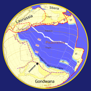
Laurasia was the more northern of two large landmasses that formed part of the Pangaea supercontinent from around 335 to 175 million years ago (Mya), the other being Gondwana. It separated from Gondwana 215 to 175 Mya during the breakup of Pangaea, drifting farther north after the split and finally broke apart with the opening of the North Atlantic Ocean c. 56 Mya. The name is a portmanteau of Laurentia and Asia.

<span class="mw-page-title-main">Tethys Ocean</span> Prehistoric ocean between Gondwana and Laurasia

The Tethys OceanTEETH-iss, TETH-, also called the Tethys Sea or the Neo-Tethys, was a prehistoric ocean during much of the Mesozoic Era and early Cenozoic Era, located between the ancient continents of Gondwana and Laurasia, before the opening of the Indian and Atlantic oceans during the Cretaceous Period.

<span class="mw-page-title-main">Panthalassa</span> Prehistoric superocean that surrounded Pangaea

Panthalassa, also known as the Panthalassic Ocean or Panthalassan Ocean, was the superocean that surrounded the supercontinent Pangaea, the latest in a series of supercontinents in the history of Earth. During the Paleozoic–Mesozoic transition c. 250 Ma it occupied almost 70% of Earth's surface. Its ocean floor has completely disappeared because of the continuous subduction along the continental margins on its circumference. Panthalassa is also referred to as the Paleo-Pacific or Proto-Pacific because the Pacific Ocean is a direct continuation of Panthalassa.

<span class="mw-page-title-main">Geology of the Himalayas</span> Origins and structure of the mountain range

The geology of the Himalayas is a record of the most dramatic and visible creations of the immense mountain range formed by plate tectonic forces and sculpted by weathering and erosion. The Himalayas, which stretch over 2400 km between the Namcha Barwa syntaxis at the eastern end of the mountain range and the Nanga Parbat syntaxis at the western end, are the result of an ongoing orogeny — the collision of the continental crust of two tectonic plates, namely, the Indian Plate thrusting into the Eurasian Plate. The Himalaya-Tibet region supplies fresh water for more than one-fifth of the world population, and accounts for a quarter of the global sedimentary budget. Topographically, the belt has many superlatives: the highest rate of uplift, the highest relief, among the highest erosion rates at 2–12 mm/yr, the source of some of the greatest rivers and the highest concentration of glaciers outside of the polar regions. This last feature earned the Himalaya its name, originating from the Sanskrit for "the abode of the snow".
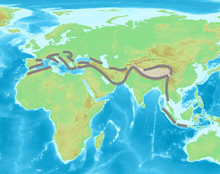
<span class="mw-page-title-main">Paleo-Tethys Ocean</span> Ocean on the margin of Gondwana between the Middle Cambrian and Late Triassic

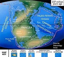
The Paleo-Tethys or Palaeo-Tethys Ocean was an ocean located along the northern margin of the paleocontinent Gondwana that started to open during the Middle Cambrian, grew throughout the Paleozoic, and finally closed during the Late Triassic; existing for about 400 million years.

<span class="mw-page-title-main">Geology of Turkey</span> Overview of the geology of Turkey

The geology of Turkey is the product of a wide variety of tectonic processes that have shaped Anatolia over millions of years, a process which continues today as evidenced by frequent earthquakes and occasional volcanic eruptions.

<span class="mw-page-title-main">Geological history of Earth</span> The sequence of major geological events in Earths past

The geological history of the Earth follows the major geological events in Earth's past based on the geological time scale, a system of chronological measurement based on the study of the planet's rock layers (stratigraphy). Earth formed about 4.54 billion years ago by accretion from the solar nebula, a disk-shaped mass of dust and gas left over from the formation of the Sun, which also created the rest of the Solar System.

<span class="mw-page-title-main">South Aegean Volcanic Arc</span> Chain of volcanic islands in the South Aegean Sea

The South Aegean Volcanic Arc is a volcanic arc in the South Aegean Sea formed by plate tectonics. The prior cause was the subduction of the African Plate beneath the Eurasian Plate, raising the Aegean arc across what is now the North Aegean Sea. It was not yet the sea, nor an arc, or at least not the one it is today, nor was there a chain of volcanoes. In the Holocene, the process of back-arc extension began, probably stimulated by pressure from the Arabian Plate compressing the region behind the arc. The extension deformed the region into its current configuration. First, the arc moved to the south and assumed its arcuate configuration. Second, the Aegean Sea opened behind the arc because the crust was thinned and weakened there. Third, magma broke through the thinned crust to form a second arc composed of a volcanic chain. And finally, the Aegean Sea Plate broke away from Eurasia in the new fault zone to the north.

<span class="mw-page-title-main">Gondwana</span> Neoproterozoic to Cretaceous landmass

Gondwana was a large landmass, sometimes referred to as a supercontinent. It was formed by the accretion of several cratons, beginning c. 800 to 650Ma with the East African Orogeny, the collision of India and Madagascar with East Africa, and was completed c.600 to 530 Ma with the overlapping Brasiliano and Kuunga orogenies, the collision of South America with Africa, and the addition of Australia and Antarctica, respectively. Eventually, Gondwana became the largest piece of continental crust of the Palaeozoic Era, covering an area of about 100,000,000 km2 (39,000,000 sq mi), about one-fifth of the Earth's surface. It fused with Euramerica during the Carboniferous to form Pangea. It began to separate from northern Pangea (Laurasia) during the Triassic, and started to fragment during the Early Jurassic. The final stages of break-up, involving the separation of Antarctica from South America and Australia, occurred during the Paleogene (from around 66 to 23 million years ago. Gondwana was not considered a supercontinent by the earliest definition, since the landmasses of Baltica, Laurentia, and Siberia were separated from it. To differentiate it from the Indian region of the same name, it is also commonly called Gondwanaland.

<span class="mw-page-title-main">Pangaea</span> Supercontinent from the late Paleozoic to early Mesozoic eras

Pangaea or Pangea was a supercontinent that existed during the late Paleozoic and early Mesozoic eras. It assembled from the earlier continental units of Gondwana, Euramerica and Siberia during the Carboniferous approximately 335 million years ago, and began to break apart about 200 million years ago, at the end of the Triassic and beginning of the Jurassic. In contrast to the present Earth and its distribution of continental mass, Pangaea was centred on the equator and surrounded by the superocean Panthalassa and the Paleo-Tethys and subsequent Tethys Oceans. Pangaea is the most recent supercontinent to have existed and the first to be reconstructed by geologists.

This is a list of articles related to plate tectonics and tectonic plates.

The Shan–Thai or Sibumasu Terrane is a mass of continental crust extending from Tibet into Southeast Asia sharing a similar geological history. The Shan–Thai Terrane rifted from Australia in the Permian and collided with the Indochina terrane in the Triassic. It extends from Malaysia, through peninsular Thailand, Myanmar, West Yunnan, to Lhasa.

<span class="mw-page-title-main">High pressure metamorphic terranes along the Bangong-Nujiang Suture Zone</span>

High pressure terranes along the ~1200 km long east-west trending Bangong-Nujiang suture zone (BNS) on the Tibetan Plateau have been extensively mapped and studied. Understanding the geodynamic processes in which these terranes are created is key to understanding the development and subsequent deformation of the BNS and Eurasian deformation as a whole.

<span class="mw-page-title-main">Geology of Iran</span>

The main points that are discussed in the geology of Iran include the study of the geological and structural units or zones; stratigraphy; magmatism and igneous rocks; ophiolite series and ultramafic rocks; and orogenic events in Iran.

<span class="mw-page-title-main">Lhasa terrane</span> Fragment of crustal material that forms present-day southern Tibet

The Lhasa terrane is a terrane, or fragment of crustal material, sutured to the Eurasian Plate during the Cretaceous that forms present-day southern Tibet. It takes its name from the city of Lhasa in the Tibet Autonomous Region, China. The northern part may have originated in the East African Orogeny, while the southern part appears to have once been part of Australia. The two parts joined, were later attached to Asia, and then were impacted by the collision of the Indian Plate that formed the Himalayas.

<span class="mw-page-title-main">Cathaysia</span> Late Paleozoic microcontinent

Cathaysia was a microcontinent or a group of terranes that rifted off Gondwana during the Late Paleozoic. They mostly correspond to the modern territory of China, which was split into the North China and South China blocks.

<span class="mw-page-title-main">Tectonic evolution of Patagonia</span>

Patagonia comprises the southernmost region of South America, portions of which lie on either side of the Argentina-Chile border. It has traditionally been described as the region south of the Rio Colorado, although the physiographic border has more recently been moved southward to the Huincul fault. The region's geologic border to the north is composed of the Rio de la Plata craton and several accreted terranes comprising the La Pampa province. The underlying basement rocks of the Patagonian region can be subdivided into two large massifs: the North Patagonian Massif and the Deseado Massif. These massifs are surrounded by sedimentary basins formed in the Mesozoic that underwent subsequent deformation during the Andean orogeny. Patagonia is known for its vast earthquakes and the damage they cause.

<span class="mw-page-title-main">South China Craton</span> Precambrian continental block located in China

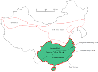
The South China Craton or South China Block is one of the Precambrian continental blocks in China. It is traditionally divided into the Yangtze Block in the NW and the Cathaysia Block in the SE. The Jiangshan–Shaoxing Fault represents the suture boundary between the two sub-blocks. Recent study suggests that the South China Block possibly has one more sub-block which is named the Tolo Terrane. The oldest rocks in the South China Block occur within the Kongling Complex, which yields zircon U–Pb ages of 3.3–2.9 Ga.

The Hellenic orogeny is a collective noun referring to multiple mountain building events that shaped the topography of the southern margin of Eurasia into what is now Greece, the Aegean Sea and western Turkey, beginning in the Jurassic. Prior to then the supercontinent, Pangaea, had divided along a divergent boundary into two continents, Gondwana land and Laurasia, separated by a primordial ocean, Paleo-Tethys Ocean. As the two continents continued to break up, Gondwana, pushed by divergent boundaries developing elsewhere, began to drift to the north, closing the sea. As it went it split off a number of smaller land masses, terranes, which preceded it to the north. The Hellenic orogeny is the story of the collision first of these terranes and then of Gondwana, reduced to Africa, with Eurasia, and the closing of Tethys to the Mediterranean. The process has been ongoing since the Jurassic and continues today.

<span class="mw-page-title-main">Central Asian Orogenic Belt</span> Phanerozoic accretionary orogen

The Central Asian Orogenic Belt (CAOB), also called the Altaids, is one of the world's largest Phanerozoic accretionary orogens, and thus a leading laboratory of geologically recent crustal growth. The orogenic belt is bounded by the East European Craton and the North China Craton in the Northwest-Southeast direction, as well as Siberia Craton and Tarim Craton in the Northeast-Southwest direction. It formed by ocean closures during Neoproterozoic to the late Phanerozoic time, from around 750 to 150 Ma. Like many other accretionary orogenic belts, the Central Asian Orogenic Belt consists of a huge amount of magmatic arcs, arc-related basins, accretionary complexes, seamounts, continental fragments and ophiolites. It is also considered a relatively distinctive collisional orogenic belt because widespread subduction-accretion complexes and arc magmatic rocks can be found in the region, but collision-related foreland basins are not common.

References

Notes

  1. 1 2 Reconstruction from Dèzes 1999, p. 16
  2. Reconstruction from Stampfli & Borel 2002, p. 27
  3. Cheng, Jian-Bo; Li, Ya-Lin; Li, Shuai; Xiao, Si-Qi; Bi, Wen-Jun; Zou, Yu (December 2022). "Reconstruction of the South Qiangtang–Zhongba–Tethyan Himalaya continental margin system along the northern Indian Plate: Insights from the paleobiogeography of the Zhongba microterrane". Journal of Asian Earth Sciences . 240: 105376. Bibcode:2022JAESc.24005376C. doi:10.1016/j.jseaes.2022.105376. S2CID   252703613 . Retrieved 2 April 2023.
  4. 1 2 Scotese & McKerrow 1990 , pp. 4, 5, 17
  5. Ruban, Al-Husseini & Iwasaki 2007 , pp. 37, 40, 43
  6. Wang, X.-D; Ueno, K.; Mizuno, Y.; Sugiyama, T. (15 June 2001). "Late Paleozoic faunal, climatic, and geographic changes in the Baoshan block as a Gondwana-derived continental fragment in southwest China". Palaeogeography, Palaeoclimatology, Palaeoecology. 170 (3–4): 197–218. Bibcode:2001PPP...170..197W. doi:10.1016/S0031-0182(01)00228-0 . Retrieved 17 October 2022.
  7. Golonka 2007 , p. 182
  8. Xu, Hai Peng; Zhang, Yi-chun; Yuan, Dong-xun; Shen, Shu Zhong (1 September 2022). "Quantitative palaeobiogeography of the Kungurian–Roadian brachiopod faunas in the Tethys: Implications of allometric drifting of Cimmerian blocks and opening of the Meso-Tethys Ocean". Palaeogeography, Palaeoclimatology, Palaeoecology. 601: 111078. Bibcode:2022PPP...60111078X. doi:10.1016/j.palaeo.2022.111078.
  9. 1 2 3 Stampfli & Borel 2002 , pp. 24, 28
  10. Metcalfe 2002 , p. 556
  11. Neumayr 1883
  12. Suess 1893; Suess 1901
  13. Hsü & Bernoulli 1978 , Paleotethys, pp. 943–944 and references therein including Carey 1958
  14. 1 2 Stöcklin 1974 , Introduction, p. 873
  15. 1 2 Stampfli 2000 , Some definitions, pp. 1–2
  16. Şengör 1984, Şengör 1987
  17. Suess 1901 , p. 22
  18. 1 2 3 Şengör et al. 1988 , pp. 119–120, 123
  19. See for example Frizon de Lamotte et al. 2011 , The Zagros Domain and Its Arabian Foreland, p. 4
  20. Frizon de Lamotte et al. 2011 , Introduction, pp. 1, 4
  21. Stampfli et al. 2001 , Initial Conditions, pp. 57–58
  22. 1 2 3 Şengör & Yilmaz 1981 , Abstract
  23. Hippolyte, J.-C.; Müller, C.; Kaymakci, N.; Sangu, E. (2010). "Dating of the Black Sea Basin: new nannoplankton ages from its inverted margin in the Central Pontides (Turkey)" (PDF). Geological Society, London, Special Publications. 340 (1): 113–136. Bibcode:2010GSLSP.340..113H. doi:10.1144/SP340.7. hdl: 11511/48215 . S2CID   128968783.
  24. Okay, Şengör & Görür 1994 , Abstract; Fig. 3, p. 269
  25. 1 2 Richards 2015 , Turkey, pp. 329–330
  26. Buchs et al. 2013 , Introduction, pp. 267–268
  27. Gamkrelidze & Shengelia 2007 , Introduction, p. 57
  28. Şengör et al. 1988 , pp. 139–140
  29. Metcalfe 2002 , p. 556; Position of the Sibumasu Terrane, pp. 562–563; Position of the Qiangtang Terrane, p. 563
  30. Zhao et al. 2015 , Geological setting and sampling, p. 3
  31. Zhao et al. 2015 , The closure of the East Paleotethys Ocean, pp. 10–11, 13
  32. Metcalfe 2002 , Position of the Lhasa Terrane, p. 563
  33. Metcalfe 1996 , Late Triassic to Late Jurassic rifting, pp. 104–105

Sources