Qiangtang terrane

Last updated
Location of Qiangtang Terranes. Bangong-Nujiang Suture Zone separates it from the Lhasa Terrane, which in turn is separated by the Indus-Yarlung suture zone from the Himalayas in the south. Bangong-Nujiang Suture Zone.png
Location of Qiangtang Terranes. Bangong-Nujiang Suture Zone separates it from the Lhasa Terrane, which in turn is separated by the Indus-Yarlung suture zone from the Himalayas in the south.
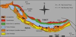
Tectonic map of the Himalaya, modified after Le Fort & Cronin (1988). Red is Transhimalaya. Green is Indus-Yarlung suture zone, north of which lies Lhasa terrane, follow by Bangong-Nujiang Suture Zone and then Qiangtang terrane. 2 2 himal tecto units.png
Tectonic map of the Himalaya, modified after Le Fort & Cronin (1988). Red is Transhimalaya. Green is Indus-Yarlung suture zone, north of which lies Lhasa terrane, follow by Bangong-Nujiang Suture Zone and then Qiangtang terrane.

The Qiantang terrane is one of three main west-east-trending terranes of the Tibetan Plateau.

Contents

During the Triassic, a southward-directed subduction along its northern margin resulted in the Jin-Shajing suture, the limit between it and the Songpan-Ganzi terrane. During the Late Jurassic and Early Cretaceous, the Lhasa terrane merged with its southern margin along the Bangong suture. [1] This suture, the closure of part of the Tethys Ocean, transformed the Qiantang terrane into a large-scale anticline. [2] The merging of the Lhasa and Qiangtang terranes resulted in the uplift of a palaeoplateau known as the Qiangtang Plateau, [3] which rapidly thinned later in the Cretaceous. [4]

The Qiantang terrane is now located at c.5,000 m (16,000 ft) above sea level, but the timing of this uplift remains debated, with estimates ranging from the Pliocene-Pleistocene (3–5 Mya) to the Eocene (35 Mya) when the plateau was first denudated. [5]

See also

Qiangtang terrane related (from south to north)

Related Research Articles

<span class="mw-page-title-main">Laurasia</span> Northern landmass that formed part of the Pangaea supercontinent

Laurasia was the more northern of two large landmasses that formed part of the Pangaea supercontinent from around 335 to 175 million years ago (Mya), the other being Gondwana. It separated from Gondwana 215 to 175 Mya during the breakup of Pangaea, drifting farther north after the split and finally broke apart with the opening of the North Atlantic Ocean c. 56 Mya. The name is a portmanteau of Laurentia and Asia.

<span class="mw-page-title-main">Tibetan Plateau</span> Plateau in Central, South and East Asia

The Tibetan Plateau, also known as the Qinghai–Tibet Plateau or the Qing–Zang Plateau or as the Himalayan Plateau in India, is a vast elevated plateau located at the intersection of Central, South and East Asia covering most of the Tibet Autonomous Region, most of Qinghai, western half of Sichuan, Southern Gansu provinces in Western China, southern Xinjiang, Bhutan, the Indian regions of Ladakh and Lahaul and Spiti as well as Gilgit-Baltistan in Pakistan, northwestern Nepal, eastern Tajikistan and southern Kyrgyzstan. It stretches approximately 1,000 kilometres (620 mi) north to south and 2,500 kilometres (1,600 mi) east to west. It is the world's highest and largest plateau above sea level, with an area of 2,500,000 square kilometres (970,000 sq mi). With an average elevation exceeding 4,500 metres (14,800 ft) and being surrounded by imposing mountain ranges that harbor the world's two highest summits, Mount Everest and K2, the Tibetan Plateau is often referred to as "the Roof of the World".

In geology, a terrane is a crust fragment formed on a tectonic plate and accreted or "sutured" to crust lying on another plate. The crustal block or fragment preserves its own distinctive geologic history, which is different from that of the surrounding areas—hence the term "exotic" terrane. The suture zone between a terrane and the crust it attaches to is usually identifiable as a fault. A sedimentary deposit that buries the contact of the terrane with adjacent rock is called an overlap formation. An igneous intrusion that has intruded and obscured the contact of a terrane with adjacent rock is called a stitching pluton.

<span class="mw-page-title-main">Indian Plate</span> A minor tectonic plate that got separated from Gondwana

The Indian Plate is a minor tectonic plate straddling the equator in the Eastern Hemisphere. Originally a part of the ancient continent of Gondwana, the Indian Plate broke away from the other fragments of Gondwana 100 million years ago, began moving north and carried Insular India with it. It was once fused with the adjacent Australian Plate to form a single Indo-Australian Plate, and recent studies suggest that India and Australia have been separate plates for at least 3 million years and likely longer. The Indian Plate includes most of modern South Asia and a portion of the basin under the Indian Ocean, including parts of South China and western Indonesia, and extending up to but not including Ladakh, Kohistan and Balochistan.

<span class="mw-page-title-main">Geology of the Himalayas</span> Origins and structure of the mountain range

The geology of the Himalayas is a record of the most dramatic and visible creations of the immense mountain range formed by plate tectonic forces and sculpted by weathering and erosion. The Himalayas, which stretch over 2400 km between the Namcha Barwa syntaxis at the eastern end of the mountain range and the Nanga Parbat syntaxis at the western end, are the result of an ongoing orogeny — the collision of the continental crust of two tectonic plates, namely, the Indian Plate thrusting into the Eurasian Plate. The Himalaya-Tibet region supplies fresh water for more than one-fifth of the world population, and accounts for a quarter of the global sedimentary budget. Topographically, the belt has many superlatives: the highest rate of uplift, the highest relief, among the highest erosion rates at 2–12 mm/yr, the source of some of the greatest rivers and the highest concentration of glaciers outside of the polar regions. This last feature earned the Himalaya its name, originating from the Sanskrit for "the abode of the snow".

<span class="mw-page-title-main">Indus-Yarlung suture zone</span> Tectonic suture in southern Tibet

The Indus-Yarlung suture zone or the Indus-Yarlung Tsangpo suture is a tectonic suture in southern Tibet and across the north margin of the Himalayas which resulted from the collision between the Indian plate and the Eurasian plate starting about 52 Ma. The north side of the suture zone is the Ladakh Batholith of the Karakoram-Lhasa Block. The rocks of the suture zone consist of an ophiolite mélanges composed of Neotethys oceanic crustal flyschs and ophiolites; the Dras Volcanics: which are basalts, dacites and minor radiolarian cherts – the remains of a mid- to late Mesozoic volcanic island arc; and the Indus Molasse which are an Eocene or later continental clastic sediments.

<span class="mw-page-title-main">Cimmeria (continent)</span> Ancient string of microcontinents that rifted from Gondwana

Cimmeria was an ancient continent, or, rather, a string of microcontinents or terranes, that rifted from Gondwana in the Southern Hemisphere and was accreted to Eurasia in the Northern Hemisphere. It consisted of parts of present-day Turkey, Iran, Afghanistan, Pakistan, Tibet, China, Myanmar, Thailand, and Malaysia. Cimmeria rifted from the Gondwanan shores of the Paleo-Tethys Ocean during the Early Permian and as the Neo-Tethys Ocean opened behind it, during the Permian, the Paleo-Tethys closed in front of it. Because the different chunks of Cimmeria drifted northward at different rates, a Meso-Tethys Ocean formed between the different fragments during the Cisuralian. Cimmeria rifted off Gondwana from east to west, from Australia to the eastern Mediterranean. It stretched across several latitudes and spanned a wide range of climatic zones.

<span class="mw-page-title-main">Geology of China</span> Overview of the geology of China

The geology of China consists of three Precambrian cratons surrounded by a number of orogenic belts. The modern tectonic environment is dominated by the continued collision of India with the rest of Asia starting 40–50 million years ago. This has formed the Himalayas and continues to deform most of China. China has vast mineral reserves, a significant earthquake risk in its western regions and rare isolated active volcanoes throughout the country.

<span class="mw-page-title-main">Gondwana</span> Neoproterozoic to Cretaceous landmass

Gondwana was a large landmass, sometimes referred to as a supercontinent. It was formed by the accretion of several cratons, beginning c. 800 to 650Ma with the East African Orogeny, the collision of India and Madagascar with East Africa, and was completed c.600 to 530 Ma with the overlapping Brasiliano and Kuunga orogenies, the collision of South America with Africa, and the addition of Australia and Antarctica, respectively. Eventually, Gondwana became the largest piece of continental crust of the Palaeozoic Era, covering an area of about 100,000,000 km2 (39,000,000 sq mi), about one-fifth of the Earth's surface. It fused with Euramerica during the Carboniferous to form Pangea. It began to separate from northern Pangea (Laurasia) during the Triassic, and started to fragment during the Early Jurassic. The final stages of break-up, involving the separation of Antarctica from South America and Australia, occurred during the Paleogene (from around 66 to 23 million years ago. Gondwana was not considered a supercontinent by the earliest definition, since the landmasses of Baltica, Laurentia, and Siberia were separated from it. To differentiate it from the Indian region of the same name, it is also commonly called Gondwanaland.

<span class="mw-page-title-main">Transhimalaya</span> Mountain range in India and Tibet, parallel to the main Himalayan range

The Trans himalaya, or "Gangdise – Nyenchen Tanglha range", is a 1,600-kilometre-long (990 mi) mountain range in China, India and Nepal, extending in a west–east direction parallel to the main Himalayan range. Located north of Yarlung Tsangpo river on the southern edge of the Tibetan Plateau, the Transhimalaya is composed of the Gangdise range to the west and the Nyenchen Tanglha range to the east.

<span class="mw-page-title-main">Altyn Tagh fault</span>

The Altyn Tagh Fault (ATF) is a 2,000 km long, active, sinistral strike-slip fault that forms the northwestern boundary of the Tibetan Plateau with the Tarim Basin. It is one of the major sinistral strike-slip structures that together help to accommodate the eastward motion of this zone of thickened crust, relative to the Eurasian Plate. A total displacement of about ~475 km has been estimated for this fault zone since the middle Oligocene, although the amount of displacement, age of initiation and slip rate are disputed.

<span class="mw-page-title-main">Bangong suture</span>

The Bangong suture zone is a key location in the central Tibet conjugate fault zone. Approximately 1,200 km long, the suture trends in an east–west orientation. Located in central Tibet between the Lhasa and Qiangtang terranes, it is a discontinuous belt of ophiolites and mélange that is 10–20 km wide, up to 50 km wide in places. The northern part of the fault zone consists of northeast striking sinistral strike-slip faults while the southern part consists of northwest striking right lateral strike-slip faults. These conjugate faults to the north and south of the Bangong intersect with each other along the Bangong-Nujiang suture zone.

<span class="mw-page-title-main">High pressure metamorphic terranes along the Bangong-Nujiang Suture Zone</span>

High pressure terranes along the ~1200 km long east-west trending Bangong-Nujiang suture zone (BNS) on the Tibetan Plateau have been extensively mapped and studied. Understanding the geodynamic processes in which these terranes are created is key to understanding the development and subsequent deformation of the BNS and Eurasian deformation as a whole.

<span class="mw-page-title-main">Karakoram fault system</span> Fault system in the Himalayan region across India and Asia

The Karakoram fault is an oblique-slip fault system in the Himalayan region across India and Asia. The slip along the fault accommodates radial expansion of the Himalayan arc, northward indentation of the Pamir Mountains, and eastward lateral extrusion of the Tibetan plateau. Current plate motions suggest that the convergence between the Indian Plate and the Eurasian Plate is around 44±5 mm per year in the western Himalaya-Pamir region and approximately 50±2 mm per year in the eastern Himalayan region.

<span class="mw-page-title-main">Lhasa terrane</span> Fragment of crustal material that forms present-day southern Tibet

The Lhasa terrane is a terrane, or fragment of crustal material, sutured to the Eurasian Plate during the Cretaceous that forms present-day southern Tibet. It takes its name from the city of Lhasa in the Tibet Autonomous Region, China. The northern part may have originated in the East African Orogeny, while the southern part appears to have once been part of Australia. The two parts joined, were later attached to Asia, and then were impacted by the collision of the Indian Plate that formed the Himalayas.

<span class="mw-page-title-main">Gangdese batholith</span> Geological structure in the south of the Lhasa terrane

The Gangdese batholith or Gangdese volcanic arc is a major geological structure in the south of the Lhasa terrane in Tibet, to the north of the Himalayas. The batholith formed around 100 million years ago, and was volcanically active for about 20 million years. It reactivated around 65 million years ago as the Indian plate approached Eurasia, and was active for another 20 million years.

<span class="mw-page-title-main">Lhasa (prefecture-level city)</span> Prefecture-level city in Tibet, China

Lhasa is a prefecture-level city, one of the main administrative divisions of the Tibet Autonomous Region of China. It covers an area of 29,274 square kilometres (11,303 sq mi) of rugged and sparsely populated terrain. Its urban center is Lhasa, with around 300,000 residents, which mostly corresponds with the administrative Chengguan District, while its suburbs extend into Doilungdêqên District and Dagzê District. The consolidated prefecture-level city contains additional five, mostly rural, counties.

<span class="mw-page-title-main">Paleogeography of the India–Asia collision system</span>

The paleogeography of the India–Asia collision system is the reconstructed geological and geomorphological evolution within the collision zone of the Himalayan orogenic belt. The continental collision between the Indian and Eurasian plate is one of the world's most renowned and most studied convergent systems. However, many mechanisms remain controversial. Some of the highly debated issues include the onset timing of continental collision, the time at which the Tibetan plateau reached its present elevation and how tectonic processes interacted with other geological mechanisms. These mechanisms are crucial for the understanding of Mesozoic and Cenozoic tectonic evolution, paleoclimate and paleontology, such as the interaction between the Himalayas orogenic growth and the Asian monsoon system, as well as the dispersal and speciation of fauna. Various hypotheses have been put forward to explain how the paleogeography of the collision system could have developed. Important ideas include the synchronous collision hypothesis, the Lhasa-plano hypothesis and the southward draining of major river systems.

<span class="mw-page-title-main">South China Craton</span> Precambrian continental block located in China

The South China Craton or South China Block is one of the Precambrian continental blocks in China. It is traditionally divided into the Yangtze Block in the NW and the Cathaysia Block in the SE. The Jiangshan–Shaoxing Fault represents the suture boundary between the two sub-blocks. Recent study suggests that the South China Block possibly has one more sub-block which is named the Tolo Terrane. The oldest rocks in the South China Block occur within the Kongling Complex, which yields zircon U–Pb ages of 3.3–2.9 Ga.

<span class="mw-page-title-main">Western Block of the North China Craton</span>

The Western Block of the North China Craton is an ancient micro-continental block mainly composed of Neoarchean and Paleoproterozoic rock basement, with some parts overlain by Cambrian to Cenozoic volcanic and sedimentary rocks. It is one of two sub-blocks within the North China Craton, located in east-central China. The boundaries of the Western Block are slightly different among distinct models, but the shapes and areas are similar. There is a broad consensus that the Western Block covers a large part of the east-central China.

References

Notes

  1. Wang et al. 2008 , Geologic setting, p. 475
  2. Xu et al. 2013 , Geologic setting, pp. 32–33
  3. Zhang, Chenyu; Wu, Lei; Chen, Wuke; Zhang, Yongshu; Xiao, Ancheng; Zhang, Junyong; Chen, Siyuan; Chen, Hanlin (1 November 2020). "Early Cretaceous foreland-like Northeastern Qaidam Basin, Tibetan Plateau and its tectonic implications: Insights from sedimentary investigations, detrital zircon U–Pb analyses and seismic profiling". Palaeogeography, Palaeoclimatology, Palaeoecology . 557: 109912. Bibcode:2020PPP...557j9912Z. doi:10.1016/j.palaeo.2020.109912. S2CID   225171627 . Retrieved 7 December 2022.
  4. Sun, Miao; Tang, Ju-Xing; Chen, Wei; Ma, Xu-Dong; Qu, Xiao-Ming; Song, Yang; Li, Xin-Yuan; Ding, Ji-Shun (March 2020). "Process of lithospheric delamination beneath the Lhasa–Qiangtang collision orogen: Constraints from the geochronology and geochemistry of Late Cretaceous volcanic rocks in the Lhasa terrane, central Tibet". Lithos . 356–357: 105219. doi:10.1016/j.lithos.2019.105219. S2CID   210619771 . Retrieved 7 December 2022.
  5. Xu et al. 2013 , Introduction, pp. 31–32

Sources