Lhasa terrane

Last updated
Lhasa terrane
Nam Tso.png
Portion of the terrane, Namtso lake to the north above Nyenchen Tanglha Mountains (white)
Coordinates: 30°N91°E / 30°N 91°E / 30; 91
Location Tibet Autonomous Region, China

The Lhasa terrane is a terrane, or fragment of crustal material, sutured to the Eurasian Plate during the Cretaceous that forms present-day southern Tibet. It takes its name from the city of Lhasa in the Tibet Autonomous Region, China. The northern part may have originated in the East African Orogeny, while the southern part appears to have once been part of Australia. The two parts joined, were later attached to Asia, and then were impacted by the collision of the Indian Plate that formed the Himalayas.

Contents

Location

Tectonic units of the Himalaya. Green is the Indus-Yarlung suture zone. Red is the Transhimalaya. Lahsa terrane and Lahsa city in the eastern part of Transhimalaya (Red). 2 2 himal tecto units.png
Tectonic units of the Himalaya. Green is the Indus-Yarlung suture zone. Red is the Transhimalaya. Lahsa terrane and Lahsa city in the eastern part of Transhimalaya (Red).
Transhimalaya and Lhasa terrane, Qiangtang terrane, Bangong-Nujiang Suture Zone. South of Indus-Yarlung suture zone is Himalayas. Bangong-Nujiang Suture Zone.png
Transhimalaya and Lhasa terrane, Qiangtang terrane, Bangong-Nujiang Suture Zone. South of Indus-Yarlung suture zone is Himalayas.

The Lhasa terrane is separated from the Himalayas to the south by the Yarlung-Tsangpo suture, and from the Qiangtang terrane to the north by the Bangong-Nujiang suture. [1] The Lhasa terrane has a Precambrian crystalline basement overlaid with sedimentary strata from the Paleozoic (c.541–252 Ma [lower-alpha 1] ) and Mesozoic (c.252–66 Ma) and containing magmatic rocks from the Paleozoic to Cenozoic (66 Ma to the present). It is thought to be the last crustal block to accrete to the Eurasian plate before it collided with the Indian plate in the Cenozoic. [2]

Origins

The Lhasa terrane consisted of two blocks before the Mesozoic, the North Lhasa Block and the South Lhasa Block. [3] The two blocks have lithology and detrital zircon ages similar to the Qiangtang terrane and to Tethyan strata in the Himalaya, which suggests these areas were nearby in Gondwana. The detrital zircon ages differ somewhat between the North and South Lhasa terranes. [4] The South Lhasa terrane appears to have evolved as part of Australia in the late Precambrian and early Paleozoic. Isotopic analysis of detrital zircons of c.1170 Ma from Paleozoic metasedimentary rocks in the Lhasa terrane shows identical values to detrital zircons of the same age from Western Australia. The detrital zircons probably came from southwest Australia's Albany-Fraser belt. [5]

The North Lhasa terrane may have been formed in part from the northern part of the East African Orogeny. Neoproterozoic oceanic crustal rocks are included in the crystalline basement of the North Lhasa terrane, which are probably from the Mozambique Ocean that formed when the Rodinia super-continent broke up. In the Late Cryogenian, around 650 Ma, the oceanic crustal basement of North Lhasa experienced HP metamorphism in the subduction zone associated with the closing of the Mozambique ocean. In the Early Paleozoic around 485 Ma it experienced MP metamorphism associated with the amalgamation of Eastern and Western Gondwana. [2]

In the Early Paleozoic the North and South Lhasa terranes and the Qiangtang terrane experienced magmatism that seems to have been the result of an Andean-type orogeny caused when the Proto-Tethys Ocean was subducted after Gondwana was finally amalgamated. In the Middle Paleozoic around 360 Ma the Lhasa and Qiangtang terranes again experienced magmatism, apparently due to the subduction of the Paleo-Tethys Ocean. [2]

Formation and evolution

Lhasa terrane approach to Qiangtang terrane Lhasa terrane approach to Qiangtang terrane.svg
Lhasa terrane approach to Qiangtang terrane
More detailed view of the tectonic evolution of the Bangong suture zone Cross section depicting the tectonic evolution of the Bangong suture zone.png
More detailed view of the tectonic evolution of the Bangong suture zone

The Lhasa terrane was formed from the North and South Lhasa terranes, which were at first separated by the Paleo-Tethys Ocean, and were joined in a suture zone in the Late Paleozoic. [2] The Paleo-Tethys Ocean that separated the North and South Lhasa terranes closed, and around 260 Ma in the Late Permian an HP metamorphic belt formed between the two blocks. Around 220 Ma in the Triassic an MP metamorphic belt formed. [2]

The Tibetan Plateau was formed from a number of continental terranes that rifted from northern Gondwana in the Paleozoic and Mesozoic, moved northward and accreted to southern Asia. The Lhasa terrane is the farthest south of these terranes. [3] The Lhasa terrane moved northward and collided with the Qiangtang terrane along the Banggongco-Nujiang Suture. [6] [7] The collision began towards the end of the late Jurassic (c.163–145 Ma), and collision activity continued until the early Late Cretaceous (c.100–66) Ma . During this period the terrane may have been shortened by at least 180 kilometres (110 mi). [1] Strata from the Lower Jurassic in the Bangong suture between the Lhasa and Qiangtang terranes differ from the rocks in the Lhasa terrane and appear to have a unique source. [8]

The collision with the Qiangtang terrane caused a peripheral foreland basin to form in the north part of the Lhasa terrane, which persisted into the Early Cretaceous. In some parts of the foreland basin the north-dipping subduction of the Neotethyan oceanic crust below the Lhasa terrane caused volcanism. The Gangdese volcanic arc was formed as this subduction continued along the southern margin of the Lhasa terrane. [9] The Gangdese batholith intrudes the southern half of the Lhasa terrain. [10] There is evidence that by the end of the Cretaceous the Southern Tibet crust was approximately twice as thick as normal. [11]

Clastic sediments found in the terrane were deposited in shallow waters during the Early Cretaceous (c.146–100 Ma.) In northern Lhasa these sediments formed in the foreland basin created during the Lhasa–Qiangtang collision. They are overlaid by marine limestone from the Aptian-Albian period, deposited in a shallow continental seaway. The Takena Formation developed in the Late Cretaceous in the foreland basin to the north of the Gangdese magmatic arc, and consists of marine limestone overlaid by fluvial red beds. [8] Outcropped folds in the Takena Formation between Lhasa and Yangbajain are upright or lean slightly to the north or south, and indicate 30% to 50% shortening in the Late Cretaceous before the Indian collision. [10]

India–Asia collision

India-Eurasia collision 70-0 Ma India 71-0 Ma.gif
India-Eurasia collision 70-0 Ma

Contact with Indian Plate began along the Yarlung-Zangbo suture around 50 Ma during the Eocene, and the two continents continue to converge. Magmatism continued in the Gangdese arc until as late as 40 Ma. [10] There are competing hypotheses about the details of the tectonic processes during the collision between the Indian and Eurasian plates. [4] At one extreme, some consider that during the collision the Indian crust was underthrust beneath the southern Asian crust, or injected into this crust. At the other extreme, some consider that the convergence was mostly accommodated by shortening of the Asian crust. [12]

The results of seismic reflection profiling, reported in 1998, indicate that there may be a midcrustal partial-melt zone under the length of the Yangbajain-Damxung graben starting at a depth of 12 to 18 kilometres (7.5 to 11.2 mi). The reflection undulates, so the melt zone may have been tectonically deformed. North-dipping reflections deep in the crust below the Gangdese batholith at a depth of 40 to 60 kilometres (25 to 37 mi) may mark the downdip of the Yarlung-Zangbo suture, or may mark a more recent reverse fault. Taken together, the results indicate that the upper crust of the Lhasa terrane was moderately shortened by the collision, with melting in the middle crust. They neither support nor rule out underthrusting or fluid injection of the Indian continental crust below the Lhasa terrane. [12]

The Linzizong Formation is distributed widely along the Gangdese Belt. It was emplaced between 69 and 43 Ma near Lhasa and between 54 and 37 Ma in southwestern Tibet. It is slightly folded and slopes gently to the north. The formation is unconformably underlain by Cretaceous sedimentary sequences more than 3,000 metres (9,800 ft) thick, which are strongly folded. [13] The results of palaeomagnetic studies of the Linzizong Formation in the Linzhou Basin and the Takena Formation reported in 2009 indicate that there was little movement of the Lhasa terrane in the Cretaceous and Early Eocene. The measurements give a northward movement of the Lhasa terrane since then of 1,847 ± 763 kilometres (1,148 ± 474 mi). This implies that there was significant crustal shortening as the collision progressed. [14] The South Lhasa terrane experienced metamorphism and magmatism in the Early Cenozoic (55–45 Ma) and metamorphism in the Late Eocene (40–30 Ma), presumably due to the collision between the continents of India and Eurasia. [2]

Strata

Sedimentary strata from the Palaeozoic are mainly Carboniferous sandstone, metasandstone, shale and phyllite, and lesser Ordovician, Silurian and Permian limestone. Precambrian strata are rarely exposed. Rocks from the Triassic include inter-bedded limestone and basaltic volcanic units, most common along the terrane's southern margin. In the northern terrane the Jurassic strata are deepwater sandstone and shale, often with ophiolitic assemblages. In the southern terrane the Jurassic strata are marine limestone and mudstone. Strata from the Lower Cretaceous are clastic mudstone, sandstone and local conglomerate units. The Lower Cretaceous clastic units are overlaid by a shallow marine limestone from the Aptian-Albian period, exposed in many places, which in some places holds Cenomanian fossils. The strata from the Upper Cretaceous are successions of arkosic fluvial sandstone and mudstone. [9]

See also

Lahsa Terrane related (from south to north)

Related Research Articles

<span class="mw-page-title-main">Acadian orogeny</span> North American orogeny

The Acadian orogeny is a long-lasting mountain building event which began in the Middle Devonian, reaching a climax in the early Late Devonian. It was active for approximately 50 million years, beginning roughly around 375 million years ago, with deformational, plutonic, and metamorphic events extending into the Early Mississippian. The Acadian orogeny is the third of the four orogenies that formed the Appalachian orogen and subsequent basin. The preceding orogenies consisted of the Potomac and Taconic orogeny, which followed a rift/drift stage in the Late Neoproterozoic. The Acadian orogeny involved the collision of a series of Avalonian continental fragments with the Laurasian continent. Geographically, the Acadian orogeny extended from the Canadian Maritime provinces migrating in a southwesterly direction toward Alabama. However, the Northern Appalachian region, from New England northeastward into Gaspé region of Canada, was the most greatly affected region by the collision.

<span class="mw-page-title-main">Geology of the Himalayas</span> Origins and structure of the mountain range

The geology of the Himalayas is a record of the most dramatic and visible creations of the immense mountain range formed by plate tectonic forces and sculpted by weathering and erosion. The Himalayas, which stretch over 2400 km between the Namcha Barwa syntaxis at the eastern end of the mountain range and the Nanga Parbat syntaxis at the western end, are the result of an ongoing orogeny — the collision of the continental crust of two tectonic plates, namely, the Indian Plate thrusting into the Eurasian Plate. The Himalaya-Tibet region supplies fresh water for more than one-fifth of the world population, and accounts for a quarter of the global sedimentary budget. Topographically, the belt has many superlatives: the highest rate of uplift, the highest relief, among the highest erosion rates at 2–12 mm/yr, the source of some of the greatest rivers and the highest concentration of glaciers outside of the polar regions. This last feature earned the Himalaya its name, originating from the Sanskrit for "the abode of the snow".

<span class="mw-page-title-main">Cimmeria (continent)</span> Ancient string of microcontinents that rifted from Gondwana

Cimmeria was an ancient continent, or, rather, a string of microcontinents or terranes, that rifted from Gondwana in the Southern Hemisphere and was accreted to Eurasia in the Northern Hemisphere. It consisted of parts of present-day Turkey, Iran, Afghanistan, Pakistan, Tibet, China, Myanmar, Thailand, and Malaysia. Cimmeria rifted from the Gondwanan shores of the Paleo-Tethys Ocean during the Early Permian and as the Neo-Tethys Ocean opened behind it, during the Permian, the Paleo-Tethys closed in front of it. Because the different chunks of Cimmeria drifted northward at different rates, a Meso-Tethys Ocean formed between the different fragments during the Cisuralian. Cimmeria rifted off Gondwana from east to west, from Australia to the eastern Mediterranean. It stretched across several latitudes and spanned a wide range of climatic zones.

<span class="mw-page-title-main">Gondwana</span> Neoproterozoic to Cretaceous landmass

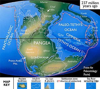
Gondwana was a large landmass, sometimes referred to as a supercontinent. It was formed by the accretion of several cratons, beginning c. 800 to 650Ma with the East African Orogeny, the collision of India and Madagascar with East Africa, and was completed c.600 to 530 Ma with the overlapping Brasiliano and Kuunga orogenies, the collision of South America with Africa, and the addition of Australia and Antarctica, respectively. Eventually, Gondwana became the largest piece of continental crust of the Palaeozoic Era, covering an area of about 100,000,000 km2 (39,000,000 sq mi), about one-fifth of the Earth's surface. It fused with Euramerica during the Carboniferous to form Pangea. It began to separate from northern Pangea (Laurasia) during the Triassic, and started to fragment during the Early Jurassic. The final stages of break-up, involving the separation of Antarctica from South America and Australia, occurred during the Paleogene (from around 66 to 23 million years ago. Gondwana was not considered a supercontinent by the earliest definition, since the landmasses of Baltica, Laurentia, and Siberia were separated from it. To differentiate it from the Indian region of the same name, it is also commonly called Gondwanaland.

<span class="mw-page-title-main">Rhenohercynian Zone</span> Fold belt of west and central Europe, formed during the Hercynian orogeny

The Rhenohercynian Zone or Rheno-Hercynian zone in structural geology describes a fold belt of west and central Europe, formed during the Hercynian orogeny. The zone consists of folded and thrust Devonian and early Carboniferous sedimentary rocks that were deposited in a back-arc basin along the southern margin of the then existing paleocontinent Laurussia.

<span class="mw-page-title-main">Carolina terrane</span> Exotic terrane from central Georgia to central Virginia in the United States

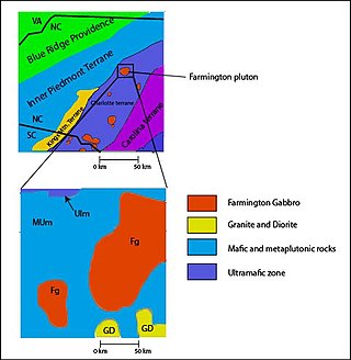
The Carolina Terrane, also called the Carolina Superterrane or Carolinia, is an exotic terrane running ~370 miles (600 km) approximately North-South from central Georgia to central Virginia in the United States. It constitutes a major part of the eastern Piedmont Province.

<span class="mw-page-title-main">Andean orogeny</span> Ongoing mountain-forming process in South America

The Andean orogeny is an ongoing process of orogeny that began in the Early Jurassic and is responsible for the rise of the Andes mountains. The orogeny is driven by a reactivation of a long-lived subduction system along the western margin of South America. On a continental scale the Cretaceous and Oligocene were periods of re-arrangements in the orogeny. The details of the orogeny vary depending on the segment and the geological period considered.

<span class="mw-page-title-main">Bangong suture</span>

The Bangong suture zone is a key location in the central Tibet conjugate fault zone. Approximately 1,200 km long, the suture trends in an east–west orientation. Located in central Tibet between the Lhasa and Qiangtang terranes, it is a discontinuous belt of ophiolites and mélange that is 10–20 km wide, up to 50 km wide in places. The northern part of the fault zone consists of northeast striking sinistral strike-slip faults while the southern part consists of northwest striking right lateral strike-slip faults. These conjugate faults to the north and south of the Bangong intersect with each other along the Bangong-Nujiang suture zone.

<span class="mw-page-title-main">High pressure metamorphic terranes along the Bangong-Nujiang Suture Zone</span>

High pressure terranes along the ~1200 km long east-west trending Bangong-Nujiang suture zone (BNS) on the Tibetan Plateau have been extensively mapped and studied. Understanding the geodynamic processes in which these terranes are created is key to understanding the development and subsequent deformation of the BNS and Eurasian deformation as a whole.

<span class="mw-page-title-main">Geology of Iran</span>

The main points that are discussed in the geology of Iran include the study of the geological and structural units or zones; stratigraphy; magmatism and igneous rocks; ophiolite series and ultramafic rocks; and orogenic events in Iran.

<span class="mw-page-title-main">Gangdese batholith</span> Geological structure in the south of the Lhasa terrane

The Gangdese batholith or Gangdese volcanic arc is a major geological structure in the south of the Lhasa terrane in Tibet, to the north of the Himalayas. The batholith formed around 100 million years ago, and was volcanically active for about 20 million years. It reactivated around 65 million years ago as the Indian plate approached Eurasia, and was active for another 20 million years.

<span class="mw-page-title-main">Famatinian orogeny</span> Paleozoic geological event in South America

The Famatinian orogeny is an orogeny that predates the rise of the Andes and that took place in what is now western South America during the Paleozoic, leading to the formation of the Famatinian orogen also known as the Famatinian belt. The Famatinian orogeny lasted from the Late Cambrian to at least the Late Devonian and possibly the Early Carboniferous, with orogenic activity peaking about 490 to 460 million years ago. The orogeny involved metamorphism and deformation in the crust and the eruption and intrusion of magma along a Famatinian magmatic arc that formed a chain of volcanoes. The igneous rocks of the Famatinian magmatic arc are of calc-alkaline character and include gabbros, tonalites, granodiorites and trondhjemites. The youngest igneous rocks of the arc are granites.

<span class="mw-page-title-main">Pre-collisional Himalaya</span>

Pre-collisional Himalaya is the arrangement of the Himalayan rock units before mountain-building processes resulted in the collision of Asia and India. The collision began in the Cenozoic and it is a type locality of a continental-continental collision. The reconstruction of the initial configuration of the rock units and the relationship between them is highly controversial, and major concerns relate to the arrangements of the different rock units in three dimensions. Several models have been advanced to explain the possible arrangements and petrogenesis of the rock units.

One of the major depositional strata in the Himalaya is the Lesser Himalayan Strata from the Paleozoic to Mesozoic eras. It had a quite different marine succession during the Paleozoic, as most parts of it are sparsely fossiliferous or even devoid of any well-defined fossils. Moreover, it consists of many varied lithofacies, making correlation work more difficult. This article describes the major formations of the Paleozoic – Mesozoic Lesser Himalayan Strata, including the Tal Formation, Gondwana Strata, Singtali Formation and Subathu Formation.

<span class="mw-page-title-main">Tectonic evolution of Patagonia</span>

Patagonia comprises the southernmost region of South America, portions of which lie on either side of the Argentina-Chile border. It has traditionally been described as the region south of the Rio Colorado, although the physiographic border has more recently been moved southward to the Huincul fault. The region's geologic border to the north is composed of the Rio de la Plata craton and several accreted terranes comprising the La Pampa province. The underlying basement rocks of the Patagonian region can be subdivided into two large massifs: the North Patagonian Massif and the Deseado Massif. These massifs are surrounded by sedimentary basins formed in the Mesozoic that underwent subsequent deformation during the Andean orogeny. Patagonia is known for its vast earthquakes and the damage they cause.

<span class="mw-page-title-main">Geology of Italy</span> Overview of the geology of Italy

The geology of Italy includes mountain ranges such as the Alps and the Apennines formed from the uplift of igneous and primarily marine sedimentary rocks all formed since the Paleozoic. Some active volcanoes are located in Insular Italy.

The geology of Argentina includes ancient Precambrian basement rock affected by the Grenville orogeny, sediment filled basins from the Mesozoic and Cenozoic as well as newly uplifted areas in the Andes.

<span class="mw-page-title-main">Paleogeography of the India–Asia collision system</span>

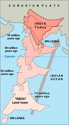
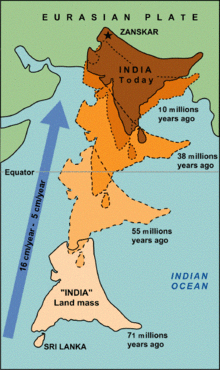
The paleogeography of the India–Asia collision system is the reconstructed geological and geomorphological evolution within the collision zone of the Himalayan orogenic belt. The continental collision between the Indian and Eurasian plate is one of the world's most renowned and most studied convergent systems. However, many mechanisms remain controversial. Some of the highly debated issues include the onset timing of continental collision, the time at which the Tibetan plateau reached its present elevation and how tectonic processes interacted with other geological mechanisms. These mechanisms are crucial for the understanding of Mesozoic and Cenozoic tectonic evolution, paleoclimate and paleontology, such as the interaction between the Himalayas orogenic growth and the Asian monsoon system, as well as the dispersal and speciation of fauna. Various hypotheses have been put forward to explain how the paleogeography of the collision system could have developed. Important ideas include the synchronous collision hypothesis, the Lhasa-plano hypothesis and the southward draining of major river systems.

<span class="mw-page-title-main">South China Craton</span> Precambrian continental block located in China

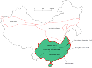
The South China Craton or South China Block is one of the Precambrian continental blocks in China. It is traditionally divided into the Yangtze Block in the NW and the Cathaysia Block in the SE. The Jiangshan–Shaoxing Fault represents the suture boundary between the two sub-blocks. Recent study suggests that the South China Block possibly has one more sub-block which is named the Tolo Terrane. The oldest rocks in the South China Block occur within the Kongling Complex, which yields zircon U–Pb ages of 3.3–2.9 Ga.

<span class="mw-page-title-main">Qiangtang terrane</span> Terrane of the Tibetan Plateau

The Qiantang terrane is one of three main west-east-trending terranes of the Tibetan Plateau.

References

  1. Ma – Millions of years ago
  1. 1 2 Ozacar 2015.
  2. 1 2 3 4 5 6 Zhang et al. 2014, p. 170–171.
  3. 1 2 Wan 2010, p. 139.
  4. 1 2 Leier et al. 2007, p. 361.
  5. Di et al. 2011.
  6. Wan 2010, p. 210.
  7. Metcalfe 1994, pp. 97–111.
  8. 1 2 Leier 2005.
  9. 1 2 Leier et al. 2007, p. 363.
  10. 1 2 3 Alsdorf, BrownNelson & Makovsky 1998, p. 502.
  11. Leier et al. 2007, p. 363–364.
  12. 1 2 Alsdorf, BrownNelson & Makovsky 1998, p. 501.
  13. Liebke et al. 2010, p. 1200.
  14. Liebke et al. 2010, p. 1199.

Sources