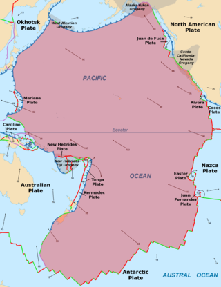
The Pacific plate is an oceanic tectonic plate that lies beneath the Pacific Ocean. At 103 million km2 (40 million sq mi), it is the largest tectonic plate.

The Explorer plate is an oceanic tectonic plate beneath the Pacific Ocean off the west coast of Vancouver Island, Canada, which is partially subducted under the North American plate. Along with the Juan de Fuca plate and Gorda plate, the Explorer plate is a remnant of the ancient Farallon plate, which has been subducted under the North American plate. The Explorer plate separated from the Juan de Fuca plate roughly 4 million years ago. In its smoother, southern half, the average depth of the Explorer plate is roughly 2,400 metres (7,900 ft) and rises up in its northern half to a highly variable basin between 1,400 metres (4,600 ft) and 2,200 metres (7,200 ft) in depth.

The Australian plate is a major tectonic plate in the eastern and, largely, southern hemispheres. Originally a part of the ancient continent of Gondwana, Australia remained connected to India and Antarctica until approximately 100 million years ago when India broke away and began moving north. Australia and Antarctica had begun rifting by 96 million years ago and completely separated a while after this, some believing as recently as 45 million years ago, but most accepting presently that this had occurred by 60 million years ago.

The Scotia Plate is a minor tectonic plate on the edge of the South Atlantic and Southern oceans. Thought to have formed during the early Eocene with the opening of the Drake Passage that separates Antarctica and South America, it is a minor plate whose movement is largely controlled by the two major plates that surround it: the Antarctic Plate and the South American Plate. The Scotia Plate takes its name from the steam yacht Scotia of the Scottish National Antarctic Expedition (1902–04), the expedition that made the first bathymetric study of the region.
The Tonga plate is a small southwest Pacific tectonic plate or microplate. It is centered at approximately 19° S. latitude and 173° E. longitude. The plate is an elongated plate oriented NNE–SSW and is a northward continuation of the Kermadec linear zone north of New Zealand. The plate is bounded on the east and north by the Pacific plate, on the northwest by the Niuafo’ou microplate, on the west and south by the Indo-Australian plate. The Tonga plate is subducting the Pacific plate along the Tonga Trench. This subduction turns into a transform fault boundary north of Tonga. An active rift or spreading center separates the Tonga plate from the Australian plate and the Niuafo’ou microplate to the west. The Tonga plate is seismically very active and is rotating clockwise.

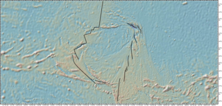
The Galápagos microplate (GMP) is a geological feature of the oceanic crust located at 1°50' N, offshore of the west coast of Colombia. The GMP is collocated with the Galápagos triple junction (GTJ), which is an atypical ridge–ridge–ridge triple junction. At the GTJ, the Pacific plate, Cocos plate, and Nazca plate meet incompletely, forming two counter-rotating microplates at the junction of the Cocos–Nazca, Pacific–Cocos, and Pacific–Nazca spreading ridges.

The Easter plate is a tectonic microplate located to the west of Easter Island off the west coast of South America in the middle of the Pacific Ocean, bordering the Nazca plate to the east and the Pacific plate to the west. It was discovered from looking at earthquake distributions that were offset from the previously perceived Nazca-Pacific Divergent boundary. This young plate is 5.25 million years old and is considered a microplate because it is small with an area of approximately 160,000 square kilometres (62,000 sq mi). Seafloor spreading along the Easter microplate's borders have some of the highest global rates, ranging from 50 to 140 millimetres /yr.

The Macquarie triple junction is a geologically active tectonic boundary located at 61°30′S161°0′E at which the historic Indo-Australian Plate, Pacific Plate, and Antarctic Plate collide and interact. The term triple junction is given to particular tectonic boundaries at which three separate tectonic plates meet at a specific, singular location. The Macquarie triple junction is located on the seafloor of the southern region of the Pacific Ocean, just south of New Zealand. This tectonic boundary was named in respect to the nearby Macquarie Island, which is located southeast of New Zealand.

The Kermadec–Tonga subduction zone is a convergent plate boundary that stretches from the North Island of New Zealand northward. The formation of the Kermadec and Tonga plates started about 4–5 million years ago. Today, the eastern boundary of the Tonga plate is one of the fastest subduction zones, with a rate up to 24 cm/year (9.4 in/year). The trench formed between the Kermadec–Tonga and Pacific plates is also home to the second deepest trench in the world, at about 10,800 m, as well as the longest chain of submerged volcanoes.

The Balmoral Reef plate is a small tectonic plate (microplate) located in the south Pacific north of Fiji. Clockwise from the north, it borders the Pacific plate, the Australian plate, Conway Reef plate, and the New Hebrides plate. The northern and western borders are a divergent boundary while the rest of the borders are transform and convergent boundaries. The Balmoral Reef plate's ocean crust is less than 12 million years old and is spreading between the New Hebrides and Tonga subduction. The plate forms the west central part of the seafloor of the North Fiji Basin.

The Caroline plate is a minor tectonic plate that straddles the Equator in the eastern hemisphere located north of New Guinea. It forms a subduction zone along the border with the Bird's Head plate and other minor plates of the New Guinea region to the south. A transform boundary forms the northern border with the Pacific plate. Along the border with the Philippine Sea plate is a convergent boundary that transitions into a rift.

The Juan Fernandez plate is a small tectonic plate (microplate) in the Pacific Ocean. With a surface area of approximately 105 km2, the microplate is located between 32° and 35°S and 109° and 112°W. The plate is located at a triple junction between the Antarctic plate, the Nazca plate, and the Pacific plate. Approximately 2,000 km to the west of South America, it is, on average, 3,000 meters deep with its shallowest point coming to approximately 1,600 meters, and its deepest point reaching 4,400 meters.

The North Bismarck plate is a small tectonic plate located in the Bismarck Sea off the northeast coast of New Guinea. It is currently regarded as a relic or inactive plate by most. At one time it was called the Manus plate, but this term was later used for a modelled microplate at the south east boundary of the North Bismarck plate.
The South Bismarck Plate is a small tectonic plate located mainly in the southern Bismarck Sea. The eastern part of New Guinea and the island of New Britain are on this plate. It is associated with high earthquake and volcanic activity as part of the New Britain subduction zone within the Pacific Ring of Fire.

The Woodlark Plate is a small almost triangular shaped tectonic plate located east of the island of New Guinea and situated mainly within the northern half of the Woodlark Basin. It is located in a very complex tectonic environment, that because of associated features, has been extensively studied since it was first proposed to exist. It is now known to be much smaller than originally proposed, mainly because of information from GPS stations on islands and sea floor studies that have fully defined its margins.

The Lau Basin is a back-arc basin at the Australian-Pacific plate boundary. It is formed by the Pacific Plate subducting under the Australian Plate. The Tonga-Kermadec Ridge, a frontal arc, and the Lau-Colville Ridge, a remnant arc, sit to the eastern and western sides of the basin, respectively. The basin has a raised transition area to the south where it joins the Havre Trough.

The West Melanesian Trench is an oceanic trench in the Bismarck Sea north of Papua New Guinea delineating the plate tectonic boundary between the Caroline and North Bismarck plates.

The Pacific Ocean evolved in the Mesozoic from the Panthalassic Ocean, which had formed when Rodinia rifted apart around 750 Ma. The first ocean floor which is part of the current Pacific Plate began 160 Ma to the west of the central Pacific and subsequently developed into the largest oceanic plate on Earth.

The Trobriand Plate was, and likely is, an independent microplate between New Guinea and the Solomon Islands. It has some unique geology, having the presence of the youngest metamorphic core complexes on earth. If there is presently active subduction between it and the Solomon Plate, at the Trobriand Trough, it continues to be an active microplate. Otherwise in the latest tectonic models it has merged with the Solomon Sea Plate, which becomes somewhat larger than predicted by Bird's 2003 model of Tectonic Plates. As a smaller Solomon Sea Plate is totally underwater, global positioning data can not resolve this issue. The area of the plate is associated with earthquake and volcanic activity as part of the Pacific Ring of Fire.


