This article relies largely or entirely on a single source .(December 2019) |
The Molucca Sea Collision Zone is postulated by paleogeologists to explain the tectonics of the area based on the Molucca Sea in Indonesia, and adjacent involved areas.
This article relies largely or entirely on a single source .(December 2019) |
The Molucca Sea Collision Zone is postulated by paleogeologists to explain the tectonics of the area based on the Molucca Sea in Indonesia, and adjacent involved areas.
The tectonic relationship of the Sangihe Plate, Halmahera Plate, and the Molucca Sea Plate, plus the volcanic Halmahera Arc and the Sangihe Arc is complex. Their interrelationship constitutes the Molucca Sea Collision Zone. The north of this zone interlinks with the Philippine Mobile Belt. Some call this linkage the Philippine–Halmahera Arc and consider it an integral part of the elongated zone of convergence extending north through the Philippines into eastern Taiwan. In the Molucca Sea Collision Zone model, the Molucca Sea Plate has been totally consumed by the arc-arc collision of the Halmahera Arc and the Sangihe Arc of eastern Indonesia. [1]
The magmatic systems are reaching the end of their life as island arcs and are becoming a single collision zone, [2] lending weight to the contention that Halmahera and Sangihe should be regarded as tectonic plates rather than volcanic arcs.
Seismic and tomographic discrepancies in the mantle up to 400 km below Mindanao in the Philippines, indicate it is a more advanced northern extension of the Molucca Sea Collision Zone. [3]

The Ring of Fire is a region around much of the rim of the Pacific Ocean where many volcanic eruptions and earthquakes occur. The Ring of Fire is a horseshoe-shaped belt about 40,000 km (25,000 mi) long and up to about 500 km (310 mi) wide.
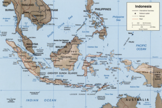
The Sunda Arc is a volcanic arc that produced the volcanoes that form the topographic spine of the islands of Sumatra, Nusa Tenggara, and Java, the Sunda Strait and the Lesser Sunda Islands. The Sunda Arc begins at Sumatra and ends at Flores, and is adjacent to the Banda Arc. The Sunda Arc is formed via the subduction of the Indo-Australian Plate beneath the Sunda and Burma plates at a velocity of 63–70 mm/year.

The Philippine Trench is a submarine trench to the east of the Philippines. The trench is located in the Philippine sea of the western North Pacific Ocean and continues NNW-SSE. It has a length of approximately 1,320 kilometres and a width of about 30 km (19 mi) from the center of the Philippine island of Luzon trending southeast to the northern Maluku island of Halmahera in Indonesia. At its deepest point, the trench reaches 10,540 meters (34,580 ft) or (5,760 fathoms).

Magmatism is the emplacement of magma within and at the surface of the outer layers of a terrestrial planet, which solidifies as igneous rocks. It does so through magmatic activity or igneous activity, the production, intrusion and extrusion of magma or lava. Volcanism is the surface expression of magmatism.
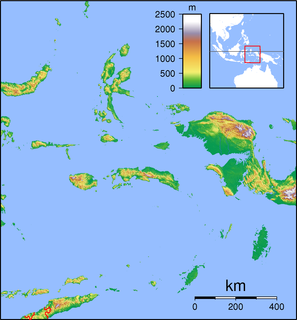
Emperor of China is a submarine volcano in the western part of the Banda Sea, Indonesia. This volcano is part of a chain with Nieuwerkerk volcano, known scientifically as the Emperor of China–Nieuwkerk (NEC) ridge, the depth of which is ranging from 3,100–2,700 metres (10,170–8,858 ft).

Cimmeria was an ancient continent, or, rather, a string of microcontinents or terranes, that rifted from Gondwana in the Southern Hemisphere and was accreted to Eurasia in the Northern Hemisphere. It consisted of parts of present-day Turkey, Iran, Afghanistan, Pakistan, Tibet, China, Myanmar, Thailand, and Malaysia. Cimmeria rifted from the Gondwanan shores of the Paleo-Tethys Ocean during the Carboniferous-earliest Permian and as the Neo-Tethys Ocean opened behind it, during the Permian, the Paleo-Tethys closed in front of it. Cimmeria rifted off Gondwana from east to west, from Australia to the eastern Mediterranean. It stretched across several latitudes and spanned a wide range of climatic zones.
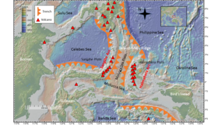
Located in the western Pacific Ocean near Indonesia, the Molucca Sea Plate has been classified by scientists as a fully subducted microplate that is part of the Molucca Sea Collision Complex. The Molucca Sea Plate represents the only known example of divergent double subduction (DDS), which describes the subduction on both sides of a single oceanic plate.

The Philippine Mobile Belt is a complex portion of the tectonic boundary between the Eurasian Plate and the Philippine Sea Plate, comprising most of the country of the Philippines. It includes two subduction zones, the Manila Trench to the west and the Philippine Trench to the east, as well as the Philippine Fault System. Within the Belt, a number of crustal blocks or microplates which have been shorn off the adjoining major plates are undergoing massive deformation.
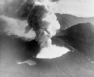
Halmahera Arc is the volcanic arc of the Halmahera region of eastern Indonesia. It is considered to belong to the Halmahera Plate within the Molucca Sea Collision Zone.
Halmahera Plate has recently (1990s) been postulated to be a microplate within the Molucca Sea Collision Zone of eastern Indonesia.
Sangihe Plate has recently (1990s) been postulated to be a microplate within the Molucca Sea Collision Zone of eastern Indonesia.
The Antarctic Peninsula, roughly 1,000 kilometres (650 mi) south of South America, is the northernmost portion of the continent of Antarctica. Like the associated Andes, the Antarctic Peninsula is an excellent example of ocean-continent collision resulting in subduction. The peninsula has experienced continuous subduction for over 200 million years, but changes in continental configurations during the amalgamation and breakup of continents have changed the orientation of the peninsula itself, as well as the underlying volcanic rocks associated with the subduction zone.

The Pacific Ocean evolved in the Mesozoic from the Panthalassic Ocean, which had formed when Rodinia rifted apart around 750 Ma. The first ocean floor which is part of the current Pacific Plate began 160 Ma to the west of the central Pacific and subsequently developed into the largest oceanic plate on Earth.

The base of rocks that underlie Borneo, an island in Southeast Asia, was formed by the arc-continent collisions, continent–continent collisions and subduction–accretion due to convergence between the Asian, India–Australia, and Philippine Sea-Pacific plates over the last 400 million years. The active geological processes of Borneo are mild as all of the volcanoes are extinct. The geological forces shaping SE Asia today are from three plate boundaries: the collisional zone in Sulawesi southeast of Borneo, the Java-Sumatra subduction boundary and the India-Eurasia continental collision.
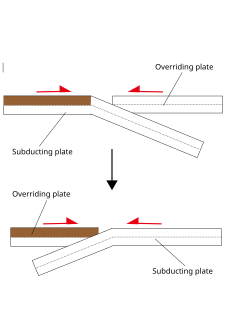
Subduction polarity reversal is a geologic process in which two converging plates switch roles: The over-lying plate becomes the down-going plate, and vice versa. There are two basic units which make up a subduction zone. This consists of an overriding plate and the subduction plate. Two plates move towards each other due to tectonic forces. The overriding plate will be on the top of the subducting plate. This type of tectonic interaction is found at many plate boundaries.

Divergent double subduction, also called outward dipping double-sided subduction, is a special type of subduction process in which two parallel subduction zones with different directions are developed on the same oceanic plate. In conventional plate tectonics theory, an oceanic plate subducts under another plate and new oceanic crust is generated somewhere else, commonly along the other side of the same plates However, in divergent double subduction, the oceanic plate subducts on two sides. This results in the closure of ocean and arc–arc collision.
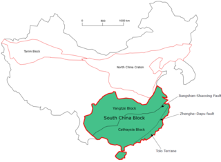
The South China Craton or South China Block is one of the Precambrian continental blocks in China. It is traditionally divided into the Yangtze Block in the NW and the Cathaysia Block in the SE. The Jiangshan–Shaoxing Fault represents the suture boundary between the two sub-blocks. Recent study suggests that the South China Block possibly has one more sub-block which is named the Tolo Terrane. The oldest rocks in the South China Block occur within the Kongling Complex, which yields zircon U–Pb ages of 3.3–2.9 Ga.
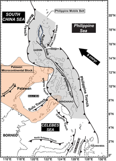
The subduction tectonics of the Philippines is the control of geology over the Philippine archipelago. The Philippine region is seismically active and has been progressively constructed by plates converging towards each other in multiple directions. The region is bounded by subduction zones, where surrounding oceanic plates to the east and west slide towards the centre of the Philippine archipelago. Subduction results in deep oceanic trenches, such as the Philippine Trench and Manila Trench, bounding the eastern and western sides of the Philippine archipelago, respectively. The Philippine archipelago is also cut along its length by a left-lateral strike-slip fault known as the Philippine Fault. The region is also known as the Philippine mobile belt due to its complex tectonic setting.
A magmatic lull is a period of declined magmatic activity in volcanically active regions. They may occur as a result of underthrusting of hinterland lithosphere beneath a volcanic arc, changes in subduction parameters such as relative velocity, direction and slab dip, arc-arc collisions and subduction hinge advance. Individual magmatic lulls may last tens of millions of years between periods of volcanicity.