Related Research Articles

Indonesia is an archipelagic country located in Southeast Asia and Oceania, lying between the Indian Ocean and the Pacific Ocean. It is located in a strategic location astride or along major sea lanes connecting East Asia, South Asia and Oceania. Indonesia is the largest archipelago in the world. Indonesia's various regional cultures have been shaped—although not specifically determined—by centuries of complex interactions with its physical environment.

The Tonga Trench is an oceanic trench located in the southwestern Pacific Ocean. It is the deepest trench in the Southern hemisphere and the second deepest on Earth after the Mariana Trench. The fastest plate-tectonic velocity on Earth is occurring at this location, as the Pacific plate is being subducted westward in the trench.

The Sunda Islands are a group of islands in the Malay Archipelago. They consist of the Greater Sunda Islands and the Lesser Sunda Islands.

The Timor Sea is a relatively shallow sea in the Indian Ocean bounded to the north by the island of Timor with Timor-Leste to the north, Indonesia to the northwest, Arafura Sea to the east, and to the south by Australia. The Sunda Trench marks the deepest point of the Timor Sea with a depth of more than 3300 metres, separating the continents of Oceania in the southeast and Asia to the northwest and north. The Timor sea is prone to earthquakes and tsunamis north of the Sunda Trench, due to its location on the Ring of Fire as well as volcanic activity and can experience major cyclones, due to the proximity from the Equator.

The Banda Sea is one of four seas that surround the Maluku Islands of Indonesia, connected to the Pacific Ocean, but surrounded by hundreds of islands, including Timor, as well as the Halmahera and Ceram Seas. It is about 1000 km (600 mi) east to west, and about 500 km (300 mi) north to south.

The Australian plate is a major tectonic plate in the eastern and, largely, southern hemispheres. Originally a part of the ancient continent of Gondwana, Australia remained connected to India and Antarctica until approximately 100 million years ago when India broke away and began moving north. Australia and Antarctica had begun rifting by 96 million years ago and completely separated a while after this, some believing as recently as 45 million years ago, but most accepting presently that this had occurred by 60 million years ago.
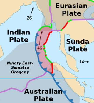
The Burma plate is a minor tectonic plate or microplate located in Southeast Asia, sometimes considered a part of the larger Eurasian plate. The Andaman Islands, Nicobar Islands, and northwestern Sumatra are located on the plate. This island arc separates the Andaman Sea from the main Indian Ocean to the west.
The Sunda Trench, earlier known as and sometimes still indicated as the Java Trench, is an oceanic trench located in the Indian Ocean near Sumatra, formed where the Australian-Capricorn plates subduct under a part of the Eurasian plate. It is 3,200 kilometres (2,000 mi) long with a maximum depth of 7,290 metres. Its maximum depth is the deepest point in the Indian Ocean. The trench stretches from the Lesser Sunda Islands past Java, around the southern coast of Sumatra to the Andaman Islands, and forms the boundary between the Indo-Australian plate and Eurasian plate. The trench is considered to be part of the alpida Belt as well as one of oceanic trenches around the northern edges of the Australian plate.

The Sunda plate is a minor tectonic plate straddling the equator in the Eastern Hemisphere on which the majority of Southeast Asia is located.

In geology, a trough is a linear structural depression that extends laterally over a distance. Although it is less steep than a trench, a trough can be a narrow basin or a geologic rift. These features often form at the rim of tectonic plates.

The Izu–Bonin–Mariana (IBM) arc system is a tectonic plate convergent boundary in Micronesia. The IBM arc system extends over 2800 km south from Tokyo, Japan, to beyond Guam, and includes the Izu Islands, the Bonin Islands, and the Mariana Islands; much more of the IBM arc system is submerged below sealevel. The IBM arc system lies along the eastern margin of the Philippine Sea Plate in the Western Pacific Ocean. It is the site of the deepest gash in Earth's solid surface, the Challenger Deep in the Mariana Trench.

In the geology of the Philippines, the Philippine Mobile Belt is a complex portion of the tectonic boundary between the Eurasian plate and the Philippine Sea plate, comprising most of the country of the Philippines. It includes two subduction zones, the Manila Trench to the west and the Philippine Trench to the east, as well as the Philippine fault system. Within the Belt, a number of crustal blocks or microplates which have been shorn off the adjoining major plates are undergoing massive deformation.

The Woodlark plate is a small almost triangular shaped tectonic plate located east of the island of New Guinea and situated mainly within the northern half of the Woodlark Basin. It is located in a very complex tectonic environment, that because of associated features, has been extensively studied since it was first proposed to exist. It is now known to be much smaller than originally proposed, mainly because of information from GPS stations on islands and sea floor studies that have fully defined its margins.

The island of Taiwan was formed approximately 4 to 5 million years ago at a convergent boundary between the Philippine Sea Plate and the Eurasian Plate. In a boundary running the length of the island and continuing southwards, the Eurasian Plate is sliding under the Philippine Sea Plate. In the northeast of the island, the Philippine Sea Plate slides under the Eurasian Plate. Most of the island comprises a huge fault block tilted to the west.

The Banda Arc is a dual chain of islands in eastern Indonesia that is around 2,300 km long. It is the result of the collision of a continent and an intra-oceanic island arc.
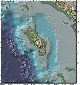
The Nias Basin is a forearc basin located off the western coast of Sumatra, Indonesia, in the Indian Ocean. The name is derived from the island that bounds its western edge, the island of Nias. The Nias Basin, the island of Nias, and the offshore, submarine accretionary complex, together form a Forearc region on the Sunda plate/Indo-Australian plate collisional/subduction boundary. The Forearc region is the area between an oceanic trench and its associated volcanic arc. The oceanic trench associated with the Nias Basin is the Sunda Trench, and the associated volcanic arc is the Sunda Arc.
The Woodlark Basin is a young geologic structural basin located in the southwestern Pacific Ocean, found to the southeast of the island country of Papua New Guinea. The basin is an extensional basin that is actively spreading and has a seafloor spreading center. The basin formed between the then Indo-Australian Plate and the Solomon microplate creating the presently independent Woodlark Plate. The Woodlark Basin has a complex geologic history dating back twenty million years to the initial opening of the basin but most of the spreading has happened in the last 3.6 million years.
The Sumatra Trench is a part of the Sunda Trench or Java Trench. The Sunda subduction zone is located in the east part of Indian Ocean, and is about 300 km (190 mi) from the southwest coast of Sumatra and Java islands. It extends over 5,000 km (3,100 mi) long, starting from Myanmar in the northwest and ending at Sumba Island in the southeast.

The Lesser Sunda Islands, now known as Nusa Tenggara Islands, are an archipelago in Indonesian archipelago. Most of the Lesser Sunda Islands are located within the Wallacea region, except for the Bali province which is west of the Wallace Line and is within the Sunda Shelf. Together with the Greater Sunda Islands to the west, they make up the Sunda Islands. The islands are part of a volcanic arc, the Sunda Arc, formed by subduction along the Sunda Trench in the Java Sea. In 1930 the population was 3,460,059; today slightly over 15.5 million people live on the islands. Etymologically, Nusa Tenggara means "Southeast Islands" from the words of nusa which means 'island' from Old Javanese language and tenggara means 'southeast'.

The East Luzon Trough is an oceanic trench north of the Philippine Trench and east of the island of Luzon. The trench is located near the Philippine orogeny and located in the southeastern region of the Philippine Sea Plate. The depth of the trough is 5,700 meters. The East Luzon Trough formed during the Eocene and Oligocene epoch, 40–24 million years ago.
References
- 1 2 "Chapter II (Geology of Timor-Leste)" (PDF). Atlas of mineral resources of the ESCAP region Volume 17 Geology and Mineral Resources of Timor-Leste. United Nations Economic and Social Commission for Asia and the Pacific. 24 December 2003. Archived from the original (PDF) on 20 May 2005.
9°00′00″S127°00′00″E / 9.0000°S 127.0000°E
| | This article about a specific oceanic location or ocean current is a stub. You can help Wikipedia by expanding it. |
| | This tectonics article is a stub. You can help Wikipedia by expanding it. |