Seram is the largest and main island of Maluku province of Indonesia, despite Ambon Island's historical importance. It is located just north of the smaller Ambon Island and a few other adjacent islands, such as Saparua, Haruku, Nusa Laut and the Banda Islands.
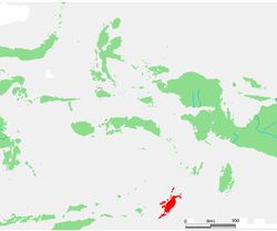
The Aru Islands Regency is a group of about 95 low-lying islands in the Maluku Islands of eastern Indonesia. It also forms a regency of Maluku Province, with a land area of 6,426.77 km2 (2,481.39 sq mi). At the 2011 Census the Regency had a population of 84,138; the 2020 Census produced a total of 102,237, and the official estimate as at mid 2023 was 108,834. Some sources regard the archipelago as part of Asia, while others regard it as part of Melanesia.

The Kai Islands of Indonesia are a group of islands in the southeastern part of the Maluku Islands, located in the province of Maluku. The Moluccas have been known as the Spice Islands due to regionally specific plants such as nutmeg, mace, and cloves that originally intrigued the European nations of the 16th century.

The Barat Daya Islands are a group of islands in the Maluku province of Indonesia. The Indonesian phrase barat daya means 'south-west'.

Maluku is a province of Indonesia. It comprises the central and southern regions of the Maluku Islands. The largest city and capital of Maluku province is Ambon on the small Ambon Island. It is directly adjacent to North Maluku, Southwest Papua, and West Papua in the north, Central Sulawesi, and Southeast Sulawesi in the west, Banda Sea, Australia, East Timor and East Nusa Tenggara in the south and Arafura Sea, Central Papua and South Papua in the east. The land area is 46,150.92 km2, and the total population of this province at the 2010 census was 1,533,506 people, rising to 1,848,923 at the 2020 census, the official estimate as at mid 2022 was 1,881,727. Maluku is located in Eastern Indonesia.

Tidore is a city, island, and archipelago in the Maluku Islands of eastern Indonesia, west of the larger island of Halmahera. Part of North Maluku Province, the city includes the island of Tidore together with a large part of Halmahera Island to its east. In the pre-colonial era, the Sultanate of Tidore was a major regional political and economic power, and a fierce rival of nearby Ternate, just to the north.

The Babar Islands(Indonesian: Kepulauan Babar) are located in Maluku Province, Indonesia between latitudes 7 degrees 31 minutes South to 8 degrees 13 minutes South and from longitudes 129 degrees 30 minutes East to 130 degrees 05 minutes East. The group now constitutes five districts (kecamatan) within the Maluku Barat Daya Regency of Maluku province.
The Obi Islands are a group of 42 islands in the Indonesian province of North Maluku, north of Buru and Ceram, and south of Halmahera. With a total area of 3,048.08 km2, they had a population of 41,455 at the 2010 Census and 50,760 at the 2020 Census. The official estimate as at mid 2022 was 52,588.

Solor is a volcanic island located off the eastern tip of Flores island in the Lesser Sunda Islands of Indonesia, in the Solor Archipelago. The island supports a small population that has been whaling for hundreds of years. They speak the languages of Adonara and Lamaholot. There are at least five volcanoes on this island which measures only 40 kilometres by 6 kilometres. The island's area is 226.34 square kilometres, and it had a population of 34,029 at the 2020 Census. The official estimate as at mid 2022 was 35,891.
Wetar is a tropical island which belongs to the Indonesian province of Maluku and is the largest island of the Maluku Barat Daya Islands Regency of the Maluku Islands. It lies east of the Lesser Sunda Islands, which include nearby Alor and Timor, but it is politically part of the Maluku Islands. To the south, across the Wetar Strait, lies the island of Timor; at its closest it is 50 km away. To the west, across the Ombai Strait, lies the island of Alor. To the southwest is the very small island of Liran, which is also part of West Wetar District and, further southwest, the small East Timorese island of Atauro. To the north is the Banda Sea and to the east lie Romang and Damar Islands, while to the southeast lie the other principal islands of the Barat Daya Islands. Including Liran and other small offshore islands, Wetar has an area of 2,651.8 km2, and had a population of 7,916 at the 2010 Census and 8,622 at the 2020 Census; the official estimate as at mid 2023 was 11,109. Administratively, Wetar is divided into four of the districts (kecamatan) of the Maluku Barat Daya Regency.

The Letti Islands of Indonesia are part of the Maluku Islands, in southwest Maluku Province. They are also called the "Lemola" Archipelago, from the initial two letters of each of the three main islands, Letti, Moa and Lakor; each of the three islands now constitutes a separate administrative district (kecamatan) within the Maluku Barat Daya Regency
Merauke, also known as the District of Merauke, is a large town in South Papua, Indonesia. It is also the administrative centre of Merauke Regency. It is considered the easternmost city in Indonesia. The town was originally called Ermasoe. It is next to the Maro River where the Port of Merauke is located. As of the 2010 census, Merauke had a population of 87,634 which at the 2020 Census had increased to 102,351.
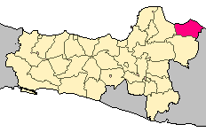
Rembang Regency is a regency on the extreme northeast coast of Central Java Province, on the island of Java in Indonesia. The regency covers an area of 1,036.70 km2 on Java, and it had a population of 591,359 at the 2010 Census and 645,333 at the 2020 Census; the official estimate as of mid-2023 was 660,166, of whom 331,870 were males and 328,296 were females. Its administrative capital is the town of Rembang.

Central Maluku Regency is a regency of Maluku Province of Indonesia. The Regency covers an area of 11,595.57 km2, and had a population of 361,698 at the 2010 Census, and 423,094 at the 2020 Census. The official estimate as at mid 2022 was 427,050. The principal town lies at Masohi, on Seram Island. The regency (kebupaten) is composed of the central part of the island of Seram, the Banda Islands, and the Lease Islands, together with those parts of Ambon Island which are outside the City of Ambon.

Southeast Maluku Regency is a regency of Maluku, Indonesia. It is coincident with the Kei Islands, except that the city of Tual, although within the Kei Islands geographically and the seat of the Regency's administration, is since 17 July 2007 technically independent of the Regency. The land area of the Regency is 1,031.01 km2, while the sea area administered by the Regency was 3,181 km2; it had a population of 96,442 at the 2010 Census; this increased to 121,511 at the 2020 Census, and the official estimate as at mid 2023 was 129,034.

Southwest Maluku Regency is a regency of Maluku Province, Indonesia. Geographically it forms the most eastern portion of the Lesser Sunda Islands, although it has never been administratively included with them, and politically has always comprised a part of the Maluku Province. It comprises a number of islands and island groups in the south of the province, including Lirang Island, Wetar Island, Kisar Island, Romang Island, the Letti Islands, the Damer Islands, the Sermata Islands and the Babar Islands. The total land area is 4,581.06 km2, and the population was 70,714 at the 2010 Census and 81,928 at the 2020 Census; the official estimate as at mid 2023 was 93,766.
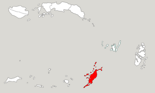
Tanimbar Islands Regency is a regency of Maluku province, Indonesia, consisting primarily of the Tanimbar Islands. The Regency covers a land area of 10,102 km2, and it had a population of 105,341 at the 2010 Census and 123,572 at the 2020 Census; the official estimate as at mid 2022 was 124,787. The principal town and administrative centre lies at Saumlaki in Tanimbar Selatan District.
Masohi is a coastal town on the Indonesian island of Seram. It is the capital of the Central Maluku Regency. It was the site of a detention camp for political prisoners in the 1970s. It had 36,433 inhabitants at the 2020 Census. The headquarters of Manusela National Park is located in Masohi.

Saumlaki is a town in Tanimbar Islands Regency, Indonesia. It is the seat of Tanimbar Islands Regency, as well as the biggest town in the island of Yamdena. Previously a small village, it has grown to a relatively sizeable town due to its political status as a regency seat. Most of the regency's infrastructure is concentrated in Saumlaki. The administrative location of the town is in the kelurahan of Saumlaki, inside South Tanimbar District. The urban settlement extends outside of the administrative boundaries to surrounding communities such as the villages of Olilit and Sifnana.