Ambon Island is part of the Maluku Islands of Indonesia. The island has an area of 743.37 km2 (287.02 sq mi) and is mountainous, well watered, and fertile. Ambon Island consists of two territories: the city of Ambon to the south, and three districts (kecamatan) of the Central Maluku Regency to the north. The main city and seaport is Ambon, which is also the capital of Maluku province, while those districts of Maluku Tengah Regency situated on Ambon Island had a 2020 Census population of 128,069. By mid 2023 those populations were estimated to have become 354,052 and 128,754 respectively, resulting in an all-island population of 482,806.

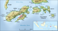
Seram is the largest and main island of Maluku province of Indonesia, despite Ambon Island's historical importance. It is located just north of the smaller Ambon Island and a few other adjacent islands, such as Saparua, Haruku, Nusa Laut and the Banda Islands.

Ambon is the capital and largest city of the Indonesian province of Maluku. This city is also known as Ambon Manise, which means "beautiful" or "pretty" Ambon in the Ambonese language. It covers a land area of 359.45 km2, and had a population of 331,254 at the 2010 Census and 347,288 at the 2020 Census; the official estimate as at mid 2023 was 354,052. The city is divided into five administrative districts – namely Nusaniwe, Sirimau, Teluk Ambon, Baguala and Leitimur Selatan. Known as Indonesia's music city, Ambon became the first city in Southeast Asia to be recognised as the UNESCO City of Music in 2019.

Maluku is a province of Indonesia. It comprises the central and southern regions of the Maluku Islands. The largest city and capital of Maluku province is Ambon on the small Ambon Island. It is directly adjacent to North Maluku, Southwest Papua, and West Papua in the north, Central Sulawesi, and Southeast Sulawesi in the west, Banda Sea, Australia, East Timor and East Nusa Tenggara in the south and Arafura Sea, Central Papua and South Papua in the east. The land area is 57803.81 km2, and the total population of this province at the 2010 census was 1,533,506 people, rising to 1,848,923 at the 2020 census, the official estimate as at mid 2023 was 1,908,753. Maluku is located in Eastern Indonesia.

Thomas Matulessy, also known as Kapitan Pattimura or simply Pattimura, was a famous Ambonese soldier who became a symbol of both the Maluku and Indonesian struggle for independence, praised by President Sukarno and declared a national hero by President Suharto. He has several namesakes in both the Netherlands and in the Indonesian archipelago.

South Aceh Regency is a regency in the Aceh province of Indonesia. It is located on the west coast of the island of Sumatra. The regency covers an area of 4,173.82 square kilometres and had a population of 202,251 at the 2010 Census, 224,588 in 2015 and 232,414 at the 2020 Census; the official estimate as at mid 2023 was 239,475 . Its population density was thus 48.5 inhabitants/km2 at the 2010 census, 53.8 inhabitants/km2 in 2015, 55.7 inhabitants/km2 at the 2020 census, and 57.4 inhabitants/km2 in mid 2023. The seat of the regency government is at Tapaktuan.
Kefamenanu is a town and capital of the administrative district (kecamatan) of Kota Kefamenanu and of the North Central Timor Regency in West Timor, Indonesia. A road connects it to Halilulik and Kota Atambua to the northeast. It had a population of 43,058 at the 2010 Census and 47,766 at the 2020 Census; the official estimate in mid 2023 was 49,589. The town hosts the University of Timor, one of the two public universities in the Indonesian part of the island.
West Halmahera Regency is a regency in North Maluku Province of Indonesia. The regency was created on 25 February 2003 from the western districts of the former North Maluku Regency, and is now bounded by North Halmahera Regency to the north and east, while to the south it borders both East Halmahera Regency and that portion of the city of Tidore on the mainland of Halmahera. It covers an area of 2,239.11 km2, and it had a population of 100,424 people at the 2010 Census and 132,349 at the 2020 Census; the official estimate as at mid 2023 was 137,543. The capital lies at Jailolo (town).
Central Halmahera Regency is a regency of North Maluku Province, Indonesia. The regency was originally formed on 15 August 1990 from part of the former North Maluku Regency, but on 25 February 2003 parts of the new regency were split off to form a separate East Halmahera Regency and the city of Kota Tidore Kepulauan. It now comprises just the southern half of the southeastern peninsula of Halmahera Island, together with part of the southern peninsula of that island.

East Halmahera Regency is a regency of North Maluku Province of Indonesia, and occupies the northeastern peninsula of Halmahera island, together with the northern half of the southeastern peninsula of that island. It was created on 25 February 2003 from part of Central Halmahera Regency, and covers a land area of 6,515.74 km2. It had a population of 72,880 at the 2010 Census and 91,707 at the 2020 Census; the official estimate as at mid 2023 was 97,895. The capital lies at the town of Maba in Kota Maba District.

Paser Regency is the southernmost regency (kabupaten) within the East Kalimantan province of Indonesia. It was created in 1959, originally spelt "Pasir Regency", but renamed "Paser" in 2007; however its northeastern districts were split off on 10 April 2002 to form the new Penajam North Paser Regency. The residual regency covers an area of 11,603.94 km2, and it had a population of 230,316 at the 2010 Census and 275,452 at the 2020 Census; the official estimate as at mid-2023 was 303,424. Its administrative centre is the town of Tana Paser.

East Kotawaringin Regency is one of the thirteen regencies which comprise the Central Kalimantan Province on the island of Kalimantan (Borneo), Indonesia. It originally covered a much larger part of the province, having been split from a single Kotawaringin Regency on 26 June 1959 into separate regencies for East and West Kotawaringin, but on 10 April 2002 several districts in the west of the regency were split off to form the new Seruyan Regency, and several districts in the east of the regency were similarly split off to form the new Katingan Regency. The area of the residual East Kotawaringin Regency is 16,796 km2, and its population was 374,175 at the 2010 Census, and 428,900 at the 2020 Census; the official estimate as at mid 2023 was 443,359. The town of Sampit is the capital of East Kotawaringin Regency.

Central Maluku Regency is a regency of Maluku Province of Indonesia. The Regency covers an area of 11,595.57 km2, and had a population of 361,698 at the 2010 Census, and 423,094 at the 2020 Census. The official estimate as at mid 2023 was 430,798. The principal town lies at Masohi, on Seram Island. The regency (kebupaten) is composed of the central part of the island of Seram, the Banda Islands, and the Lease Islands, together with those parts of Ambon Island which are outside the City of Ambon.
Masohi is a coastal town on the Indonesian island of Seram. It is the capital of the Central Maluku Regency. It was the site of a detention camp for political prisoners in the 1970s. It had 36,433 inhabitants at the 2020 census. The headquarters of Manusela National Park is located in Masohi.

Haruku Island is an island in Central Maluku Regency, Maluku Province, Indonesia - lying east of Ambon Island, off the southern coast of Seram and just west of Saparua. It is administered as a single district, Haruku Island District, with a land area of 150 km2 and a population of 24,207 at the 2010 census and 27,390 at the 2020 Census; the official estimate as at mid 2023 was 26,551. The inhabitants of Haruku speak the Haruku language, as well as Indonesian and Ambonese Malay.
Nusa Laut is the smallest of the three inhabited island in the Lease Islands group situated east of Ambon Island, in Indonesia's Maluku province. It lies just off the south-western corner of Saparua island, separated from it by a deep channel. The island's coasts are fringed by a drying reef.
The Lease Islands, formerly called the Uliasers or Uliassers, are a group of three inhabited islands, lying immediately to the south of Seram and east of Ambon Island in the province of Maluku, in Indonesia. The three inhabited islands, from west to east, are Haruku, Saparua and Nusa Laut, while tiny uninhabited Molana is administratively part of Saparua District; these islands constitute four administrative districts (kecamatan) within Central Maluku Regency.
Amahai is a village (desa) and an administrative district (kecamatan) on the south coast of the Indonesian island of Seram, in Central Maluku Regency. The village, which serves as the administrative centre of the eponymous district, lies to the south of Masohi town, both being situated on the coast of Elpaputih Bay, and they are surrounded on the landward sides by Amahai District. Teon Nila Serua District is also a semi-enclave within Amahai District, which surrounds it on all sides except the west. Daily speedboats connect Tulehu with Amahai, which is Seram's main port.