The Territory of Ashmore and Cartier Islands is an uninhabited external territory of Australia consisting of four low-lying tropical islands in two separate reefs, and the 12 nautical mile territorial sea generated by the islands. The territory is located in the Indian Ocean situated on the edge of the continental shelf, about 320 km (199 mi) off the northwest coast of Australia and 144 km (89 mi) south of the Indonesian island of Rote.

Bali is a province of Indonesia and the westernmost of the Lesser Sunda Islands. Located east of Java and west of Lombok, the province includes the island of Bali and a few smaller neighbouring islands, notably Nusa Penida, Nusa Lembongan, and Nusa Ceningan. The provincial capital, Denpasar, is the most populous city in the Lesser Sunda Islands and the second largest, after Makassar, in Eastern Indonesia. Bali is the only Hindu-majority province in Indonesia, with 83.5% of the population adhering to Balinese Hinduism.

Flores is one of the Lesser Sunda Islands, a group of islands in the eastern half of Indonesia. The population was 1,831,000 in the 2010 census and the largest town is Maumere. The name Flores is derived from the Portuguese for "flowers".

Timor is an island at the southern end of Maritime Southeast Asia, north of the Timor Sea. The island is divided between the sovereign states of East Timor on the eastern part and Indonesia on the western part. The Indonesian part, also known as West Timor, constitutes part of the province of East Nusa Tenggara. Within West Timor lies an exclave of East Timor called Oecusse District. The island covers an area of 30,777 square kilometres. The name is a variant of timur, Malay for "east"; it is so called because it lies at the eastern end of the Lesser Sunda Islands. Mainland Australia is less than 500 km away, separated by the mentioned Timor Sea.

Dili, also known as “City of Peace”, is the capital, largest city, chief port, and commercial centre of East Timor (Timor-Leste). Dili is part of a free trade zone, the Timor Leste–Indonesia–Australia Growth Triangle (TIA-GT).
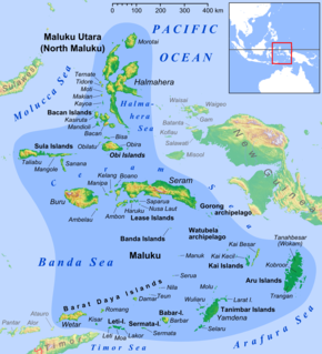
The Maluku Islands or the Moluccas are an archipelago in eastern Indonesia. Tectonically they are located on the Halmahera Plate within the Molucca Sea Collision Zone. Geographically they are located east of Sulawesi, west of New Guinea, and north and east of Timor.
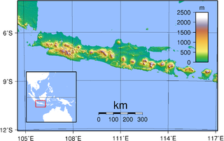
Java is an island of Indonesia, bordered by the Indian Ocean on the south and the Java Sea on the north. With a population of over 141 million or 145 million, Java is the home to 56.7 percent of the Indonesian population and is the world's most populous island. The Indonesian capital city, Jakarta, is located on its northwestern coast. Much of Indonesian history took place on Java. It was the center of powerful Hindu-Buddhist empires, the Islamic sultanates, and the core of the colonial Dutch East Indies. Java was also the center of the Indonesian struggle for independence during the 1930s and 1940s. Java dominates Indonesia politically, economically and culturally. Four of Indonesia's eight UNESCO world heritage sites are located in Java: Ujung Kulon National Park, Borobudur Temple, Prambanan Temple, and Sangiran Early Man Site.

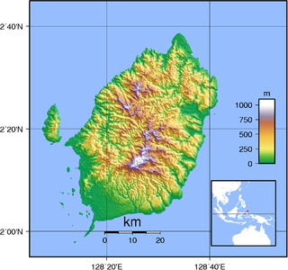
Ambon Island is part of the Maluku Islands of Indonesia. The island has an area of 775 km2 (299 sq mi) and is mountainous, well watered, and fertile. Ambon Island consists of two territories - the city of Ambon to the south and various districts (kecamatan) of the Central Maluku Regency to the north. The main city and seaport is Ambon, which is also the capital of Maluku province, while those districts of Maluku Tengah Regency situated on Ambon Island had a 2014 population of 132,377. Ambon has an airport and is home to the Pattimura University and Open University, state universities, and a few private universities, which include Darussalam University and Universitas Kristen Indonesia Maluku (UKIM).
Makassar is the capital of the Indonesian province of South Sulawesi. It is the largest city in the region of Eastern Indonesia and the fifth largest city in Indonesia after Jakarta, Surabaya, Bandung, and Medan. From 1971 to 1999, the city was named after one of its subdistricts, Ujung Pandang. The city is located on the southwest coast of the island of Sulawesi, facing the Makassar Strait.
Ambon is the capital and most populous city of the Indonesian province of Maluku. This city is also known as "Ambon Manise," which means "beautiful" or "pretty". It covers a land area of 298.61 km2, and had an estimated 2016 population of 427,934. The city is divided into five administrative districts (kecamatan) - namely Nusaniwe, Sirimau, Teluk Ambon, Baguala and Leitimur Selatan.
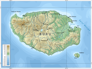
Buru is the third largest island within Maluku Islands of Indonesia. It lies between the Banda Sea to the south and Seram Sea to the north, west of Ambon and Seram islands. The island belongs to Maluku province and includes the Buru and South Buru regencies. Their administrative centers, Namlea and Namrole, respectively, have ports and the largest towns of the island. There is a military airport at Namlea which supports civilian cargo transportation.
Maluku is a province of Indonesia. It comprises the central and southern regions of the Maluku Islands. The main city and capital of Maluku province is Ambon on the small Ambon Island. The total population of this province in 2010 in the census results amounted to 1,533,506 people. Maluku is located in Eastern Indonesia. It is directly adjacent to North Maluku and West Papua in the north, Central Sulawesi, and Southeast Sulawesi in the west, Banda Sea, East Timor and East Nusa Tenggara in the south and Arafura Sea and Papua in the east.

Samarinda is the capital of the Indonesian province of East Kalimantan on the island of Borneo. The city lies on the banks of the Mahakam River. It is the most populous city on the entire Borneo island, with an estimated population of 842,691, up from 726,223 at the 2010 Census. Although it is the capital of East Kalimantan, some government institutions such as the Police, Indonesian Army District VI Of Tanjung Pura, and Pelabuhan Indonesia are located on the island. Samarinda is known for its traditional food amplang, as well as the cloth sarung samarinda. The city also has a bridge connecting its river banks, Mahakam Bridge. The city center is on one side and the other side is named Samarinda Seberang.
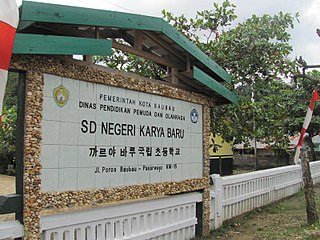
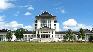
Cia-Cia, also known as Buton(ese), is an Austronesian language spoken principally around the town of Baubau on the southern tip of Buton Island off the southeast coast of Sulawesi in Indonesia.

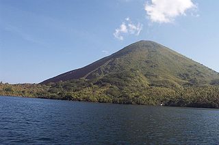
Ambelau or Ambalau is a volcanic island in the Banda Sea within Maluku Islands of Indonesia. The island forms an administrative district which is part of the South Buru Regency of Maluku province, Indonesia. It has a land area of 201.7 km2, and had a population of 6,846 at the 2010 Census. The administrative center is Wailua, a settlement located at the south of the island. About half of the island's population is composed of indigenous Ambelau people who speak Ambelau language; the other half are mostly immigrants from the nearby Maluku Islands and Java.
The Maluku Islands sectarian conflict was a period of ethno-political conflict along religious lines, which spanned the Indonesian islands that compose the Maluku archipelago, with particularly serious disturbances in Ambon and Halmahera Islands. The duration of the conflict is generally dated from the start of the Reformasi era in early 1999 to the signing of the Malino II Accord on 13 February 2002.
Morotai Island is an island in the Halmahera group of eastern Indonesia's Maluku Islands (Moluccas). It is one of Indonesia's northernmost islands.

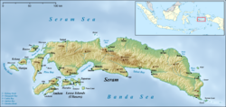
Loki is a small town on the southwestern coast of the Indonesian island of Seram, situated between the towns of Kulur and Ariate. On 21–22 August 1999 there was violent conflict in the area and other settlements such as Piru, Ariate, Laala and Wailissa, which resulted in 12 deaths in total on the island.