Luhu, Indonesia

Last updated
Luhu
Town
Seram en.png
Red pog.svg
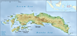
Luhu
Location in Seram Island
Coordinates: 3°27′26″S127°57′13″E / 3.45722°S 127.95361°E / -3.45722; 127.95361 Coordinates: 3°27′26″S127°57′13″E / 3.45722°S 127.95361°E / -3.45722; 127.95361
Country Indonesia
Province Maluku
Regency West Seram
Time zone UTC+8 (WITA)

Luhu is a small town on the southwestern coast of the Indonesian island of Seram. [1] It lies near the end of the Hoamoal Peninsula, between Kulur and Urieng on the tip. Luhu is noted for its Makassan traders, exporting cloves from the port. [2] The clove industry took off in the first half of the 17th century, at the time when Luhu was a vassal of Tidore. [3] The Dutch secured a military post at Luhu. [4] The Luhu language is spoken in the vicinity. [5]

Related Research Articles

<span class="mw-page-title-main">Banda Islands</span> Volcanic islands in the Banda Sea, Maluku, Indonesia

The Banda Islands are a volcanic group of ten small volcanic islands in the Banda Sea, about 140 km (87 mi) south of Seram Island and about 2,000 km (1,243 mi) east of Java, and constitute an administrative district (kecamatan) within the Central Maluku Regency in the Indonesian province of Maluku. The islands rise out of 4-to-6-kilometre deep ocean and have a total land area of approximately 172 square kilometres (66 sq mi). They had a population of 18,544 at the 2010 Census and 20,924 at the 2020 Census. Until the mid-19th century the Banda Islands were the world's only source of the spices nutmeg and mace, produced from the nutmeg tree. The islands are also popular destinations for scuba diving and snorkeling. The main town and administrative centre is Banda Neira, located on the island of the same name.

<span class="mw-page-title-main">Spice</span> Food flavoring

A spice is a seed, fruit, root, bark, or other plant substance primarily used for flavoring or coloring food. Spices are distinguished from herbs, which are the leaves, flowers, or stems of plants used for flavoring or as a garnish. Spices are sometimes used in medicine, religious rituals, cosmetics, or perfume production. For example, vanilla is commonly used as an ingredient in fragrance manufacturing.

<span class="mw-page-title-main">Maluku Islands</span> Archipelago in eastern Indonesia, also called the Spice Islands

The Maluku Islands or the Moluccas are an archipelago in the east of Indonesia. Tectonically they are located on the Halmahera Plate within the Molucca Sea Collision Zone. Geographically they are located east of Sulawesi, west of New Guinea, and north and east of Timor. Lying within Wallacea, the Maluku Islands have been considered as a geographical and cultural intersection of Asia and Oceania.

<span class="mw-page-title-main">Ambon Island</span> Island of Indonesia

Ambon Island is part of the Maluku Islands of Indonesia. The island has an area of 743.37 km2 (287.02 sq mi) and is mountainous, well watered, and fertile. Ambon Island consists of two territories: the city of Ambon to the south and various districts (kecamatan) of the Central Maluku Regency to the north. The main city and seaport is Ambon, which is also the capital of Maluku province, while those districts of Maluku Tengah Regency situated on Ambon Island had a 2020 Census population of 128,069. Ambon has an airport and is home to the Pattimura University and Open University, state universities, and a few private universities, which include Darussalam University and Universitas Kristen Indonesia Maluku (UKIM).

<span class="mw-page-title-main">Spice trade</span> Historic international commerce

The spice trade involved historical civilizations in Asia, Northeast Africa and Europe. Spices such as cinnamon, cassia, cardamom, ginger, pepper, nutmeg, star anise, clove, and turmeric were known and used in antiquity and traded in the Eastern World. These spices found their way into the Near East before the beginning of the Christian era, with fantastic tales hiding their true sources.

<span class="mw-page-title-main">Buru</span> Island in Maluku, Indonesia

Buru is the third largest island within the Maluku Islands of Indonesia. It lies between the Banda Sea to the south and Seram Sea to the north, west of Ambon and Seram islands. The island belongs to Maluku province and includes the Buru and South Buru regencies. Their administrative centers, Namlea and Namrole, respectively, have ports and are the largest towns of the island, served by Namlea Airport and Namrole Airport.

<span class="mw-page-title-main">Maluku (province)</span> Province of Indonesia

Maluku is a province of Indonesia. It comprises the central and southern regions of the Maluku Islands. The main city and capital of Maluku province is Ambon on the small Ambon Island. The land area is 46,150.92 km2, and the total population of this province at the 2010 census was 1,533,506 people, rising to 1,848,923 at the 2020 census. The official estimate as at mid 2022 was 1,881,727. Maluku is located in Eastern Indonesia. It is directly adjacent to North Maluku, Southwest Papua, and West Papua in the north, Central Sulawesi, and Southeast Sulawesi in the west, Banda Sea, East Timor and East Nusa Tenggara in the south and Arafura Sea, Central Papua and South Papua in the east.

<span class="mw-page-title-main">Nuaulu people</span> Tribe in Indonesia

The Nuaulu, Naulu or Nunuhai are a tribe located in Seram, Maluku, Indonesia.

<span class="mw-page-title-main">Seram Sea</span> One of several small seas in Indonesia

The Seram Sea or Ceram Sea is one of several small seas between the scattered islands of Indonesia. It is a section of the Pacific Ocean with an area of approximately one hundred twenty thousand square kilometres (46,000 sq mi) located between Buru and Seram, which are two of the islands once called the South Moluccas. These islands are the native habitat of plants long coveted for their use as spices, such as nutmeg, cloves, and black peppercorns, and the seas surrounding them were busy shipping routes. The Seram Sea is also the habitat of several species of tropical goby and many other fish. Like many other small Indonesian seas, the Seram Sea is rocky and very tectonically active.

<span class="mw-page-title-main">Francisco Serrão</span> Portuguese explorer (died 1521)

Francisco Serrão was a Portuguese explorer and a possible cousin of Ferdinand Magellan. His 1512 voyage was the first known European sailing east past Malacca through modern Indonesia and the East Indies. He became a confidant of Sultan Bayan Sirrullah, the ruler of Ternate, becoming his personal advisor. He remained in Ternate where he died around the same time Magellan died.

The Manusela mosaic-tailed rat is a species of rodent in the family Muridae. It is found only in Indonesia. It lives in the rainforests on the island of Seram in Indonesia. Specimens of it weigh 66.5g and have a head and body length of 118-135mm and a tail length of 126–140mm.

<span class="mw-page-title-main">Wemale people</span>

The Wemale people are an ethnic group of Seram Island, Indonesia. They number over 7,500 and live in 39 villages of the central area of the island. Like the Alune people in the west, the Wemale people originate from a common ancestral group called the Patasiwa.

The Piru Bay languages are a group of twenty Malayo-Polynesian languages, spoken on Ambon Island and around Piru Bay on the island of Seram, Indonesia. None of the languages have more than about twenty thousand speakers, and several are endangered with extinction.

<span class="mw-page-title-main">Hinduism in Asia</span> Overview of Hinduism in Asia

Hinduism is a major and most-followed religion in Asia, that was more than 25.7% of Asia's total population. In 2020, the total number of Hindus in Asia is more than 1.2 billion. Asia constitute in absolute terms the world's Hindu population and about 99.2% of the world's Hindus live in Asia, with India having the absolute proportion of Hindus having 94% of global Hindu population. Other Asian nations with notable Hinduism population includes, Nepal, Bangladesh, Pakistan, Indonesia, Sri Lanka, Malaysia and United Arab Emirates. Asia is home to the largest Hindu population, mainly in the Indian subcontinent region.

<span class="mw-page-title-main">Manipa</span>

Manipa Island is an island in West Seram Regency, Maluku Province, Indonesia. It is located 8 km off the western coast of Kelang at the western end of Seram Island and 25 km off the western coast of Buru. Including adjacent small islands, it covers an area of 159.71 km2. The inhabitants speak the Manipa language, as well as Indonesian and Ambonese Malay.

The Eti River is a river of Seram Island, Maluku province, Indonesia, about 2400 km northeast of the capital Jakarta. It flows into the sea on the southwest side of the island, a few kilometres south of the town of Piru, West Seram Regency.

The Tala River is a river of western Seram Island, Maluku province, Indonesia, about 2400 km northeast of the capital Jakarta.

Bengoi is a village on the northeastern coast of the Indonesian island of Seram. The Bengoi language is spoken by some 350 people in Bengoi and surrounding areas.

Bula is a small town and kecamatan on the northeastern coast of the Indonesian island of Seram. It is the capital of the East Seram Regency. According to the 2010 census, the district had a population of 24,037 people, but it has subsequently been split into three separate districts, with the reduced Bula district having a population of 15,812 at 2014. In the vicinity are the Bula Fields, with notable oil reserves, which were established in 1919. A number of people in the district speak the Masiwang language.

Atiahu is a village on the southeastern coast of the Indonesian island of Seram, just to the north of Bemu. Situated at the mouth of a river on Teluti Bay, Atiahu is a fishing village. The Bobot language is spoken in the vicinity.

References

  1. "Seram Island (map)". Indonesiatravelingguide.com. Retrieved 8 June 2015.
  2. Ellen, R. F. (January 2003). On the Edge of the Banda Zone: Past and Present in the Social Organization of a Moluccan Trading Network. University of Hawaii Press. p. 89. ISBN   978-0-8248-2676-5.
  3. Reuter, Thomas (1 January 2006). Sharing the Earth, Dividing the Land: Land and Territory in the Austronesian World. ANU E Press. p. 159. ISBN   978-1-920942-70-0.
  4. Widjojo, Muridan (10 December 2008). The Revolt of Prince Nuku: Cross-cultural Alliance-making in Maluku, c.1780-1810. BRILL. p. 157. ISBN   978-90-474-2533-5.
  5. Frawley, William J. (2003). International Encyclopedia of Linguistics. Oxford University Press. p. 298. ISBN   978-0-19-513977-8.