
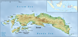
Seram is the largest and main island of Maluku province, despite Ambon Island's historical importance. It is located just north of the smaller Ambon Island and a few other adjacent islands, such as Saparua, Haruku, Nusa Laut and the Banda Islands.

Cilacap Regency is a regency in the southwestern part of Central Java province in Indonesia. Its capital is the town of Cilacap, which had 260,376 inhabitants in mid 2023, spread over three administrative districts.

Cilegon is a major coastal industrial city in Banten province, Indonesia, covering 162.51 km2 (62.75 sq mi). It is located on the island of Java. The city had a population of 374,464 at the 2010 Census and 434,896 at the 2020 Census; the official estimate as at mid 2023 was 470,378.

Pandeglang Regency is a regency of Banten province, Indonesia. It is mainly located on the west and south coasts of the island of Java and is the most westerly regency on Java Island, but it also includes several offshore islands such as Panaitan, Peucang, Deli and Tinjil. It is bounded by Serang Regency to the north, Lebak Regency to the east, the Java Sea to the south, and the Sunda Strait to the west. The regency has a land area of 3,053.13 km2, and a population at the 2010 Census of 1,149,610, rising to 1,272,687 at the 2020 Census; the official estimate as of mid-2023 was 1,391,056. The regency seat is the town of Pandeglang in the northeast of the regency, but the most densely-populated district outside of the northeast agglomeration is the town of Labuan on the west coast.
Sragen Regency is a regency in the eastern part of Central Java province in Indonesia. It covers an area of 994.57 km2 and had a population of 858,266 at the 2010 Census and 976,951 at the 2020 Census; the official estimate as at end 2023 was 1,011,206. Its capital is the town of Sragen, located about 30 km to the northeast of Surakarta. Sragen is bordered by East Java Province to the east.

West Sumba Regency is a regency in East Nusa Tenggara Province of Indonesia. Established in 1958, the regency was considerably reduced on 2 January 2007 with the creation of new Regencies on Sumba Island under Law UU No.16 of that year. Its area is now 721.96 km2, and its population was 110,993 at the 2010 census and 145,097 at the 2020 Census; the official estimate as at mid 2023 was 150,868. It has its seat (capital) in (Kota) Waikabubak.

East Kutai Regency is a regency of East Kalimantan province, Indonesia. It has an area of 31,239.84 km2 and had a population of 253,904 at the 2010 census and 434,459 at the 2020 census; the official estimate as at mid 2023 was 455,504. The town of Sangatta is the capital of the regency.
Kefamenanu is a town and capital of the administrative district (kecamatan) of Kota Kefamenanu and of the North Central Timor Regency in West Timor, Indonesia. A road connects it to Halilulik and Kota Atambua to the northeast. It had a population of 43,058 at the 2010 Census and 47,766 at the 2020 Census; the official estimate in mid 2023 was 47,628. The town hosts the University of Timor, one of the two public universities in the Indonesian part of the island.

Dompu is a town and the administrative centre of the Dompu Regency, located in the eastern part of the island of Sumbawa, in central Indonesia's province of West Nusa Tenggara. It is the third largest town on the island of Sumbawa, with a district population of 49,854 at the 2010 Census, which by the 2020 Census had grown to 54,987; the official estimate as at mid 2023 was 57,680. It is connected by provincial road to Bima and Sape.

Paser Regency is the southernmost regency within the East Kalimantan province of Indonesia. It was created in 26 June 1959 from the northern parts of Kotabaru. It was previously known as Pasir Regency until its renaming on 22 August 2007. Its northeastern districts were split off on 10 April 2002 to form the new Penajam North Paser Regency. The residual regency covers an area of 11,603.94 km2, and it had a population of 230,316 at the 2010 Census and 275,452 at the 2020 Census; the official estimate as at mid-2023 was 303,424. Its administrative centre is the town of Tana Paser.

The Banggai Archipelago is a group of islands located at the far eastern end of Central Sulawesi, Indonesia. It makes up a regency (kabupaten) of Central Sulawesi Province of Indonesia, created on 4 October 1999 by splitting the existing Banggai Regency into a residual Banggai Regency situated on the mainland of Sulawesi and a new Banggai Islands Regency then comprising the entire archipelago. On 14 December 2012 a splitting of the Banggai Islands archipelago took place with the removal of the more southerly seven districts from the 13-year-old regency to form a separate Banggai Laut Regency.

Tolitoli Regency is a regency of Central Sulawesi Province of Indonesia. It was previously part of a larger Buol Tolitoli Regency, but this was split into two on 4 October 1999 after rapid decentralization of the Indonesian government. The present Tolitoli Regency covers an area of 3,701.54 km2 and had a population of 211,296 at the 2010 Census and 225,154 at the 2020 Census; the official estimate as at mid 2023 was 231,711, comprising 118,180 male and 113,530 female inhabitants. Its regency seat is located at the town of Tolitoli, which is a port town and where the regency's population is concentrated.

Southeast Minahasa Regency is a regency in North Sulawesi, Indonesia. It covers a land area of 730.63 km2, and had a population of 100,443 at the 2010 Census; this had risen to 116,323 at the 2020 Census, and the official estimate as at mid 2023 was 118,946. It was established as a separate regency from the south-eastern part of the South Minahasa Regency on 2 January 2007. Its administrative centre is at the town of Ratahan.

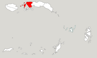
Central Maluku Regency is a regency of Maluku Province of Indonesia. The Regency covers an area of 11,595.57 km2, and had a population of 361,698 at the 2010 Census, and 423,094 at the 2020 Census. The official estimate as at mid 2023 was 430,798. The principal town lies at Masohi, on Seram Island. The regency (kebupaten) is composed of the central part of the island of Seram, the Banda Islands, and the Lease Islands, together with those parts of Ambon Island which are outside the City of Ambon.
West Seram Regency is a regency of Maluku, Indonesia. It is mainly located on Seram, but includes various islands lying to the west of Seram - the largest being Manipa, Kelang and Boano, as well as the smaller islets of Babi, Pua, Masowoi, and Marsegu. It covers a land area of 6,948.40 km2, and had a population of 164,654 at the 2010 Census and 212,393 at the 2020 Census; the official estimate as at mid 2023 was 214,979. The principal town lies at Piru, a port at the northern coast of Latira Bay which is a northwards extension of Piru Bay and almost separates the Huamual Peninsula from the rest of Seram Island. The western sector of the Regency occupies just under 25% of the land area, but held over 42% of the Regency's population at the 2020 Census.

Haruku Island is an island in Central Maluku Regency, Maluku Province, Indonesia - lying east of Ambon Island, off the southern coast of Seram and just west of Saparua. It is administered as a single district, Haruku Island District, with a land area of 150 km2 and a population of 24,207 at the 2010 census and 27,390 at the 2020 Census; the official estimate as at mid 2023 was 26,551. The inhabitants of Haruku speak the Haruku language, as well as Indonesian and Ambonese Malay.

Tigaraksa is a town and an administrative district (kecamatan) located in the Tangerang Regency of Banten Province on Java (island), Indonesia. The district covers a land area of 55.30 km2 and had 119,245 inhabitants in 2010 and 155,557 inhabitants in 2020; the official estimate as at mid 2023 was 163,531. The administrative headquarters of the Regency and of the district are located at the town of Tigaraksa.
Kairatu is a small town and district (kecamatan) on the southwestern coast of the island of Seram. It is part of West Seram Regency. According to the 2010 census, the district had a population of 54,866 people, but the district has subsequently been split and the reduced area had 27,040 inhabitants at the 2020 Census, while the official estimate as at mid 2023 was 26,717. The town itself had 10,266 inhabitants in mid 2022.
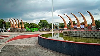
Amahai is a village (desa) and an administrative district (kecamatan) on the south coast of the island of Seram, in Central Maluku Regency. The village, which serves as the administrative centre of the eponymous district, lies to the south of Masohi town, both being situated on the coast of Elpaputih Bay, and they are surrounded on the landward sides by Amahai District. Teon Nila Serua District is also a semi-enclave within Amahai District, which surrounds it on all sides except the west. Daily speedboats connect Tulehu with Amahai, which is Seram's main port.
Namlea is a town and district (kecamatan) situated on the north side of Kayeli Bay on the northeastern coast of the Indonesian island of Buru. It is the capital of the Buru Regency.