
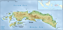
Seram is the largest and main island of Maluku province, despite Ambon Island's historical importance. It is located just north of the smaller Ambon Island and a few other adjacent islands, such as Saparua, Haruku, Nusa Laut and the Banda Islands.

Kelang Island is an island in West Seram Regency, Maluku Province, Indonesia. It is a mountainous island located off the western tip of Seram Island, just east of Manipa. Sole, located on the northeastern side, and Tahalupu on the western side are the two principal villages. Tonu Jaya is a third village in the southeast of the island. Mount Tonu, the highest point in the island, is an old volcano.

Maluku is a province of Indonesia. It comprises the central and southern regions of the Maluku Islands. The largest city and capital of Maluku province is Ambon on the small Ambon Island. It is directly adjacent to North Maluku, Southwest Papua, and West Papua in the north, Central Sulawesi, and Southeast Sulawesi in the west, Banda Sea, Australia, East Timor and East Nusa Tenggara in the south and Arafura Sea, Central Papua and South Papua in the east. The land area is 57803.81 km2, and the total population of this province at the 2010 census was 1,533,506 people, rising to 1,848,923 at the 2020 census, the official estimate as at mid 2023 was 1,908,753. Maluku is located in Eastern Indonesia.
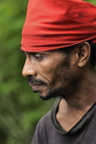
The Nuaulu, Naulu or Nunuhai are an ethnic group located in Seram, Maluku, Indonesia.
Scribd Inc. operates three primary platforms: Scribd, Everand, and SlideShare. Scribd is a digital document library that hosts over 195 million documents. Everand is a digital content subscription service offering a wide selection of ebooks, audiobooks, magazines, podcasts, and sheet music. SlideShare is an online platform featuring over 15 million presentations from subject matter experts.
The Central Maluku languages are a proposed subgroup of the Central–Eastern Malayo-Polynesian branch of the Austronesian language family which comprises around fifty languages spoken principally on the Seram, Buru, Ambon and the Sula Islands, Indonesia. None of the languages have as many as fifty thousand speakers, and several are extinct.

Manusela National Park is located on Seram island, in the Maluku. It is made up of coastal forest, swamp forest, lowland and montane rainforest ecosystem types. Mount Binaiya at 3,027 meters, is the highest of the park's six mountains. Seram is remarkable for its high degree of localised bird endemism. The park also includes important karst landscapes. On Mount Hatu Saka, near the coast of Saleman-Sawai, it is the Goa Hatusaka, currently the deepest cave of the whole Indonesia.
Tulehu is an Austronesian language spoken on Ambon Island in eastern Indonesia, part of a dialect chain of Seram Island.
Luhu was an Austronesian language spoken in the west of Seram Island in eastern Indonesia. It was spoken in Luhu village on Hoamoal Peninsula at the western end of Seram, and in Boano and Kelang islands, off the western tip of Seram Island.
Yalahatan is an Austronesian language spoken on Seram Island (Indonesia) in Yalahatan and Haruru villages, and hamlet of Awaiya in Tananahu village.

Manipa Island is an island in West Seram Regency, Maluku Province, Indonesia. It is located 8 km off the western coast of Kelang at the western end of Seram Island and 25 km off the western coast of Buru. Including adjacent small islands, it forms an administrative district (kecamatan) within the regency, with its district centre at Masawoi. The district covers an area of 159.71 km2 and had a population of 7,165 at the 2020 Census; the official estimate as at mid 2023 was 7,793.
Masiwang River is a river of eastern Seram Island, Maluku province, Indonesia, about 2700 km northeast of the capital Jakarta.
The Kawa River is a river of Seram Island, Maluku province, Indonesia, about 2500 km northeast of the capital Jakarta.
Sapalewa River, also Sapolewa, is a river of Seram Island, Maluku province, Indonesia, about 2400 km northeast of the capital Jakarta.
The Eti River is a river of Seram Island, Maluku province, Indonesia, about 2400 km northeast of the capital Jakarta. It flows into the sea on the southwest side of the island, a few kilometres south of the town of Piru, West Seram Regency.
The Tala River is a river of western Seram Island, Maluku province, Indonesia, about 2,400 km northeast of the capital Jakarta.
Salawai River is a river of Seram Island, Maluku province, Indonesia, about 2500 km northeast of the capital Jakarta.
Banggoi is a village on the northeastern coast of the island of Seram. The Bengoi language is spoken by some 350 people in Bengoi and surrounding areas.
Amahai is a village (desa) and an administrative district (kecamatan) on the south coast of the island of Seram, in Central Maluku Regency. The village, which serves as the administrative centre of the eponymous district, lies to the south of Masohi town, both being situated on the coast of Elpaputih Bay, and they are surrounded on the landward sides by Amahai District. Teon Nila Serua District is also a semi-enclave within Amahai District, which surrounds it on all sides except the west. Daily speedboats connect Tulehu with Amahai, which is Seram's main port.
Atiahu is a village (negeri) in Siwalalat District, East Seram Regency, Maluku. This village is located at a river estuary in Telutih Bay, just north of Bemu. This is a fishing village. The Bobot language is spoken by the people of Atiahu and several surrounding villages.