Niwelehu

Last updated
Niwelehu
Village
Niwelehu.jpg
The entrance of Niwelehu
Indonesia location map.svg
Red pog.svg
Location in Indonesia
Indonesia Maluku location map.svg
Red pog.svg
Location in the Maluku Islands
Seram en.png
Red pog.svg
Location in Seram Island
Coordinates: 2°52′S128°23′E / 2.867°S 128.383°E / -2.867; 128.383
CountryIndonesia
Province Maluku
Regency West Seram
Ministry of Home Affairs code81.06.03.2003
[1]

Niwelehu is a small village located in the northern part of Taniwel, a district of the Indonesian island of Seram.

Contents

Politics

Political System

The current Raja, Boys Rotasouw Bapa Raja.jpg
The current Raja, Boys Rotasouw

The highest ranked political figure in the Niwelehu village government is the Raja, which is Bahasa Indonesia for ‘king’. Because of this, Niwelehu technically operates under a monarchic political system. However, the king is still elected by the people and there is a village government. The current Raja is Boys Rotasouw. He has been in power since 2013.[ when? ]

Because of the historical past of the village, only people with the last name Rotasouw or Latumakulita are eligible to be Raja. The Raja position is also open to women. The first Raja, Arleka Rotasouw, ruled during the colonization by the Portuguese in the 1800s. Layin Patty Rotasouw was the first Raja after the independence of the Maluku Islands.

History of Rajas
NoMandateName
1Under Portuguese ColonyArleka Rotasouw
2Under Netherlands ColonyPiata Rotasouw
31901–1930Layin Patty Rotasouw
41930–1945Arnold Rotasouw
51955–1992Cosmus Rotasouw
61993–2003Hendrik Rotasouw
72003–2012Arnold Latumakulita
82013 - nowBoys Rotasouw

Village Government

The king of Niwelehu is the most important political figure in the village. However, there are village institutions that allow the government to be balanced. As of 2017, there are ten village government institutions that vary from the parliament to women entrepreneurship and youth. At the head of every village institution, there is a responsible who represents the institution at the village parliament. The ten institutions are: Village parliament; Women and family empowerment institution; Youth Institution; Farmer Institution; Fisherman Institution; Art Institution; Health Care Management Institution; Economic Enterprise Institution; Community Empowerment Management Institution; and the Women Entrepreneurship Institution.

Religion

The Church of Niwelehu The Church of Niwelehu.jpg
The Church of Niwelehu

When it comes to religion, Niwelehu villagers believed in animism until the year 1901. Nature is a very important part of Maluku culture. However, in the 20th century, Christianity became the dominant religion in the village. Historically, there have been many religious wars in the Maluku Islands. For this reason, the Muslim villagers of Niwelehu live in a neighbouring village, Wee village. Nowadays, relationship between Christians and Muslims in Niwelehu is very friendly and they accept and co-live with each other.

Niwelehu is a Protestant village. Religion is a very important part of the culture. After the King, one of the most important and influential figures of the village is the pastor.

Geography

Niwelehu is at the north-west of West-Seram Island, which is one of the main islands of the famous Maluku Islands, also known as the Spice Islands. The territory of the village is 101.15 km2. This figure includes the surrounding forest that villagers use for farming. The village itself is very small and only contains 69 houses.

Niwelehu is part of the sub-district of Taniwel which is located in the North Seram District. The village is 12 km from Taniwel and 60 km away from Piru, which is the capital city of West Seram. At the north of Niwelehu is the Seram Sea, which is connected to the Pacific Ocean. South of Niwelehu, there is the West Seram Jungle. West of Niwelehu is the Nikulukan village, which is a Christian village. Finally, east of Niwelehu there is the Nuniali village. The 'Muslim' Niwelehu village, Wee, is located around 5 kilometres from Niwelehu. It is nicknamed that way because it is populated with people from the same history as Niwelehu, who decided to follow the Muslim faith.

Natural features

A view of Tona Waterfall A view of Tona Waterfall.jpg
A view of Tona Waterfall

Tona waterfall: 30-meter waterfall. A popular swimming spot for children.

Wairera waterfall: 15-meter waterfall reached by walking through the river, small villages and the forest; it also has caves.

Tomarala beach: beach on the Seram Sea popular for swimming. The village company, Tomarala Sun, is named after it.

Wee beach: a more private beach than Tomarala, with rocks and corals in the water. From time to time, dolphins can be seen jumping here.

Economy and Infrastructure

The economical system in Niwelehu is still based on bartering, although money is also used. With 80% of the working population working as farmers or fishermen, agribusiness is the main source of income for the village.

System of Agribusiness

The agribusiness system in Niwelehu is separated into three types of commodities that allow harvests all year round. All the fishing is done in the Seram Sea north of Niwelehu, while all the farming is done in the forest south of Niwelehu. The first part of the agribusiness is based on agriculture of chilis, cassava plants and other plants. The second commodity is based on gardening of other crops such as mangoes, coconuts, coffee, cocoa, durian, cloves, and nutmeg. Finally, the farmers also gather products from the forest, such as wood, sago and kenaris (pili nuts). The villagers practice crop rotation.

The harvested crops are exchanged between villagers or sold to businessmen who come bi-monthly to buy the harvest and re-sell for profit in Piru or Ambon.

Government Funding

The provincial government of Maluku and the federal government based in Jakarta finance every village depending on the size, population, and development needs. According to the medium-term village development programs, Niwelehu is set to receive 5,837,500,000 billion IDR (around 450,000 US $) between 2015 and 2019. The money is divided into categories, some of the main ones being health, education, social-cultural and agriculture.

Government Funding for Niwelehu between 2015 and 2019
NoDepartmentTotal Amount
1HealthIDR37,500,000
2EducationIDR1,600,000,000
3FacilitiesIDR3,000,000,000
4Village GovernmentIDR225,000,000
5Economic EnterpriseIDR155,000,000
6FisheryIDR260,000,000
7Socio-CulturalIDR170,000,000
8Animal HusbandryIDR160,000,000
9AgricultureIDR230,000,000

Niwelehu depends on government funding in order to develop the infrastructure of the village. Villagers are not legally obligated to pay taxes to the government, as annual incomes are deemed too low.

Village Infrastructures

In comparison to the neighbouring villages of Niwelehu such as Nikulukan and Nuniali, Niwelehu has more developed infrastructure, including a primary school, clean water pipes, and even volleyball and football field. The construction and maintenance of this infrastructure is made possible by yearly government funding. However, there are still some key things missing or broken, namely a health centre or a clinic, a village office and a clean water well.

Demographics

In the summer of 2017, a village census was conducted, house by house, by the Wonderful Niwelehu team, which is part of the Wonderful Maluku Project, a global entrepreneur program based on an AIESEC Indonesia collaboration with the Citra Kasih Abadi Foundation.

Population

There are 69 houses in Niwelehu. Some houses host two or even three families, with the house populations being as many as 13 people. The average population per house is 6.3. In total, 433 people live in Niwelehu. Some 54% of the population, so 234 people, are men. The women in the village form 46% of the population (199 people).

Age Groups

In order to conduct the survey, the age groups were divided into three groups: the children: 0-13 year olds, the teens: 14–19 years olds, and the adults: 20 and above. The census showed that 27% of the population are between the ages of 0 and 13. The 14 to 19 year-old teens formed 13% of the population, while the 20 and above made up the majority of the population, with 59%.

Education

There are 157 people in the village who are currently enrolled into a school institution. 89% of people aged 0 to 19 are in school and only 20 children are not in school. From the survey, the Wonderful Niwelehu team has found that a majority of those 20 children are not of age to go to school.

Work

51% of the village population is employed, while 36% are in school. The most popular job in Niwelehu is farmer/fishermen, with 175 people, men and women, working in either jobs. The remaining 20% of the working population are employed as teachers, factory workers, housewives and more.

Culture

The Niwelehu culture is very community based. Because of the small size of the village, all the villagers are very close. Village activities usually revolve around sports, as it is a big part of the culture. Volleyball, football (soccer), and badminton are the most popular sports in the village and they are played everyday on the beach or at the fields.

When it comes to food, the fishing and farming culture makes it very easy and healthy. Most produce that is harvested is cooked for family meals. The main sources of protein are fish and tofu. In addition, all meals usually have rice, sagu or noodles.

As stated in the religion section, the Niwelehu villagers are very observant. Sunday church is a family activity that almost everyone attends, with the exception of people who are farming, working or children who are too young.

Wonderful Niwelehu Wonderful Niwelehu.jpg
Wonderful Niwelehu

Wonderful Niwelehu

Based in Niwelehu, the Wonderful Niwelehu team is part of the 2017 Wonderful Maluku Project, a global entrepreneur program based on an AIESEC Indonesia collaboration with the Citra Kasih Abadi Foundation. The vision of the Niwelehu team was to empower potential entrepreneurs to create sustainable solutions for long-term social and economic development through urban development and media exposure in the Maluku tourism sector. The team was made up of nine international students and one project coordinator from Canada, France, Germany, Malta, Morocco, South Africa and Indonesia.

During their three-month stay in Niwelehu, the team worked on business development, project innovation, marketing and communication and journalism. A village brand, Tomarala Sun, was created by the Wonderful Niwelehu team. The team also worked on waste management and compost plans, while making partnerships with businesses.

Related Research Articles

<span class="mw-page-title-main">Maluku Islands</span> Archipelago in eastern Indonesia

The Maluku Islands or the Moluccas are an archipelago in the eastern part of Indonesia. Tectonically they are located on the Halmahera Plate within the Molucca Sea Collision Zone. Geographically they are located east of Sulawesi, west of New Guinea, and north and east of Timor. Lying within Wallacea, the Moluccas have been considered a geographical and cultural intersection of Asia and Oceania.

<span class="mw-page-title-main">Ambon Island</span> One of the Maluku Islands in Indonesia

Ambon Island is part of the Maluku Islands of Indonesia. The island has an area of 743.37 km2 (287.02 sq mi) and is mountainous, well watered, and fertile. Ambon Island consists of two territories: the city of Ambon to the south and various districts (kecamatan) of the Central Maluku Regency to the north. The main city and seaport is Ambon, which is also the capital of Maluku province, while those districts of Maluku Tengah Regency situated on Ambon Island had a 2020 Census population of 128,069. Ambon has an airport and is home to the Pattimura University and Open University, state universities, and a few private universities, which include Darussalam University and Universitas Kristen Indonesia Maluku (UKIM).

<span class="mw-page-title-main">North Maluku</span> Province of Indonesia

North Maluku is a province of Indonesia. It covers the northern part of the Maluku Islands, bordering the Pacific Ocean to the north, the Halmahera Sea to the east, the Molucca Sea to the west, and the Seram Sea to the south. It shares maritime borders with North Sulawesi, Southeast Sulawesi and Central Sulawesi to the west, Maluku to the south, Southwest Papua to the west, and Palau and the Philippines to the north. The provincial capital is Sofifi on the largest island of Halmahera, while the largest city is the island city of Ternate. The population of North Maluku was 1,038,087 in the 2010 census, making it one of the least-populous provinces in Indonesia, but by the 2020 Census the population had risen to 1,282,937, and the official estimate as at mid 2022 was 1,319,338.

<span class="mw-page-title-main">West Nusa Tenggara</span> Province of Indonesia

West Nusa Tenggara is a province of Indonesia. It comprises the western portion of the Lesser Sunda Islands, with the exception of Bali which is its own province. Mataram, on Lombok, is the capital and largest city of the province. It shares maritime borders with Bali to the west and East Nusa Tenggara to the east. The 2010 census recorded the population at 4,500,212; the total rose to 4,830,118 at the 2015 Intermediate Census and 5,320,092 at the 2020 census; the official estimate as at mid 2022 was 5,473,671. The province's area is 20,153.15 km2. The two largest islands by far in the province are Lombok in the west and the larger Sumbawa island in the east.

<span class="mw-page-title-main">Seram Island</span> Main island of Maluku Province, Indonesia

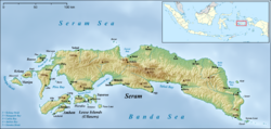
Seram is the largest and main island of Maluku province of Indonesia, despite Ambon Island's historical importance. It is located just north of the smaller Ambon Island and a few other adjacent islands, such as Saparua, Haruku, Nusa Laut and the Banda Islands.

<span class="mw-page-title-main">Kai Islands</span> Island group of Indonesia

The Kai Islands of Indonesia are a group of islands in the southeastern part of the Maluku Islands, located in the province of Maluku. The Moluccas have been known as the Spice Islands due to regionally specific plants such as nutmeg, mace, and cloves that originally intrigued the European nations of the 16th century.

<span class="mw-page-title-main">Buru</span> Island in Maluku, Indonesia

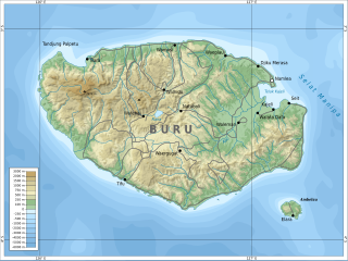
Buru is the third largest island within the Maluku Islands of Indonesia. It lies between the Banda Sea to the south and Seram Sea to the north, west of Ambon and Seram islands. The island belongs to Maluku province and includes the Buru and South Buru regencies. Their administrative centers, Namlea and Namrole, respectively, have ports and are the largest towns of the island, served by Namlea Airport and Namrole Airport respectively.

<span class="mw-page-title-main">Maluku (province)</span> Province of Indonesia

Maluku is a province of Indonesia. It comprises the central and southern regions of the Maluku Islands. The largest city and capital of Maluku province is Ambon on the small Ambon Island. It is directly adjacent to North Maluku, Southwest Papua, and West Papua in the north, Central Sulawesi, and Southeast Sulawesi in the west, Banda Sea, Australia, East Timor and East Nusa Tenggara in the south and Arafura Sea, Central Papua and South Papua in the east. The land area is 46,150.92 km2, and the total population of this province at the 2010 census was 1,533,506 people, rising to 1,848,923 at the 2020 census, the official estimate as at mid 2022 was 1,881,727. Maluku is located in Eastern Indonesia.

<span class="mw-page-title-main">Republic of South Maluku</span> Former country

South Maluku, also South Moluccas, officially the Republic of South Maluku, is an unrecognised secessionist republic that originally claimed the islands of Ambon, Buru, and Seram, which currently make up the Indonesian province of Maluku.

<span class="mw-page-title-main">Ternate</span> City in North Maluku, Indonesia

Ternate, also known as the City of Ternate, is a city in the Indonesian province of North Maluku and an island in the Maluku Islands. It was the de facto provincial capital of North Maluku before Sofifi on the nearby coast of Halmahera became the capital in 2010. It is off the west coast of Halmahera, and is composed of eight islands: Ternate, the biggest and main island of the city, and Moti, Hiri, Tifure, Mayau, Makka, Mano, and Gurida. In total, the city has a land area of 162.17 square kilometres and had a total population of 185,705 according to the 2010 census, and 205,001 according to the 2020 census, with a density of 1,264 people per square kilometre; the official estimate as at mid 2022 was 206,745. It is the biggest and most densely populated city in the province, is the economic, cultural, and education center of North Maluku, and acts as a hub to neighbouring regions. It was the capital of the Sultanate of Ternate in the 15th and 16th centuries, and fought against the Sultanate of Tidore over control of the spice trade in the Moluccas before becoming a main interest to competing European powers.

<span class="mw-page-title-main">Tobelo</span> Town in North Maluku, Indonesia

Tobelo is a town and a district on the eastern Indonesian island of Halmahera. It is the capital of the regency (kabupaten) of North Halmahera, part of the province of North Maluku. The town was formalised as the capital of North Halmahera in the district elections held in 2004. It had a population of 34,150 at the 2020 Census. A palm tree lined coastal road connects Tobelo to Galela. The town is predominantly Muslim with a large Christian minority and a Protestant Church has existed in Tobelo since at least 1924.

<span class="mw-page-title-main">Raja Ampat Islands</span> Archipelago in Southwest Papua, Indonesia

Raja Ampat, or the Four Kings, is an archipelago located off the northwest tip of Bird's Head Peninsula on the island of New Guinea, in Indonesia's Southwest Papua province. It comprises over 1,500 small islands, cays, and shoals surrounding the four main islands of Misool, Salawati, Batanta, and Waigeo, and the smaller island of Kofiau.

<span class="mw-page-title-main">Alune people</span> Ethnic group of Seram Island, Indonesia

The Alune people are one of the long-established ethnic groups of Seram Island, Indonesia. They number about 21,300 and live in 27 villages of the western-central area of the island. Like the Wemale, they originated in a common group called Patasiwa.

<span class="mw-page-title-main">North Halmahera Regency</span> Regency in North Maluku, Indonesia

North Halmahera Regency is a regency of North Maluku Province, Indonesia. It was declared a separate Regency on 31 May 2003, formed from part of the former North Maluku Regency. The capital town of the regency lies at the port of Tobelo. The Regency, which has been considerably reduced by the separation of Morotai Island in 2008, now covers an area of 3,891.62 square kilometres (1,502.56 sq mi) and had a population of 161,847 people at the 2010 Census, 179,783 at the 2015 Intermediate Census. and 197,640 at the 2020 Census. The official estimate as at mid 2022 was 202,755. The principal settlements are Tobelo, Kao and Galela. The area is noted for its white beaches and coral reefs.

<span class="mw-page-title-main">Lisela people</span> Ethnic group of Indonesia

Lisela or Rana people is an ethnic group mostly living on Indonesian island Buru, as well as on some other Maluku Islands. They belong to the eastern Indonesian anthropological group and are sometimes referred to as northern Buru people. From an ethnographic point of view, Lisela are similar to other indigenous peoples of Buru island. They speak the Lisela language.

<span class="mw-page-title-main">Kayeli people</span>

Kayeli people is an ethnic group mainly living on the southern coast of the Kayeli Gulf of Indonesian island Buru, mainly from the Kaiely Gulf. From an ethnographic point of view, Kayeli are close to other indigenous people of Buru, such as Lisela and Buru.

<span class="mw-page-title-main">Maluku sectarian conflict</span> Religious conflict in Indonesia

The Maluku Islands sectarian conflict was a period of ethno-political conflict along religious lines, which spanned the Indonesian islands that compose the Maluku archipelago, with particularly serious disturbances in Ambon and Halmahera islands. The duration of the conflict is generally dated from the start of the Reformasi era in early 1999 to the signing of the Malino II Accord on 13 February 2002.

<span class="mw-page-title-main">Raja Ampat Regency</span> Regency in Southwest Papua, Indonesia

Raja Ampat Regency is a regency of Southwest Papua Province of Indonesia. The regency, which was formed by separating the archipelago from Sorong Regency, based on the Law 26 of 2002, was inaugurated on 12 April 2003. It consists of a number of groups of islands situated off the north-west end of West Papua; the four main islands from south to north are Misool, Salawati, Batanta, and Waigeo. At present, the regency covers a land area of 7,559.60 km2, with a total area stated as 67,379.61 km2. It had a population of 42,508 at the 2010 Census and 64,141 at the 2020 Census; the official estimate as at mid 2022 was 66,839. The principal town lies at Waisai on Waigeo Island.
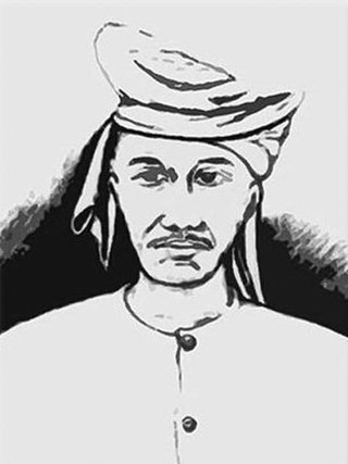
<span class="mw-page-title-main">Sangirese people</span> Native people to the Sangir Islands

Sangirese or Sangihe people are one of the native people to the Sangir Islands in the northern chain of islands in Sulawesi and the southern part of Mindanao. The Sangirese people are fishermen and nutmeg growers in their home areas and also work as wage labourers in industrial crops enterprises in Bolaang Mongondow Regency and Minahasa Regency.

<span class="mw-page-title-main">Tobelo people</span>

The Tobelo people are one of the northern Halmahera peoples living in eastern Indonesia, in the northern part of the Maluku Islands and in the eastern side of North Halmahera Regency.

References

  1. Keputusan Menteri Dalam Negeri Nomor 100.1.1-6117 Tahun 2022 (Commons-logo.svg  File on Commons) (in Indonesian), Ministry of Home Affairs, p. 3407