Ambon Island is part of the Maluku Islands. The island has an area of 743.37 km2 (287.02 sq mi) and is mountainous, well watered, and fertile. Ambon Island consists of two territories: the city of Ambon to the south, and three districts (kecamatan) of the Central Maluku Regency to the north. The main city and seaport is Ambon, which is also the capital of Maluku province, while those districts of Maluku Tengah Regency situated on Ambon Island had a 2020 Census population of 128,069. By mid 2023 those populations were estimated to have become 354,052 and 128,754 respectively, resulting in an all-island population of 482,806.

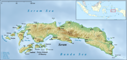
Seram is the largest and main island of Maluku province, despite Ambon Island's historical importance. It is located just north of the smaller Ambon Island and a few other adjacent islands, such as Saparua, Haruku, Nusa Laut and the Banda Islands.

Saparua is an island east of Ambon Island in the Indonesian province of Maluku; the island of Haruku lies between Saparua and Ambon. The main port is in the south at Kota Saparua. The small and uninhabited island of Maolana is located near its southwestern side and Nusa Laut off its southeastern tip.

Ambon is the capital and largest city of the Indonesian province of Maluku. This city is also known as Ambon Manise, which means "beautiful" or "pretty" Ambon in the Ambonese language. It covers a land area of 359.45 km2, and had a population of 331,254 at the 2010 Census and 347,288 at the 2020 Census; the official estimate as at mid 2023 was 354,052. The city is divided into five administrative districts – namely Nusaniwe, Sirimau, Teluk Ambon, Baguala and Leitimur Selatan. Known as Indonesia's music city, Ambon became the first city in Southeast Asia to be recognised as the UNESCO City of Music in 2019.

Maluku is a province of Indonesia. It comprises the central and southern regions of the Maluku Islands. The largest city and capital of Maluku province is Ambon on the small Ambon Island. It is directly adjacent to North Maluku, Southwest Papua, and West Papua in the north, Central Sulawesi, and Southeast Sulawesi in the west, Banda Sea, Australia, East Timor and East Nusa Tenggara in the south and Arafura Sea, Central Papua and South Papua in the east. The land area is 57803.81 km2, and the total population of this province at the 2010 census was 1,533,506 people, rising to 1,848,923 at the 2020 census, the official estimate as at mid 2023 was 1,908,753. Maluku is located in Eastern Indonesia.

Wetar is a tropical island which belongs to the Indonesian province of Maluku and is the largest island of the Maluku Barat Daya Islands Regency of the Maluku Islands. It lies east of the Lesser Sunda Islands, which include nearby Alor and Timor, but it is politically part of the Maluku Islands. To the south, across the Wetar Strait, lies the island of Timor; at its closest it is 50 km away. To the west, across the Ombai Strait, lies the island of Alor. To the southwest is the very small island of Liran, which is also part of West Wetar District and, further southwest, the small East Timorese island of Atauro. To the north is the Banda Sea and to the east lie Romang and Damar Islands, while to the southeast lie the other principal islands of the Barat Daya Islands. Including Liran and other small offshore islands, Wetar has an area of 2,651.8 km2, and had a population of 7,916 at the 2010 Census and 8,622 at the 2020 Census; the official estimate as at mid 2023 was 11,109. Administratively, Wetar is divided into four of the districts (kecamatan) of the Maluku Barat Daya Regency.

West Halmahera Regency is a regency in North Maluku Province of Indonesia. The regency was created on 25 February 2003 from the western districts of the former North Maluku Regency, and is now bounded by North Halmahera Regency to the north and east, while to the south it borders both East Halmahera Regency and that portion of the city of Tidore on the mainland of Halmahera. It covers an area of 2,239.11 km2, and it had a population of 100,424 people at the 2010 Census and 132,349 at the 2020 Census; the official estimate as at mid 2023 was 137,543. The capital lies at Jailolo (town).

Central Halmahera Regency is a regency of North Maluku Province, Indonesia. The regency was originally formed on 15 August 1990 from part of the former North Maluku Regency, but on 25 February 2003 parts of the new regency were split off to form a separate East Halmahera Regency and the city of Kota Tidore Kepulauan. It now comprises just the southern half of the southeastern peninsula of Halmahera Island, together with part of the southern peninsula of that island.

Poso Regency is a regency of Central Sulawesi Province of Indonesia. It covers an area of 7,438.55 km2, and had a population of 209,228 at the 2010 Census and 244,875 at the 2020 Census; the official estimate as at mid 2023 was 251,654. The principal town lies at Poso.

Central Maluku Regency is a regency of Maluku Province of Indonesia. The Regency covers an area of 11,595.57 km2, and had a population of 361,698 at the 2010 Census, and 423,094 at the 2020 Census. The official estimate as at mid 2023 was 430,798. The principal town lies at Masohi, on Seram Island. The regency (kebupaten) is composed of the central part of the island of Seram, the Banda Islands, and the Lease Islands, together with those parts of Ambon Island which are outside the City of Ambon.

Tanimbar Islands Regency is a regency of Maluku province, Indonesia, consisting primarily of the Tanimbar Islands. The Regency covers a land area of 10,102 km2, and it had a population of 105,341 at the 2010 Census and 123,572 at the 2020 Census; the official estimate as at mid 2022 was 124,787. The principal town and administrative centre lies at Saumlaki in Tanimbar Selatan District.

Raja Ampat Regency is a regency of Southwest Papua Province of Indonesia. The regency, which was formed by separating the archipelago from Sorong Regency, based on the Law 26 of 2002, was inaugurated on 12 April 2003. It consists of a number of groups of islands situated off the north-west end of West Papua; the four main islands from south to north are Misool, Salawati, Batanta, and Waigeo. At present, the regency covers a land area of 7,559.60 km2, with a total area stated as 67,379.61 km2. It had a population of 42,508 at the 2010 Census and 64,141 at the 2020 Census; the official estimate as at mid 2023 was 68,501. The principal town lies at Waisai on Waigeo Island.
East Seram Regency is a regency of Maluku (province), in Indonesia. It is mainly located on the island of Seram, but also includes smaller islands to the southeast comprising the Gorom and Watubela archipelagoes. The regency covers a land area of 5,779.12 km2, and had a population of 99,065 at the 2010 Census and 137,972 at the 2020 Census; the official estimate as at mid 2023 was 138,580. The principal town lies at Bula, on Seram Island.

Haruku Island is an island in Central Maluku Regency, Maluku Province, Indonesia - lying east of Ambon Island, off the southern coast of Seram and just west of Saparua. It is administered as a single district, Haruku Island District, with a land area of 150 km2 and a population of 24,207 at the 2010 census and 27,390 at the 2020 Census; the official estimate as at mid 2023 was 26,551. The inhabitants of Haruku speak the Haruku language, as well as Indonesian and Ambonese Malay.

Nusa Laut is the smallest of the three inhabited island in the Lease Islands group situated east of Ambon Island, in Indonesia's Maluku province. It lies just off the south-western corner of Saparua island, separated from it by a deep channel. The island's coasts are fringed by a drying reef.
The Lease Islands, formerly called the Uliasers or Uliassers, are a group of three inhabited islands, lying immediately to the south of Seram and east of Ambon Island in the province of Maluku, in Indonesia. The three inhabited islands, from west to east, are Haruku, Saparua and Nusa Laut, while tiny uninhabited Molana is administratively part of Saparua District; these islands constitute four administrative districts (kecamatan) within Central Maluku Regency.
Boano Island is an island in West Seram Regency, Maluku Province, Indonesia. It is located off the northern coast of the Hoamoal Peninsula at the western end of Seram Island, across the Boano Strait. The inhabitants speak the Boano and Luhu languages, as well as Indonesian and Ambonese Malay.
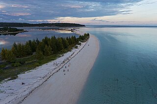
Amahai is a village (desa) and an administrative district (kecamatan) on the south coast of the island of Seram, in Central Maluku Regency. The village, which serves as the administrative centre of the eponymous district, lies to the south of Masohi town, both being situated on the coast of Elpaputih Bay, and they are surrounded on the landward sides by Amahai District. Teon Nila Serua District is also a semi-enclave within Amahai District, which surrounds it on all sides except the west. Daily speedboats connect Tulehu with Amahai, which is Seram's main port.