
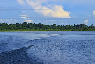
Saparua is an island east of Ambon Island in the Indonesian province of Maluku; the island of Haruku lies between Saparua and Ambon. The main port is in the south at Kota Saparua. The small and uninhabited island of Maolana is located near its southwestern side and Nusa Laut off its southeastern tip.

The Barat Daya Islands are a group of islands in the Maluku province of Indonesia. The Indonesian phrase barat daya means 'south-west'.

Anambas Islands Regency is a small archipelago of Indonesia, located 150 nautical miles northeast of Batam Island in the North Natuna Sea between the Malaysian mainland to the west and the island of Borneo to the east. Geographically part of the Tudjuh Archipelago, it is administratively a regency within the Riau Islands Province. It covers a land area of 590.14 square kilometres (227.85 sq mi) and had a population of 37,411 at the 2010 Census and 47,402 at the 2020 Census; the official estimate as at mid 2023 was 49,090. The administrative centre is at Tarempa on Siantan Island.

North Tapanuli Regency is a landlocked regency in North Sumatra province, Sumatra, Indonesia. Its capital is Tarutung. The regency covers an area of 3,793.71 square kilometres and it had a population of 278,897 at the 2010 Census and 312,758 at the 2020 Census; the official estimate as of mid-2023 was 323,102.
Mamberamo Raya Regency or Greater Mamberamo Regency is one of the regencies (kabupaten) in Papua Province, Indonesia; it was created on 15 March 2007 from parts of Sarmi Regency and Waropen Regency. The regency gets its name from the Mamberamo river. The largest regency by land in Papua province, It covers an area of 23,813.91 km2, and had a population of 18,365 at the 2010 Census which had almost doubled to 36,483 at the 2020 Census; the official estimate as at mid 2023 was 38,636. The administrative centre is at the town of Burmeso in Mamberamo Tengah District.

Pinrang Regency is one of the twenty-one regencies in South Sulawesi Province of Indonesia. Pinrang town in Watang Sawitto District is the administrative capital of Pinrang Regency. The regency is situated in the northwest of the South Sulawesi peninsula, and covers a land area of 1,896.57 km2. It had a population of 351,161 at the 2010 Census and 403,994 at the 2020 Census; the official estimate as at mid 2023 was 417,932.

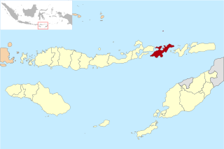
Sumbawa Regency is a Regency (Kabupaten) of the Indonesian Province of West Nusa Tenggara. It is located on the island of Sumbawa and covers an area of 6,643.99 km2, following the separation on 18 December 2003 of what were until then its westernmost five districts to form the newly created West Sumbawa Regency. It includes the substantial island of Moyo, lying off the north coast of Sumbawa. The population of the Regency at the 2010 Census was 415,789, which rose at the 2020 Census to 509,753; the official estimate as at mid 2023 was 529,487. The capital is the town of Sumbawa Besar on the north coast of Sumbawa Island.

West Sumbawa Regency is a Regency (Kabupaten) of the Indonesian Province of West Nusa Tenggara. It is located on the island of Sumbawa and has an area of 1,743.58 km2. The regency was created on 18 December 2003 from what were at that time the westernmost five districts (kecamatan) of Sumbawa Regency. The population at the 2010 Census was 114,754, and at the 2020 Census was 145,798; the official estimate as at mid 2023 was 152,950 comprising 77,030 males and 75,920 females. The capital is the town of Taliwang.
Lembata Regency is a regency in East Nusa Tenggara province of Indonesia. Established on 4 October 1999 from the most easterly part of East Flores Regency, the regency covers the island of Lembata, together with three small offshore islands together forming the eastern part of the Solor Archipelago, and has its administrative seat (capital) in Lewoleba. The population of the Regency was 117,829 at the 2010 decennial census and at the 2020 census was 135,930; the official estimate as at mid 2023 was 141,391 - comprising 68,409 males and 72,982 females.

Dompu is a town and the administrative centre of the Dompu Regency, located in the eastern part of the island of Sumbawa, in central Indonesia's province of West Nusa Tenggara. It is the third largest town on the island of Sumbawa, with a district population of 49,854 at the 2010 Census, which by the 2020 Census had grown to 54,987; the official estimate as at mid 2023 was 57,680. It is connected by provincial road to Bima and Sape.
West Halmahera Regency is a regency in North Maluku Province of Indonesia. The regency was created on 25 February 2003 from the western districts of the former North Maluku Regency, and is now bounded by North Halmahera Regency to the north and east, while to the south it borders both East Halmahera Regency and that portion of the city of Tidore on the mainland of Halmahera. It covers an area of 2,239.11 km2, and it had a population of 100,424 people at the 2010 Census and 132,349 at the 2020 Census; the official estimate as at mid 2023 was 137,543. The capital lies at Jailolo (town).
Central Halmahera Regency is a regency of North Maluku Province, Indonesia. The regency was originally formed on 15 August 1990 from part of the former North Maluku Regency, but on 25 February 2003 parts of the new regency were split off to form a separate East Halmahera Regency and the city of Kota Tidore Kepulauan. It now comprises just the southern half of the southeastern peninsula of Halmahera Island, together with part of the southern peninsula of that island.

Sabu Raijua Regency is one of the regencies in the province of East Nusa Tenggara, Indonesia. This regency has an area of 459.58 km2 which includes two main islands in the Sawu Sea, namely Sabu Island and Raijua Island. Sabu Island is the largest and is the center of government with its capital in West Sabu district, while Raijua Island is smaller and located to the west of Sabu Island. The regency was established by Indonesia's Minister of Home Affairs, Mardiyanto, on 29 October 2008, when it was partitioned from Kupang Regency. The population was 72,960 at the 2010 census, and 89,327 at the 2020 Census; the official estimate as at mid 2023 was 93,330.

East Tanjung Jabung Regency is a regency of Jambi Province, Indonesia. It is located on the island of Sumatra. The regency was created on 4 October 1999 by the division of the then Tanjung Jabung Regency into eastern and western halves. It now has an area of 5,087.07 km2 and had a population of 205,272 at the 2010 census and 229,813 at the 2020 census; the official estimate as at mid 2023 was 236,727. The regency's administrative capital lies at the town of Muara Sabak, a riverine port near the mouth of the Berbak River.
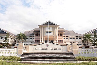
Tojo Una-Una Regency is a regency of Central Sulawesi, Indonesia. The administrative centre is at Ampana town, on the Sulawesi 'mainland'. While the Regency includes a considerable area on the eastern peninsula of Sulawesi, it also includes the Togian Islands in the Gulf of Tomini. The total area covers 5,721.51 km2 and the population was 134,945 at the 2010 Census and 163,829 at the 2020 Census; the official estimate as at mid 2023 was 169,002.

Buru Regency is a regency of Maluku province, Indonesia. When it was first created on 4 October 1999, the regency encompassed the entire island ; but on 24 June 2008 the southern 40% of the island was split off to form a separate Buru Selatan Regency. The residual Buru Regency comprises the northern 60% of the island of Buru and covers an area of 7,595.58 km2. The population at the 2010 census was 108,445 and at the 2020 census this had increased to 135,238; the official estimate as at mid 2023 was 139,408. The principal town lies at Namlea.

Central Maluku Regency is a regency of Maluku Province of Indonesia. The Regency covers an area of 11,595.57 km2, and had a population of 361,698 at the 2010 Census, and 423,094 at the 2020 Census. The official estimate as at mid 2023 was 430,798. The principal town lies at Masohi, on Seram Island. The regency (kebupaten) is composed of the central part of the island of Seram, the Banda Islands, and the Lease Islands, together with those parts of Ambon Island which are outside the City of Ambon.

Haruku Island is an island in Central Maluku Regency, Maluku Province, Indonesia - lying east of Ambon Island, off the southern coast of Seram and just west of Saparua. It is administered as a single district, Haruku Island District, with a land area of 150 km2 and a population of 24,207 at the 2010 census and 27,390 at the 2020 Census; the official estimate as at mid 2023 was 26,551. The inhabitants of Haruku speak the Haruku language, as well as Indonesian and Ambonese Malay.

The Lease Islands, formerly called the Uliasers or Uliassers, are a group of three inhabited islands, lying immediately to the south of Seram and east of Ambon Island in the province of Maluku, in Indonesia. The three inhabited islands, from west to east, are Haruku, Saparua and Nusa Laut, while tiny uninhabited Molana is administratively part of Saparua District; these islands constitute four administrative districts (kecamatan) within Central Maluku Regency.
Amahai is a village (desa) and an administrative district (kecamatan) on the south coast of the Indonesian island of Seram, in Central Maluku Regency. The village, which serves as the administrative centre of the eponymous district, lies to the south of Masohi town, both being situated on the coast of Elpaputih Bay, and they are surrounded on the landward sides by Amahai District. Teon Nila Serua District is also a semi-enclave within Amahai District, which surrounds it on all sides except the west. Daily speedboats connect Tulehu (Ambon) with Amahai, which is Seram's main port.
